![](/images/other/stat-length.png)
![Randonnée Cheval Flobecq - Boucle de Flobecq - Photo](https://media.geolcdn.com/t/1900/400/ext.pjpeg?maxdim=2&url=https%3A%2F%2Fpivotmedia.tourismewallonie.be%2FANX-02-000EIV%2FANX-02-000EIV.jpg)
Boucle de Flobecq
Commissariat général au Tourisme
Randonnées du CGT GUIDE+
![Longueur](/images/other/stat-length.png)
![Altitude max](https://static1.geolcdn.com/siteimages/upload/files/1508320355ic_sort_altitude_max_24dp.png)
![Dénivelé positif](https://static1.geolcdn.com/siteimages/upload/files/1508320355ic_sort_den_pos_24dp.png)
![Km-Effort](/images/other/stat-length.png)
![Altitude min](https://static1.geolcdn.com/siteimages/upload/files/1508320355ic_sort_altitude_min_24dp.png)
![Dénivelé négatif](https://static1.geolcdn.com/siteimages/upload/files/1508320355ic_sort_den_neg_24dp.png)
![Boucle](https://static1.geolcdn.com/siteimages/upload/files/16400158638029165_repeat_loop_refresh_sync_direction_icon.png)
![Cheval](https://static1.geolcdn.com/sitytour/trail-icons/300.png)
--
Difficulté : Inconnu
![Scannez ce code QR pour ouvrir la randonnée dans l'application SityTrail](https://capi.geolives.com/qq0zvz2zws4bq2lad0pu/sitytour/trails/3081437/qr.png?size=200)
Application GPS de randonnée GRATUITE
À propos
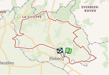
Randonnée Cheval de 22 km à découvrir à Wallonie, Hainaut, Flobecq. Cette randonnée est proposée par Commissariat général au Tourisme.
Description
Randonnée créée par Wallonie Picarde (Antenne Tournai) .
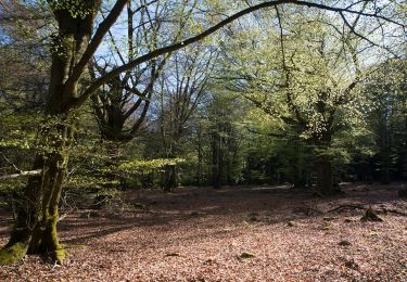
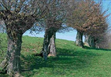
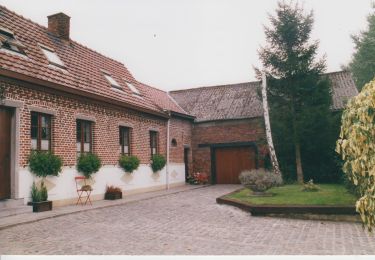
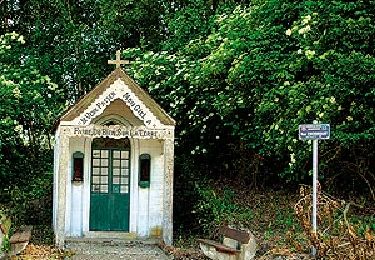
Ces circuits font partie d’un réseau d’itinéraires équestres transfrontaliers. Ce réseau compte plus de 120 km dans la région du Parc naturel du Pays des Collines et est entièrement balisé. N’hésitez pas à passer les frontières vers le Nord, Brakel, vers l’Ouest, Ellezelles (n° 2.04), vers l’Est, Lessines (n° 3.08-3.09-3.10) ou à suivre le Pré RAVeL (ancienne ligne 87) aménagé et inauguré en 2004. Une partie du parcours 2.05 suit le GR 129 et la ligne 87. Quant au circuit "Bois de La Louvière", il est ponctué par de nombreuses "kapellekens", "petites chapelles". Respectez ces lieux, ils sont uniquement entretenus par les villageois. Ecrin de verdure, ce parcours vous offre de nombreuses vues splendides et le calme en toute plénitude.
Site web: https://organismes.tourismewallonie.be/details/ITB-02-0006O3&type=8/
Localisation
Commentaires
Randonnées à proximité
![Randonnée Marche Flobecq - Flobecq, Natura 2000 des sites qui valent le détour. Ht10 - Photo](https://media.geolcdn.com/t/375/260/ext.jpg?maxdim=2&url=https%3A%2F%2Fservices.sitytrail.com%2FGeolivesWS%2FDownloadMedia.ashx%3FTrailID%3D909698%26Media%3D35121b2c-4aba-47c4-9fcc-6708631a1f90.jpg)
![Marche Marche](https://static1.geolcdn.com/sitytour/trail-icons/101.png)
Marche
![](/images/other/stat-length.png)
![](https://static1.geolcdn.com/siteimages/upload/files/16400158638029165_repeat_loop_refresh_sync_direction_icon.png)
![Randonnée Marche Ellezelles - RB-Ha-02 - Ellezelles - 2024-10-29 - Photo](https://media.geolcdn.com/t/375/260/ext.jpg?maxdim=2&url=https%3A%2F%2Fservices.sitytrail.com%2FGeolivesWS%2FDownloadMedia.ashx%3FTrailID%3D217832%26Media%3D2f63cbc9-67e0-4d65-89f9-544523dd5718.jpg)
![Marche Marche](https://static1.geolcdn.com/sitytour/trail-icons/101.png)
Marche
![](/images/other/stat-length.png)
![](https://static1.geolcdn.com/siteimages/upload/files/16400158638029165_repeat_loop_refresh_sync_direction_icon.png)
![Randonnée Marche Ellezelles - Le sentier de l'étrange - Photo](https://media.geolcdn.com/t/375/260/ext.jpg?maxdim=2&url=https%3A%2F%2Fservices.sitytrail.com%2FGeolivesWS%2FDownloadMedia.ashx%3FTrailID%3D202842%26Media%3Dfd094432-4170-43a7-b091-423977983591.jpg)
![Marche Marche](https://static1.geolcdn.com/sitytour/trail-icons/101.png)
Marche
![](/images/other/stat-length.png)
![](https://static1.geolcdn.com/siteimages/upload/files/16400158638029165_repeat_loop_refresh_sync_direction_icon.png)
![Randonnée A pied Bracle - Everbeekpad - Photo](https://media.geolcdn.com/t/375/260/d08ad0f4-de55-4764-95c5-9e3d60aacb5d.jpeg&format=jpg&maxdim=2)
![A pied A pied](https://static1.geolcdn.com/sitytour/trail-icons/100.png)
A pied
![](/images/other/stat-length.png)
![](https://static1.geolcdn.com/siteimages/upload/files/16400158638029165_repeat_loop_refresh_sync_direction_icon.png)
![Randonnée A pied Flobecq - Entre La Houppe et Bos Ter Rijst - Photo](https://media.geolcdn.com/t/375/260/ext.jpg?maxdim=2&url=https%3A%2F%2Fpivotmedia.tourismewallonie.be%2FANX-02-000EUQ%2FANX-02-000EUQ.jpg)
![A pied A pied](https://static1.geolcdn.com/sitytour/trail-icons/100.png)
A pied
![](/images/other/stat-length.png)
![](https://static1.geolcdn.com/siteimages/upload/files/16400158638029165_repeat_loop_refresh_sync_direction_icon.png)
![Randonnée A pied Ellezelles - Promenade Jean Nature - Photo](https://media.geolcdn.com/t/375/260/ext.jpg?maxdim=2&url=https%3A%2F%2Fpivotmedia.tourismewallonie.be%2FANX-02-03ZF-0001%2FANX-02-03ZF-0001.JPG)
![A pied A pied](https://static1.geolcdn.com/sitytour/trail-icons/100.png)
A pied
![](/images/other/stat-length.png)
![](https://static1.geolcdn.com/siteimages/upload/files/16400158638029165_repeat_loop_refresh_sync_direction_icon.png)
![Randonnée A pied Frasnes-lez-Anvaing - La Balade des Hiboux - Photo](https://media.geolcdn.com/t/375/260/ext.jpg?maxdim=2&url=https%3A%2F%2Fpivotmedia.tourismewallonie.be%2FANX-02-000END%2FANX-02-000END.jpg)
![A pied A pied](https://static1.geolcdn.com/sitytour/trail-icons/100.png)
A pied
![](/images/other/stat-length.png)
![](https://static1.geolcdn.com/siteimages/upload/files/16400158638029165_repeat_loop_refresh_sync_direction_icon.png)
![Randonnée A pied Ellezelles - D'Oeudeghien à Buissenal - Photo](https://media.geolcdn.com/t/375/260/ext.jpg?maxdim=2&url=https%3A%2F%2Fpivotmedia.tourismewallonie.be%2FANX-02-000ENJ%2FANX-02-000ENJ.jpg)
![A pied A pied](https://static1.geolcdn.com/sitytour/trail-icons/100.png)
A pied
![](/images/other/stat-length.png)
![](https://static1.geolcdn.com/siteimages/upload/files/16400158638029165_repeat_loop_refresh_sync_direction_icon.png)
![Randonnée A pied Ellezelles - Balade au pays de Petite Elle - Photo](https://media.geolcdn.com/t/375/260/ext.jpg?maxdim=2&url=https%3A%2F%2Fpivotmedia.tourismewallonie.be%2FANX-02-000EMF%2FANX-02-000EMF.jpg)
![A pied A pied](https://static1.geolcdn.com/sitytour/trail-icons/100.png)
A pied
![](/images/other/stat-length.png)
![](https://static1.geolcdn.com/siteimages/upload/files/16400158638029165_repeat_loop_refresh_sync_direction_icon.png)