![](/images/other/stat-length.png)
Circuit de la coupure de Bléharies - 1km
Commissariat général au Tourisme
Randonnées du CGT GUIDE+
![Longueur](/images/other/stat-length.png)
![Altitude max](https://static1.geolcdn.com/siteimages/upload/files/1508320355ic_sort_altitude_max_24dp.png)
![Dénivelé positif](https://static1.geolcdn.com/siteimages/upload/files/1508320355ic_sort_den_pos_24dp.png)
![Km-Effort](/images/other/stat-length.png)
![Altitude min](https://static1.geolcdn.com/siteimages/upload/files/1508320355ic_sort_altitude_min_24dp.png)
![Dénivelé négatif](https://static1.geolcdn.com/siteimages/upload/files/1508320355ic_sort_den_neg_24dp.png)
![Boucle](https://static1.geolcdn.com/siteimages/upload/files/16400158638029165_repeat_loop_refresh_sync_direction_icon.png)
![A pied](https://static1.geolcdn.com/sitytour/trail-icons/100.png)
16m
Difficulté : Facile
![Scannez ce code QR pour ouvrir la randonnée dans l'application SityTrail](https://capi.geolives.com/qq0zvz2zws4bq2lad0pu/sitytour/trails/3081422/qr.png?size=200)
Application GPS de randonnée GRATUITE
À propos
Randonnée A pied de 1,2 km à découvrir à Wallonie, Hainaut, Brunehaut. Cette randonnée est proposée par Commissariat général au Tourisme.
Description
Randonnée créée par Wallonie Picarde (Antenne Tournai) .
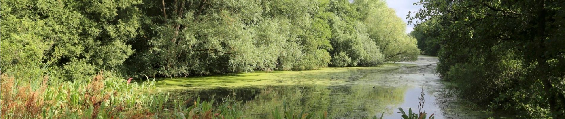
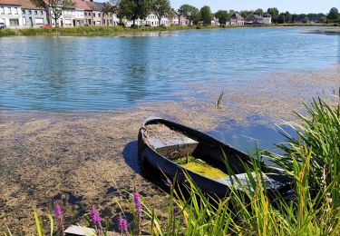
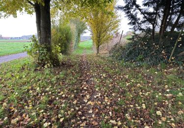
Située sur la rive droite de l’Escaut, à l’est du petit village de Bléharies, la coupure (ou noue) de Bléharies serpente entre prairies pâturées et bandes boisées qui lui confèrent, par endroits, une ambiance forestière. Ces anciens méandres sont des endroits propices pour le développement d’une faune et d’une flore caractéristiques des milieux humides.
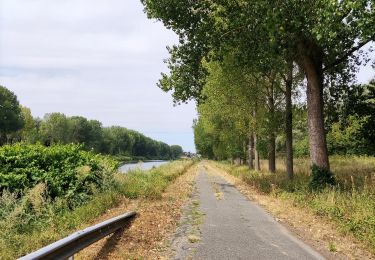
Les circuits de 1, 2 ou 3,5 kilomètres, parfaitement adaptés aux enfants, vous emmènent sur des petits sentiers et sur le RAVeL (voie verte) de l’Escaut canalisé. Arrêtez-vous dans un des deux observatoires pour admirer les espèces animales et végétales en toute tranquillité. Peut-être aurez-vous la chance de voir un Martin-pêcheur passer à côté des batraciens ou des libellules...…
Site web: https://organismes.tourismewallonie.be/details/ITB-02-000A5P&type=8/
Localisation
Commentaires
Randonnées à proximité
![Randonnée Marche Antoing - grand large- penonnes lez antoing - Photo](https://media.geolcdn.com/t/375/260/ext.jpg?maxdim=2&url=https%3A%2F%2Fservices.sitytrail.com%2FGeolivesWS%2FDownloadMedia.ashx%3FTrailID%3D653025%26Media%3Dfix__20161029165326.jpg)
![Marche Marche](https://static1.geolcdn.com/sitytour/trail-icons/101.png)
Marche
![](/images/other/stat-length.png)
![](https://static1.geolcdn.com/siteimages/upload/files/16400158638029165_repeat_loop_refresh_sync_direction_icon.png)
![Randonnée Marche Brunehaut - Circuit de la coupure de Bléharies - Photo](https://media.geolcdn.com/t/375/260/c388fd6c-a6df-4e66-add0-50e55c75a52e.jpg&format=jpg&maxdim=2)
![Marche Marche](https://static1.geolcdn.com/sitytour/trail-icons/101.png)
Marche
![](/images/other/stat-length.png)
![](https://static1.geolcdn.com/siteimages/upload/files/16400158638029165_repeat_loop_refresh_sync_direction_icon.png)
![Randonnée Marche Antoing - Balade au coeur de Péronnes - Photo](https://media.geolcdn.com/t/375/260/d7561409-c7bf-436c-aa67-e1ca13223359.jpg&format=jpg&maxdim=2)
![Marche Marche](https://static1.geolcdn.com/sitytour/trail-icons/101.png)
Marche
![](/images/other/stat-length.png)
![](https://static1.geolcdn.com/siteimages/upload/files/16400158638029165_repeat_loop_refresh_sync_direction_icon.png)
![Randonnée Cheval Brunehaut - Boucle de Brunehaut - Photo](https://media.geolcdn.com/t/375/260/ext.jpg?maxdim=2&url=https%3A%2F%2Fpivotmedia.tourismewallonie.be%2FANX-02-000EI9%2FANX-02-000EI9.jpg)
![Cheval Cheval](https://static1.geolcdn.com/sitytour/trail-icons/300.png)
Cheval
![](/images/other/stat-length.png)
![](https://static1.geolcdn.com/siteimages/upload/files/16400158638029165_repeat_loop_refresh_sync_direction_icon.png)
![Randonnée A pied Brunehaut - Circuit des pépinières de Lesdain - Photo](https://media.geolcdn.com/t/375/260/ext.jpg?maxdim=2&url=https%3A%2F%2Fpivotmedia.tourismewallonie.be%2FANX-02-04JM-0024%2FANX-02-04JM-0024.jpg)
![A pied A pied](https://static1.geolcdn.com/sitytour/trail-icons/100.png)
A pied
![](/images/other/stat-length.png)
![](https://static1.geolcdn.com/siteimages/upload/files/16400158638029165_repeat_loop_refresh_sync_direction_icon.png)
![Randonnée A pied Brunehaut - Circuit de la coupure de Bléharies - 3,5km - Photo](https://media.geolcdn.com/t/375/260/ext.jpg?maxdim=2&url=https%3A%2F%2Fpivotmedia.tourismewallonie.be%2FANX-02-04JP-002T%2FANX-02-04JP-002T.jpg)
![A pied A pied](https://static1.geolcdn.com/sitytour/trail-icons/100.png)
A pied
![](/images/other/stat-length.png)
![](https://static1.geolcdn.com/siteimages/upload/files/16400158638029165_repeat_loop_refresh_sync_direction_icon.png)
![Randonnée Marche Mortagne-du-Nord - Mortagne-du-Nord 18,6 km - Photo](https://media.geolcdn.com/t/375/260/fd97f041-03e8-458c-b32d-9e5c0c535a41.jpg&format=jpg&maxdim=2)
![Marche Marche](https://static1.geolcdn.com/sitytour/trail-icons/101.png)
Marche
![](/images/other/stat-length.png)
![](https://static1.geolcdn.com/siteimages/upload/files/16400158638029165_repeat_loop_refresh_sync_direction_icon.png)
![Randonnée Marche Brunehaut - RB - H - 15 Lesdain - Photo](https://media.geolcdn.com/t/375/260/ext.jpg?maxdim=2&url=https%3A%2F%2Fservices.sitytrail.com%2FGeolivesWS%2FDownloadMedia.ashx%3FTrailID%3D617918%26Media%3Dfix__20160820190940.jpg)
![Marche Marche](https://static1.geolcdn.com/sitytour/trail-icons/101.png)
Marche
![](/images/other/stat-length.png)
![](https://static1.geolcdn.com/siteimages/upload/files/16400158638029165_repeat_loop_refresh_sync_direction_icon.png)
![Randonnée Marche Brunehaut - Hollain 16,2 km - Photo](https://media.geolcdn.com/t/375/260/d4f347cb-4477-4f70-b6a4-646a3766b293.jpg&format=jpg&maxdim=2)
![Marche Marche](https://static1.geolcdn.com/sitytour/trail-icons/101.png)
Marche
![](/images/other/stat-length.png)
![](https://static1.geolcdn.com/siteimages/upload/files/16400158638029165_repeat_loop_refresh_sync_direction_icon.png)