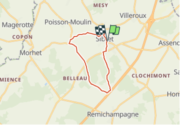
![](/images/other/stat-length.png)
![Randonnée A pied Vaux-sur-Sûre - Promenade du Renard - Photo](https://media.geolcdn.com/t/1900/400/ext.pjpeg?maxdim=2&url=https%3A%2F%2Fstatic1.geolcdn.com%2Fsiteimages%2Fupload%2Ffiles%2F1545311037marcheuse_200dpi.jpg)
Promenade du Renard
Commissariat général au Tourisme
Randonnées du CGT GUIDE+
![Longueur](/images/other/stat-length.png)
![Altitude max](https://static1.geolcdn.com/siteimages/upload/files/1508320355ic_sort_altitude_max_24dp.png)
![Dénivelé positif](https://static1.geolcdn.com/siteimages/upload/files/1508320355ic_sort_den_pos_24dp.png)
![Km-Effort](/images/other/stat-length.png)
![Altitude min](https://static1.geolcdn.com/siteimages/upload/files/1508320355ic_sort_altitude_min_24dp.png)
![Dénivelé négatif](https://static1.geolcdn.com/siteimages/upload/files/1508320355ic_sort_den_neg_24dp.png)
![Boucle](https://static1.geolcdn.com/siteimages/upload/files/16400158638029165_repeat_loop_refresh_sync_direction_icon.png)
![A pied](https://static1.geolcdn.com/sitytour/trail-icons/100.png)
2h29
Difficulté : Facile
![Scannez ce code QR pour ouvrir la randonnée dans l'application SityTrail](https://capi.geolives.com/qq0zvz2zws4bq2lad0pu/sitytour/trails/3081156/qr.png?size=200)
Application GPS de randonnée GRATUITE
À propos
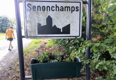
Randonnée A pied de 9 km à découvrir à Wallonie, Luxembourg, Vaux-sur-Sûre. Cette randonnée est proposée par Commissariat général au Tourisme.
Description
Randonnée créée par Haute-Süre Forêt d'Anlier en Ardenne.
Après quelques kilomètres, vous tombez en admiration devant un chêne multi-centenaire, prénommé l’arbre à café par les bambins du coin car on trouve dans ses anfractuosités comme du café. Aux alentours s’étendent des forêts caractéristiques du plateau ardennais avec une prédominance d’épicéas. En poursuivant votre balade, vous traversez le Ravel (ancienne voie de chemin de fer Libramont-Bastogne-Gouvy) et vous rencontrez sur la fin une grotte construite après l’offensive des Ardennes de décembre 1944.
Site web: https://organismes.tourismewallonie.be/details/ITB-01-000B03&type=8/
Localisation
Commentaires
Randonnées à proximité
![Randonnée Marche Vaux-sur-Sûre - Hompré. Natura 2000, des sites qui valent le détour. Lx8 - Photo](https://media.geolcdn.com/t/375/260/ext.jpg?maxdim=2&url=https%3A%2F%2Fservices.sitytrail.com%2FGeolivesWS%2FDownloadMedia.ashx%3FTrailID%3D163750%26Media%3D9b92826d-7fd7-4872-9569-36ed8015d89e.jpg)
![Marche Marche](https://static1.geolcdn.com/sitytour/trail-icons/101.png)
Marche
![](/images/other/stat-length.png)
![](https://static1.geolcdn.com/siteimages/upload/files/16400158638029165_repeat_loop_refresh_sync_direction_icon.png)
![Randonnée Marche Sainte-Ode - Magerotte - Promenade des Haies de Magery (T4) - Photo](https://media.geolcdn.com/t/375/260/ext.jpg?maxdim=2&url=https%3A%2F%2Fstatic1.geolcdn.com%2Fsiteimages%2Fupload%2Ffiles%2F1553511878bg_sport_marche.png)
![Marche Marche](https://static1.geolcdn.com/sitytour/trail-icons/101.png)
Marche
![](/images/other/stat-length.png)
![](https://static1.geolcdn.com/siteimages/upload/files/16400158638029165_repeat_loop_refresh_sync_direction_icon.png)
![Randonnée Marche Sainte-Ode - Rechrival - Promenade des Haies des Valets (T3) - Photo](https://media.geolcdn.com/t/375/260/ext.jpg?maxdim=2&url=https%3A%2F%2Fstatic1.geolcdn.com%2Fsiteimages%2Fupload%2Ffiles%2F1553511878bg_sport_marche.png)
![Marche Marche](https://static1.geolcdn.com/sitytour/trail-icons/101.png)
Marche
![](/images/other/stat-length.png)
![](https://static1.geolcdn.com/siteimages/upload/files/16400158638029165_repeat_loop_refresh_sync_direction_icon.png)
![Randonnée A pied Vaux-sur-Sûre - Promenade des Vanneaux - Photo](https://media.geolcdn.com/t/375/260/f25bda7f-df07-4cae-a9a3-cfe0c9000b2b.jpeg&format=jpg&maxdim=2)
![A pied A pied](https://static1.geolcdn.com/sitytour/trail-icons/100.png)
A pied
![](/images/other/stat-length.png)
![](https://static1.geolcdn.com/siteimages/upload/files/16400158638029165_repeat_loop_refresh_sync_direction_icon.png)
![Randonnée Marche Bastogne - Bastogne - Photo](https://media.geolcdn.com/t/375/260/c8ea2498-5648-4f6f-9372-83bfe35ec759.jpg&format=jpg&maxdim=2)
![Marche Marche](https://static1.geolcdn.com/sitytour/trail-icons/101.png)
Marche
![](/images/other/stat-length.png)
![](https://static1.geolcdn.com/siteimages/upload/files/16400158638029165_repeat_loop_refresh_sync_direction_icon.png)
![Randonnée Marche Bastogne - Marche 10 km 500 à Senonchamps. - Photo](https://media.geolcdn.com/t/375/260/5a88fca4-6ef8-4891-b167-25135544c6f2.jpg&format=jpg&maxdim=2)
![Marche Marche](https://static1.geolcdn.com/sitytour/trail-icons/101.png)
Marche
![](/images/other/stat-length.png)
![](https://static1.geolcdn.com/siteimages/upload/files/16400158638029165_repeat_loop_refresh_sync_direction_icon.png)
![Randonnée A pied Vaux-sur-Sûre - Promenade de la Truite - Photo](https://media.geolcdn.com/t/375/260/dc8e6a7d-10c2-483c-849c-2c2e40a6aa00.jpeg&format=jpg&maxdim=2)
![A pied A pied](https://static1.geolcdn.com/sitytour/trail-icons/100.png)
A pied
![](/images/other/stat-length.png)
![](https://static1.geolcdn.com/siteimages/upload/files/16400158638029165_repeat_loop_refresh_sync_direction_icon.png)
![Randonnée A pied Vaux-sur-Sûre - Promenade du Loup - Photo](https://media.geolcdn.com/t/375/260/a4b7c189-2aa3-4341-b070-c509f488a2a0.jpeg&format=jpg&maxdim=2)
![A pied A pied](https://static1.geolcdn.com/sitytour/trail-icons/100.png)
A pied
![](/images/other/stat-length.png)
![](https://static1.geolcdn.com/siteimages/upload/files/16400158638029165_repeat_loop_refresh_sync_direction_icon.png)
![Randonnée A pied Vaux-sur-Sûre - Promenade du Renardeau - Photo](https://media.geolcdn.com/t/375/260/a4b7c189-2aa3-4341-b070-c509f488a2a0.jpeg&format=jpg&maxdim=2)
![A pied A pied](https://static1.geolcdn.com/sitytour/trail-icons/100.png)
A pied
![](/images/other/stat-length.png)
![](https://static1.geolcdn.com/siteimages/upload/files/16400158638029165_repeat_loop_refresh_sync_direction_icon.png)