![](/images/other/stat-length.png)
![Randonnée A pied Visé - Lanaye (I2-4 Vert) : Par delà les rives - Montagne Saint-Pierre - Photo](https://media.geolcdn.com/t/1900/400/ext.pjpeg?maxdim=2&url=https%3A%2F%2Fpivotmedia.tourismewallonie.be%2FOTH-A0-005L-1KHQ%2FOTH-A0-005L-1KHQ.jpg)
Lanaye (I2-4 Vert) : Par delà les rives - Montagne Saint-Pierre
Commissariat général au Tourisme
Randonnées du CGT GUIDE+
![Longueur](/images/other/stat-length.png)
![Altitude max](https://static1.geolcdn.com/siteimages/upload/files/1508320355ic_sort_altitude_max_24dp.png)
![Dénivelé positif](https://static1.geolcdn.com/siteimages/upload/files/1508320355ic_sort_den_pos_24dp.png)
![Km-Effort](/images/other/stat-length.png)
![Altitude min](https://static1.geolcdn.com/siteimages/upload/files/1508320355ic_sort_altitude_min_24dp.png)
![Dénivelé négatif](https://static1.geolcdn.com/siteimages/upload/files/1508320355ic_sort_den_neg_24dp.png)
![Boucle](https://static1.geolcdn.com/siteimages/upload/files/16400158638029165_repeat_loop_refresh_sync_direction_icon.png)
![A pied](https://static1.geolcdn.com/sitytour/trail-icons/100.png)
43m
Difficulté : Facile
![Scannez ce code QR pour ouvrir la randonnée dans l'application SityTrail](https://capi.geolives.com/qq0zvz2zws4bq2lad0pu/sitytour/trails/3081117/qr.png?size=200)
Application GPS de randonnée GRATUITE
À propos
Randonnée A pied de 2,9 km à découvrir à Wallonie, Liège, Visé. Cette randonnée est proposée par Commissariat général au Tourisme.
Description
Randonnée créée par Pays de Herve.
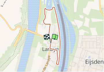
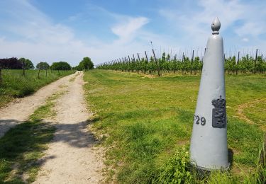
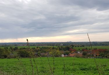
Par delà les rives de la Meuse et du Canal Albert, aux portes de la Montagne Saint-Pierre, cette petite balade facile de 3 km vous emmène à la découverte du village de Lanaye, le long de la Meuse.
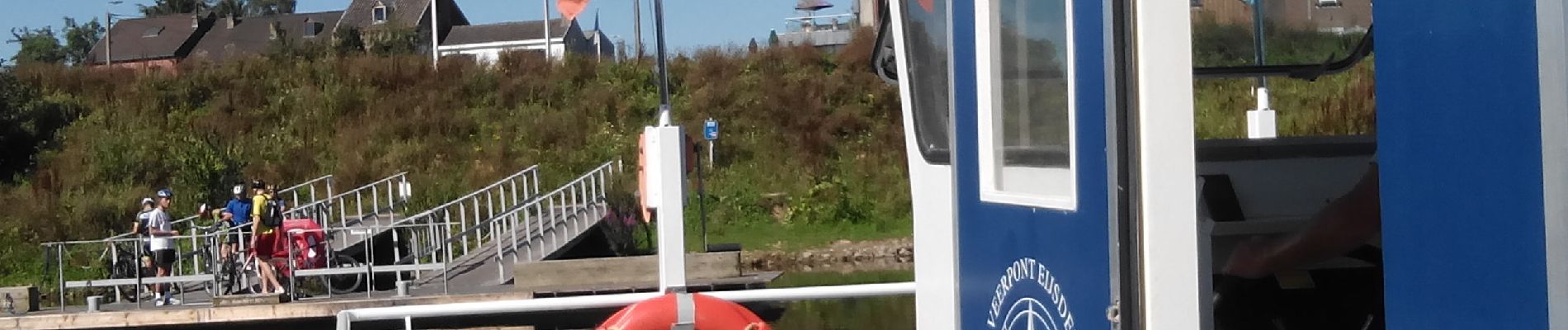
Profitez de votre passage le week-end pour une visite de la Maison de la Montagne Saint-Pierre, et en saison (de mai à septembre et en fonction des conditions météorologiques), prenez le Bac Cramignon pour traverser la frontière nationale et visiter le village de Eijsden aux Pays-Bas !
Non accessible aux personnes à mobilité réduite. En période sèche accessible avec poussette bébé.
Plus d'infos sur les balades transfrontalières de la Montagne Saint-Pierre sur www.montagnesaintpierre.org
Site web: https://organismes.tourismewallonie.be/details/LOD-A0-0030-28V0&type=8/
Localisation
Commentaires
Randonnées à proximité
![Randonnée Marche Visé - montagne saint pierre - Photo](https://media.geolcdn.com/t/375/260/ext.jpg?maxdim=2&url=https%3A%2F%2Fservices.sitytrail.com%2FGeolivesWS%2FDownloadMedia.ashx%3FTrailID%3D308205%26Media%3D20140601165318.jpg)
![Marche Marche](https://static1.geolcdn.com/sitytour/trail-icons/101.png)
Marche
![](/images/other/stat-length.png)
![](https://static1.geolcdn.com/siteimages/upload/files/16400158638029165_repeat_loop_refresh_sync_direction_icon.png)
![Randonnée Marche Eijsden-Margraten - Eijsden - E8 - Bloesemroute-3 - Photo](https://media.geolcdn.com/t/375/260/7792b7db-95a9-4b53-8cd5-7eae3fedc6a4.jpg&format=jpg&maxdim=2)
![Marche Marche](https://static1.geolcdn.com/sitytour/trail-icons/101.png)
Marche
![](/images/other/stat-length.png)
![](https://static1.geolcdn.com/siteimages/upload/files/16400158638029165_repeat_loop_refresh_sync_direction_icon.png)
![Randonnée Marche Eijsden-Margraten - Mesch [Eijsden - E5] - Photo](https://media.geolcdn.com/t/375/260/cb3c0103-7b73-4049-ab47-8594df511d3c.jpg&format=jpg&maxdim=2)
![Marche Marche](https://static1.geolcdn.com/sitytour/trail-icons/101.png)
Marche
![](/images/other/stat-length.png)
![](https://static1.geolcdn.com/siteimages/upload/files/16400158638029165_repeat_loop_refresh_sync_direction_icon.png)
![Randonnée Marche Riemst - Kanne_1192 - Photo](https://media.geolcdn.com/t/375/260/63b86f10-f314-488d-80d4-00787e3a9126.jpg&format=jpg&maxdim=2)
![Marche Marche](https://static1.geolcdn.com/sitytour/trail-icons/101.png)
![Randonnée Marche Eijsden-Margraten - Eijsden - Savelbos - Photo](https://media.geolcdn.com/t/375/260/1a835e4b-4203-472e-b4f4-bdf046d29220.jpg&format=jpg&maxdim=2)
![Marche Marche](https://static1.geolcdn.com/sitytour/trail-icons/101.png)
Marche
![](/images/other/stat-length.png)
![](https://static1.geolcdn.com/siteimages/upload/files/16400158638029165_repeat_loop_refresh_sync_direction_icon.png)
![Randonnée Marche Eijsden-Margraten - Gronsveld_1327 - Photo](https://media.geolcdn.com/t/375/260/877eed2d-204c-4212-a49e-caf4fc574b56.jpg&format=jpg&maxdim=2)
![Marche Marche](https://static1.geolcdn.com/sitytour/trail-icons/101.png)
Marche
![](/images/other/stat-length.png)
![](https://static1.geolcdn.com/siteimages/upload/files/16400158638029165_repeat_loop_refresh_sync_direction_icon.png)
![Randonnée Marche Eijsden-Margraten - E9 - Mesch - Mouland - Photo](https://media.geolcdn.com/t/375/260/44ba086f-f486-4631-8c1f-b562699d8ecb.jpg&format=jpg&maxdim=2)
![Marche Marche](https://static1.geolcdn.com/sitytour/trail-icons/101.png)
Marche
![](/images/other/stat-length.png)
![](https://static1.geolcdn.com/siteimages/upload/files/16400158638029165_repeat_loop_refresh_sync_direction_icon.png)
![Randonnée Marche Eijsden-Margraten - Mesch - Photo](https://media.geolcdn.com/t/375/260/877552c4-bc60-4040-89d8-1feef8999df8.jpg&format=jpg&maxdim=2)
![Marche Marche](https://static1.geolcdn.com/sitytour/trail-icons/101.png)
Marche
![](/images/other/stat-length.png)
![](https://static1.geolcdn.com/siteimages/upload/files/16400158638029165_repeat_loop_refresh_sync_direction_icon.png)
![Randonnée Marche Eijsden-Margraten - Withuis - Mesch _1423 - Photo](https://media.geolcdn.com/t/375/260/2350ca5b-021f-42ad-8440-981e9d82c1d0.jpg&format=jpg&maxdim=2)
![Marche Marche](https://static1.geolcdn.com/sitytour/trail-icons/101.png)
Marche
![](/images/other/stat-length.png)
![](https://static1.geolcdn.com/siteimages/upload/files/16400158638029165_repeat_loop_refresh_sync_direction_icon.png)