![](/images/other/stat-length.png)
![Randonnée Marche Marval - milhaguet les hautes forets - Photo](https://media.geolcdn.com/t/1900/400/ext.pjpeg?maxdim=2&url=https%3A%2F%2Fservices.sitytrail.com%2FGeolivesWS%2FDownloadMedia.ashx%3FTrailID%3D308097%26Media%3D2ca97c03-e495-49f8-b72e-b467ed5ba444.jpg)
milhaguet les hautes forets
rougilabuse
Utilisateur
![Longueur](/images/other/stat-length.png)
Longueur
13,5 km
![Altitude max](https://static1.geolcdn.com/siteimages/upload/files/1508320355ic_sort_altitude_max_24dp.png)
Altitude max
479 m
![Dénivelé positif](https://static1.geolcdn.com/siteimages/upload/files/1508320355ic_sort_den_pos_24dp.png)
Dénivelé positif
230 m
![Km-Effort](/images/other/stat-length.png)
Km-Effort
16,6 km
![Altitude min](https://static1.geolcdn.com/siteimages/upload/files/1508320355ic_sort_altitude_min_24dp.png)
Altitude min
341 m
![Dénivelé négatif](https://static1.geolcdn.com/siteimages/upload/files/1508320355ic_sort_den_neg_24dp.png)
Dénivelé négatif
227 m
![Boucle](https://static1.geolcdn.com/siteimages/upload/files/16400158638029165_repeat_loop_refresh_sync_direction_icon.png)
Boucle
Oui
Date de création :
2014-12-10 00:00:00.0
Dernière modification :
2014-12-10 00:00:00.0
![Marche](https://static1.geolcdn.com/sitytour/trail-icons/101.png)
3h38
Difficulté : Facile
![Scannez ce code QR pour ouvrir la randonnée dans l'application SityTrail](https://capi.geolives.com/qq0zvz2zws4bq2lad0pu/sitytour/trails/308097/qr.png?size=200)
Application GPS de randonnée GRATUITE
À propos
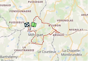
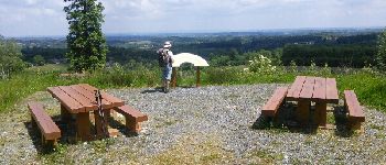
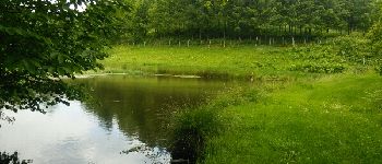
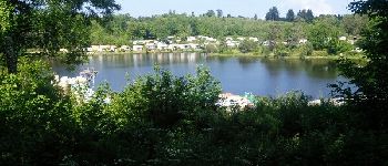
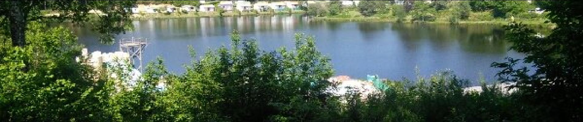
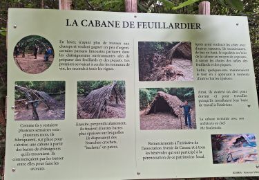
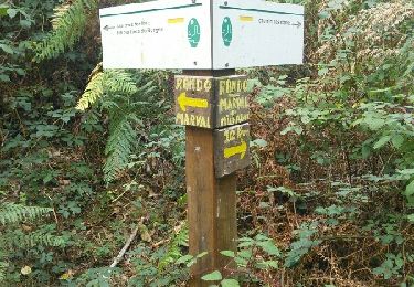
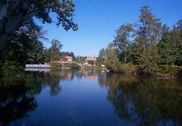
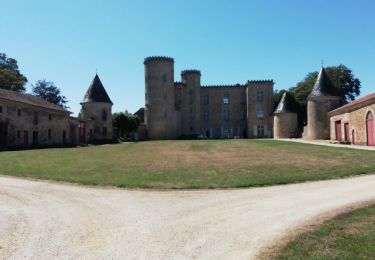
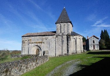
Randonnée Marche de 13,5 km à découvrir à Nouvelle-Aquitaine, Haute-Vienne, Marval. Cette randonnée est proposée par rougilabuse.
Description
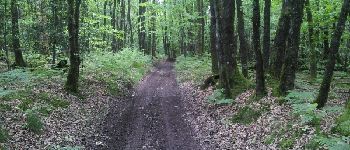
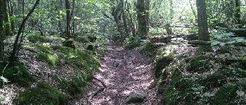
Circuit proposé par le Comité Départemental du Tourisme de la Haute-Vienne sur le site www.randonnee-hautevienne.com Trés belle rando, beaucoup de forets à faire quand il fait chaud ou en automne.
Localisation
Pays :
France
Région :
Nouvelle-Aquitaine
Département/Province :
Haute-Vienne
Commune :
Marval
Localité :
Unknown
Départ:(Dec)
Départ:(UTM)
327911 ; 5059574 (31T) N.
Commentaires
Randonnées à proximité
![Randonnée Marche Cussac - boubon - Photo](https://media.geolcdn.com/t/375/260/19e2e557-c72c-4e8e-b512-f1d419509aac.jpg&format=jpg&maxdim=2)
![Marche Marche](https://static1.geolcdn.com/sitytour/trail-icons/101.png)
boubon
Marche
Facile
Cussac,
Nouvelle-Aquitaine,
Haute-Vienne,
France
![](/images/other/stat-length.png)
3,5 km | 4,6 km-effort
1h 0min
![](https://static1.geolcdn.com/siteimages/upload/files/16400158638029165_repeat_loop_refresh_sync_direction_icon.png)
Oui
![Randonnée Trail Cussac - tour des fontaines cussac - Photo](https://media.geolcdn.com/t/375/260/4221c026-cd62-4d82-ac22-7e4ba88e7b56.jpg&format=jpg&maxdim=2)
![Trail Trail](https://static1.geolcdn.com/sitytour/trail-icons/104.png)
tour des fontaines cussac
Trail
Très facile
Cussac,
Nouvelle-Aquitaine,
Haute-Vienne,
France
![](/images/other/stat-length.png)
11,9 km | 14,5 km-effort
1h 24min
![](https://static1.geolcdn.com/siteimages/upload/files/16400158638029165_repeat_loop_refresh_sync_direction_icon.png)
Oui
![Randonnée Marche Marval - puy chevalier - Photo](https://media.geolcdn.com/t/375/260/ext.jpg?maxdim=2&url=https%3A%2F%2Fservices.sitytrail.com%2FGeolivesWS%2FDownloadMedia.ashx%3FTrailID%3D644486%26Media%3Dfix__20161011111424.jpg)
![Marche Marche](https://static1.geolcdn.com/sitytour/trail-icons/101.png)
puy chevalier
Marche
Facile
(1)
Marval,
Nouvelle-Aquitaine,
Haute-Vienne,
France
![](/images/other/stat-length.png)
12,2 km | 14,4 km-effort
3h 35min
![](https://static1.geolcdn.com/siteimages/upload/files/16400158638029165_repeat_loop_refresh_sync_direction_icon.png)
Oui
![Randonnée Marche Saint-Mathieu - Château Rocher - Photo](https://media.geolcdn.com/t/375/260/ext.jpg?maxdim=2&url=https%3A%2F%2Fservices.sitytrail.com%2FGeolivesWS%2FDownloadMedia.ashx%3FTrailID%3D266615%26Media%3Dc8c4107a-d1f3-4f05-bb14-ddbfef1dfc3a.jpg)
![Marche Marche](https://static1.geolcdn.com/sitytour/trail-icons/101.png)
Château Rocher
Marche
Moyen
Saint-Mathieu,
Nouvelle-Aquitaine,
Haute-Vienne,
France
![](/images/other/stat-length.png)
21 km | 25 km-effort
5h 29min
![](https://static1.geolcdn.com/siteimages/upload/files/16400158638029165_repeat_loop_refresh_sync_direction_icon.png)
Oui
![Randonnée Marche Cussac - Cussac forêt de cromieres - Photo](https://media.geolcdn.com/t/375/260/33da363c-183a-4a1d-b910-be7fa6f268a7.jpg&format=jpg&maxdim=2)
![Marche Marche](https://static1.geolcdn.com/sitytour/trail-icons/101.png)
Cussac forêt de cromieres
Marche
Très facile
(1)
Cussac,
Nouvelle-Aquitaine,
Haute-Vienne,
France
![](/images/other/stat-length.png)
8 km | 9,9 km-effort
2h 28min
![](https://static1.geolcdn.com/siteimages/upload/files/16400158638029165_repeat_loop_refresh_sync_direction_icon.png)
Non
![Randonnée Marche Saint-Barthélemy-de-Bussière - Saint Barthelemy de Bussière boucle1 - Photo](https://media.geolcdn.com/t/375/260/ext.jpg?maxdim=2&url=https%3A%2F%2Fstatic1.geolcdn.com%2Fsiteimages%2Fupload%2Ffiles%2F1553511878bg_sport_marche.png)
![Marche Marche](https://static1.geolcdn.com/sitytour/trail-icons/101.png)
Saint Barthelemy de Bussière boucle1
Marche
Moyen
Saint-Barthélemy-de-Bussière,
Nouvelle-Aquitaine,
Dordogne,
France
![](/images/other/stat-length.png)
14,5 km | 18,7 km-effort
4h 3min
![](https://static1.geolcdn.com/siteimages/upload/files/16400158638029165_repeat_loop_refresh_sync_direction_icon.png)
Oui
![Randonnée Marche Champniers-et-Reilhac - champniers - Photo](https://media.geolcdn.com/t/375/260/ext.jpg?maxdim=2&url=https%3A%2F%2Fservices.sitytrail.com%2FGeolivesWS%2FDownloadMedia.ashx%3FTrailID%3D487445%26Media%3Dfix__20151030111843.jpg)
![Marche Marche](https://static1.geolcdn.com/sitytour/trail-icons/101.png)
champniers
Marche
Moyen
Champniers-et-Reilhac,
Nouvelle-Aquitaine,
Dordogne,
France
![](/images/other/stat-length.png)
14,8 km | 18,5 km-effort
4h 50min
![](https://static1.geolcdn.com/siteimages/upload/files/16400158638029165_repeat_loop_refresh_sync_direction_icon.png)
Oui
![Randonnée Marche Saint-Mathieu - St Mathieu - Photo](https://media.geolcdn.com/t/375/260/ext.jpg?maxdim=2&url=https%3A%2F%2Fstatic1.geolcdn.com%2Fsiteimages%2Fupload%2Ffiles%2F1553511878bg_sport_marche.png)
![Marche Marche](https://static1.geolcdn.com/sitytour/trail-icons/101.png)
St Mathieu
Marche
Saint-Mathieu,
Nouvelle-Aquitaine,
Haute-Vienne,
France
![](/images/other/stat-length.png)
7,5 km | 9,4 km-effort
2h 26min
![](https://static1.geolcdn.com/siteimages/upload/files/16400158638029165_repeat_loop_refresh_sync_direction_icon.png)
Non
![Randonnée sport Cussac - 2023-09-27_17h57m23_cussac_voie_romaine_cromiere-14583817-1673715285-378 - Photo](https://media.geolcdn.com/t/375/260/ext.jpg?maxdim=2&url=https%3A%2F%2Fsecurestorage.geolives.com%2Fsitytour%2Ftrail-bg%2Fdefault.jpg)
2023-09-27_17h57m23_cussac_voie_romaine_cromiere-14583817-1673715285-378
sport
Très facile
Cussac,
Nouvelle-Aquitaine,
Haute-Vienne,
France
![](/images/other/stat-length.png)
16,6 km | 20 km-effort
Inconnu
![](https://static1.geolcdn.com/siteimages/upload/files/16400158638029165_repeat_loop_refresh_sync_direction_icon.png)
Oui