![](/images/other/stat-length.png)
![Randonnée V.T.T. Esneux - Esneux - Circuit N° 4 - Photo](https://media.geolcdn.com/t/1900/400/ext.pjpeg?maxdim=2&url=https%3A%2F%2Fpivotmedia.tourismewallonie.be%2FOTH-A0-004Y-054F%2FOTH-A0-004Y-054F.jpg)
Esneux - Circuit N° 4
Commissariat général au Tourisme
Randonnées du CGT GUIDE+
![Longueur](/images/other/stat-length.png)
![Altitude max](https://static1.geolcdn.com/siteimages/upload/files/1508320355ic_sort_altitude_max_24dp.png)
![Dénivelé positif](https://static1.geolcdn.com/siteimages/upload/files/1508320355ic_sort_den_pos_24dp.png)
![Km-Effort](/images/other/stat-length.png)
![Altitude min](https://static1.geolcdn.com/siteimages/upload/files/1508320355ic_sort_altitude_min_24dp.png)
![Dénivelé négatif](https://static1.geolcdn.com/siteimages/upload/files/1508320355ic_sort_den_neg_24dp.png)
![Boucle](https://static1.geolcdn.com/siteimages/upload/files/16400158638029165_repeat_loop_refresh_sync_direction_icon.png)
![V.T.T.](https://static1.geolcdn.com/sitytour/trail-icons/202.png)
1h50
Difficulté : Moyen
![V.T.C.](https://static1.geolcdn.com/sitytour/trail-icons/203.png)
--
Difficulté : Moyen
![Scannez ce code QR pour ouvrir la randonnée dans l'application SityTrail](https://capi.geolives.com/qq0zvz2zws4bq2lad0pu/sitytour/trails/3080797/qr.png?size=200)
Application GPS de randonnée GRATUITE
À propos
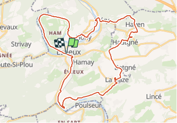
Randonnée V.T.T. de 22 km à découvrir à Wallonie, Liège, Esneux. Cette randonnée est proposée par Commissariat général au Tourisme.
Description
Randonnée créée par Ourthe Vesdre Amblève.
Circuit partant de Esneux. Passages à Souverain-Pré, La Gombe (centre de plongée), Montfort (belle montée), Chaply, Flagothier, le plateau de Fontin, Hautgné, le vallon du ruisseau du Gobry, retour via Méry, le village de Hony et l'intérieur de la Boucle de l'Ourthe.
Site web: https://ovatourisme.be/details/ITB-01-000AAK&type=8/
Localisation
Commentaires
Randonnées à proximité
![Randonnée Marche Esneux - Esneux bois du mary - Photo](https://media.geolcdn.com/t/375/260/71c77441-f9b7-4220-bb0a-fbf9c3317653.jpg&format=jpg&maxdim=2)
![Marche Marche](https://static1.geolcdn.com/sitytour/trail-icons/101.png)
Marche
![](/images/other/stat-length.png)
![](https://static1.geolcdn.com/siteimages/upload/files/16400158638029165_repeat_loop_refresh_sync_direction_icon.png)
![Randonnée Marche Esneux - RB-Lg-20_Tilff - Photo](https://media.geolcdn.com/t/375/260/ext.jpg?maxdim=2&url=https%3A%2F%2Fservices.sitytrail.com%2FGeolivesWS%2FDownloadMedia.ashx%3FTrailID%3D400739%26Media%3D2cb4df8e-af53-4650-9797-54389fe3086f.jpg)
![Marche Marche](https://static1.geolcdn.com/sitytour/trail-icons/101.png)
Marche
![](/images/other/stat-length.png)
![](https://static1.geolcdn.com/siteimages/upload/files/16400158638029165_repeat_loop_refresh_sync_direction_icon.png)
![Randonnée Marche Neupré - Neupré - les contreforts de la Boucle de l'Ourthe - Photo](https://media.geolcdn.com/t/375/260/ext.jpg?maxdim=2&url=https%3A%2F%2Fservices.sitytrail.com%2FGeolivesWS%2FDownloadMedia.ashx%3FTrailID%3D347434%26Media%3Dfix__20140909180027.jpg)
![Marche Marche](https://static1.geolcdn.com/sitytour/trail-icons/101.png)
Marche
![](/images/other/stat-length.png)
![](https://static1.geolcdn.com/siteimages/upload/files/16400158638029165_repeat_loop_refresh_sync_direction_icon.png)
![Randonnée Marche Esneux - RB-Lg-10_Esneux_via-racc - Photo](https://media.geolcdn.com/t/375/260/ext.jpg?maxdim=2&url=https%3A%2F%2Fservices.sitytrail.com%2FGeolivesWS%2FDownloadMedia.ashx%3FTrailID%3D209422%26Media%3D464c3dd7-df43-4893-8019-c771f2bd17f1.jpg)
![Marche Marche](https://static1.geolcdn.com/sitytour/trail-icons/101.png)
Marche
![](/images/other/stat-length.png)
![](https://static1.geolcdn.com/siteimages/upload/files/16400158638029165_repeat_loop_refresh_sync_direction_icon.png)
![Randonnée Marche Esneux - RB-Lg-10_Esneux - Photo](https://media.geolcdn.com/t/375/260/ext.jpg?maxdim=2&url=https%3A%2F%2Fservices.sitytrail.com%2FGeolivesWS%2FDownloadMedia.ashx%3FTrailID%3D179568%26Media%3D18c2b0fe-ccb1-462d-9e89-f89259226c52.jpg)
![Marche Marche](https://static1.geolcdn.com/sitytour/trail-icons/101.png)
Marche
![](/images/other/stat-length.png)
![](https://static1.geolcdn.com/siteimages/upload/files/16400158638029165_repeat_loop_refresh_sync_direction_icon.png)
![Randonnée Marche Neupré - Neupré - Sentier Paysage et Géologie - Photo](https://media.geolcdn.com/t/375/260/ext.jpg?maxdim=2&url=https%3A%2F%2Fservices.sitytrail.com%2FGeolivesWS%2FDownloadMedia.ashx%3FTrailID%3D343711%26Media%3Dfix__20140909182657.jpg)
![Marche Marche](https://static1.geolcdn.com/sitytour/trail-icons/101.png)
Marche
![](/images/other/stat-length.png)
![](https://static1.geolcdn.com/siteimages/upload/files/16400158638029165_repeat_loop_refresh_sync_direction_icon.png)
![Randonnée Marche Neupré - Neupré - Balade du Chemin des morts - Photo](https://media.geolcdn.com/t/375/260/ext.jpg?maxdim=2&url=https%3A%2F%2Fstatic1.geolcdn.com%2Fsiteimages%2Fupload%2Ffiles%2F1553511878bg_sport_marche.png)
![Marche Marche](https://static1.geolcdn.com/sitytour/trail-icons/101.png)
Marche
![](/images/other/stat-length.png)
![](https://static1.geolcdn.com/siteimages/upload/files/16400158638029165_repeat_loop_refresh_sync_direction_icon.png)
![Randonnée Marche Esneux - Esneux - Parc du Mary - Photo](https://media.geolcdn.com/t/375/260/a932a506-f892-4455-93af-64f2fda79c4c.jpg&format=jpg&maxdim=2)
![Marche Marche](https://static1.geolcdn.com/sitytour/trail-icons/101.png)
Marche
![](/images/other/stat-length.png)
![](https://static1.geolcdn.com/siteimages/upload/files/16400158638029165_repeat_loop_refresh_sync_direction_icon.png)
![Randonnée Marche Esneux - Tilff_1728. - Photo](https://media.geolcdn.com/t/375/260/c48a71c5-4004-4c2c-808e-9fa33492e14f.jpg&format=jpg&maxdim=2)
![Marche Marche](https://static1.geolcdn.com/sitytour/trail-icons/101.png)