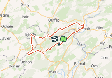
![](/images/other/stat-length.png)
![Randonnée V.T.T. Durbuy - Circuit VTT Durbuy (Houmart) - La Vallée du Néblon - Photo](https://media.geolcdn.com/t/1900/400/ext.pjpeg?maxdim=2&url=https%3A%2F%2Fpivotmedia.tourismewallonie.be%2FOTH-A0-0059-1GTQ%2FOTH-A0-0059-1GTQ.jpg)
Circuit VTT Durbuy (Houmart) - La Vallée du Néblon
Commissariat général au Tourisme
Randonnées du CGT GUIDE+
![Longueur](/images/other/stat-length.png)
![Altitude max](https://static1.geolcdn.com/siteimages/upload/files/1508320355ic_sort_altitude_max_24dp.png)
![Dénivelé positif](https://static1.geolcdn.com/siteimages/upload/files/1508320355ic_sort_den_pos_24dp.png)
![Km-Effort](/images/other/stat-length.png)
![Altitude min](https://static1.geolcdn.com/siteimages/upload/files/1508320355ic_sort_altitude_min_24dp.png)
![Dénivelé négatif](https://static1.geolcdn.com/siteimages/upload/files/1508320355ic_sort_den_neg_24dp.png)
![Boucle](https://static1.geolcdn.com/siteimages/upload/files/16400158638029165_repeat_loop_refresh_sync_direction_icon.png)
![V.T.T.](https://static1.geolcdn.com/sitytour/trail-icons/202.png)
2h19
Difficulté : Difficile
![Scannez ce code QR pour ouvrir la randonnée dans l'application SityTrail](https://capi.geolives.com/qq0zvz2zws4bq2lad0pu/sitytour/trails/3080682/qr.png?size=200)
Application GPS de randonnée GRATUITE
À propos
Randonnée V.T.T. de 26 km à découvrir à Wallonie, Luxembourg, Durbuy. Cette randonnée est proposée par Commissariat général au Tourisme.
Description
Randonnée créée par Famenne-Ardenne.
Départ du Hameau de Houmart pour vous emmener à la découverte des grandes étendues du Condroz tout en vous invitant à découvrir les merveilles de la vallée du Néblon.
Site web: https://organismes.tourismewallonie.be/details/ITB-01-000A93&type=8/
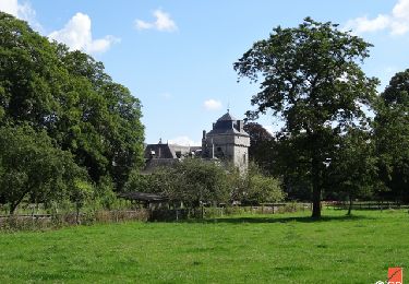
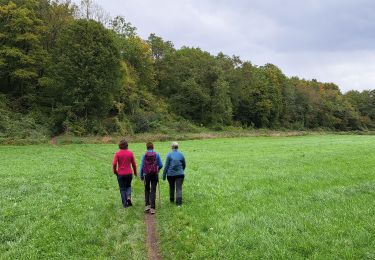
Localisation
Commentaires
Randonnées à proximité
![Randonnée Marche Hamoir - RB-Lg-19_Hamoir - Photo](https://media.geolcdn.com/t/375/260/ext.jpg?maxdim=2&url=https%3A%2F%2Fservices.sitytrail.com%2FGeolivesWS%2FDownloadMedia.ashx%3FTrailID%3D400602%26Media%3Dc0745639-8ded-479e-9345-a8c68cd61e6a.jpg)
![Marche Marche](https://static1.geolcdn.com/sitytour/trail-icons/101.png)
Marche
![](/images/other/stat-length.png)
![](https://static1.geolcdn.com/siteimages/upload/files/16400158638029165_repeat_loop_refresh_sync_direction_icon.png)
![Randonnée Marche Durbuy - RB-Lu-01_Tohogne - Photo](https://media.geolcdn.com/t/375/260/ext.jpg?maxdim=2&url=https%3A%2F%2Fservices.sitytrail.com%2FGeolivesWS%2FDownloadMedia.ashx%3FTrailID%3D179610%26Media%3Dbae66ec4-955f-4295-8f2d-e1b21fcea213.jpg)
![Marche Marche](https://static1.geolcdn.com/sitytour/trail-icons/101.png)
Marche
![](/images/other/stat-length.png)
![](https://static1.geolcdn.com/siteimages/upload/files/16400158638029165_repeat_loop_refresh_sync_direction_icon.png)
![Randonnée Marche Durbuy - Balade à Bomal sur Ourthe - Photo](https://media.geolcdn.com/t/375/260/5741dd62-7ff1-40d2-b9aa-0e0aed97da9a.jpg&format=jpg&maxdim=2)
![Marche Marche](https://static1.geolcdn.com/sitytour/trail-icons/101.png)
Marche
![](/images/other/stat-length.png)
![](https://static1.geolcdn.com/siteimages/upload/files/16400158638029165_repeat_loop_refresh_sync_direction_icon.png)
![Randonnée Marche Hamoir - HAMOIR (Vallée du Neblon) - Photo](https://media.geolcdn.com/t/375/260/bd133f9f-5595-47e8-88c0-4d09e83d3ba8.jpg&format=jpg&maxdim=2)
![Marche Marche](https://static1.geolcdn.com/sitytour/trail-icons/101.png)
Marche
![](/images/other/stat-length.png)
![](https://static1.geolcdn.com/siteimages/upload/files/16400158638029165_repeat_loop_refresh_sync_direction_icon.png)
![Randonnée Marche Ferrières - RL-GG-15_Sy_Barvaux - Photo](https://media.geolcdn.com/t/375/260/4cf6fb9a-77d5-4c51-bb72-4b6ca6a27202.jpg&format=jpg&maxdim=2)
![Marche Marche](https://static1.geolcdn.com/sitytour/trail-icons/101.png)
Marche
![](/images/other/stat-length.png)
![](https://static1.geolcdn.com/siteimages/upload/files/16400158638029165_repeat_loop_refresh_sync_direction_icon.png)
![Randonnée Marche Durbuy - Autour de Tohogne (Durbuy) - Photo](https://media.geolcdn.com/t/375/260/2a8689fc-6e11-44ce-8f89-67705d1757ba.jpg&format=jpg&maxdim=2)
![Marche Marche](https://static1.geolcdn.com/sitytour/trail-icons/101.png)
Marche
![](/images/other/stat-length.png)
![](https://static1.geolcdn.com/siteimages/upload/files/16400158638029165_repeat_loop_refresh_sync_direction_icon.png)
![Marche Marche](https://static1.geolcdn.com/sitytour/trail-icons/101.png)
Marche
![](/images/other/stat-length.png)
![](https://static1.geolcdn.com/siteimages/upload/files/16400158638029165_repeat_loop_refresh_sync_direction_icon.png)
![Randonnée Marche Hamoir - Hamoir - Sy - Les Crêtes - Photo](https://media.geolcdn.com/t/375/260/2cd3e10e-e069-4884-9433-cbc8b49962aa.jpg&format=jpg&maxdim=2)
![Marche Marche](https://static1.geolcdn.com/sitytour/trail-icons/101.png)
Marche
![](/images/other/stat-length.png)
![](https://static1.geolcdn.com/siteimages/upload/files/16400158638029165_repeat_loop_refresh_sync_direction_icon.png)
![Randonnée Marche Ouffet - ouffet fermes ac + - Photo](https://media.geolcdn.com/t/375/260/fd6ab0a5-da2e-4ec4-9fa1-96c42c21280a.jpg&format=jpg&maxdim=2)
![Marche Marche](https://static1.geolcdn.com/sitytour/trail-icons/101.png)
Marche
![](/images/other/stat-length.png)
![](https://static1.geolcdn.com/siteimages/upload/files/16400158638029165_repeat_loop_refresh_sync_direction_icon.png)