![](/images/other/stat-length.png)
Stoumont | P9 Promenade des sources
Commissariat général au Tourisme
Randonnées du CGT GUIDE+
![Longueur](/images/other/stat-length.png)
![Altitude max](https://static1.geolcdn.com/siteimages/upload/files/1508320355ic_sort_altitude_max_24dp.png)
![Dénivelé positif](https://static1.geolcdn.com/siteimages/upload/files/1508320355ic_sort_den_pos_24dp.png)
![Km-Effort](/images/other/stat-length.png)
![Altitude min](https://static1.geolcdn.com/siteimages/upload/files/1508320355ic_sort_altitude_min_24dp.png)
![Dénivelé négatif](https://static1.geolcdn.com/siteimages/upload/files/1508320355ic_sort_den_neg_24dp.png)
![Boucle](https://static1.geolcdn.com/siteimages/upload/files/16400158638029165_repeat_loop_refresh_sync_direction_icon.png)
![A pied](https://static1.geolcdn.com/sitytour/trail-icons/100.png)
3h14
Difficulté : Facile
![Scannez ce code QR pour ouvrir la randonnée dans l'application SityTrail](https://capi.geolives.com/qq0zvz2zws4bq2lad0pu/sitytour/trails/3080510/qr.png?size=200)
Application GPS de randonnée GRATUITE
À propos
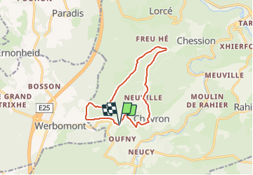
Randonnée A pied de 10,6 km à découvrir à Wallonie, Liège, Stoumont. Cette randonnée est proposée par Commissariat général au Tourisme.
Description
Randonnée créée par Ourthe Vesdre Amblève.
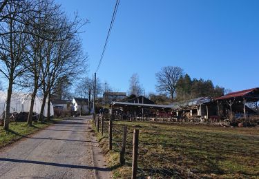
La promenade des sources nous fait découvrir la magnifique vallée de Bru, où se trouvent les sources qui ont fait le renom de Chevron. L’eau de Bru est connue depuis l’époque romaine et commercialisée depuis le 17e siècle. On peut apercevoir en se promenant les anciennes installations de mise en bouteilles. La nouvelle usine a été déplacée près de l’autoroute, rendant au vallon un charme sauvage.
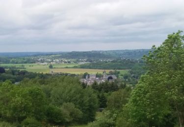
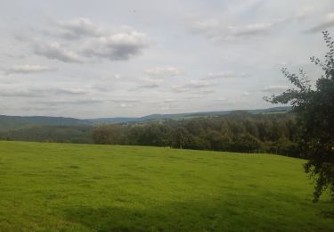
L’itinéraire, au cœur de la forêt ardennaise fait découvrir de nombreux paysages : basse et haute vallée de la Lienne, crêtes surplombant l’Amblève, petits villages nichés en bordure des bois… Dépaysement, charme et magie sont ici au rendez-vous.
Site web: https://ovatourisme.be/details/ITB-0W-01BL-00N7&type=8/
Localisation
Commentaires
Randonnées à proximité
![Randonnée Marche Stoumont - Lorcé, Natura 2000 - Des sites qui valent le détour, Lg13 - Photo](https://media.geolcdn.com/t/375/260/ext.jpg?maxdim=2&url=https%3A%2F%2Fservices.sitytrail.com%2FGeolivesWS%2FDownloadMedia.ashx%3FTrailID%3D182859%26Media%3D43b80b1e-327b-4d3e-accc-f8b9c8a445c2.JPG)
![Marche Marche](https://static1.geolcdn.com/sitytour/trail-icons/101.png)
Marche
![](/images/other/stat-length.png)
![](https://static1.geolcdn.com/siteimages/upload/files/16400158638029165_repeat_loop_refresh_sync_direction_icon.png)
![Randonnée Marche Stoumont - RB-Lg-14_Chevron_via-racc - Photo](https://media.geolcdn.com/t/375/260/ext.jpg?maxdim=2&url=https%3A%2F%2Fservices.sitytrail.com%2FGeolivesWS%2FDownloadMedia.ashx%3FTrailID%3D179572%26Media%3Ddd649bf1-a115-4c1e-9e23-c1a80ab51103.jpg)
![Marche Marche](https://static1.geolcdn.com/sitytour/trail-icons/101.png)
Marche
![](/images/other/stat-length.png)
![](https://static1.geolcdn.com/siteimages/upload/files/16400158638029165_repeat_loop_refresh_sync_direction_icon.png)
![Randonnée Marche Stoumont - Stoumont - P14 Promenade des sommets de la Lienne - Photo](https://media.geolcdn.com/t/375/260/a2987c7f-4dfa-4904-87e7-be0c835ea8dd.jpg&format=jpg&maxdim=2)
![Marche Marche](https://static1.geolcdn.com/sitytour/trail-icons/101.png)
Marche
![](/images/other/stat-length.png)
![](https://static1.geolcdn.com/siteimages/upload/files/16400158638029165_repeat_loop_refresh_sync_direction_icon.png)
![Randonnée Marche Stoumont - lorcé . suf la lienne . Chevron . lorcé - Photo](https://media.geolcdn.com/t/375/260/9599f201-d2ad-4521-ad0a-b4661e5a5ff4.jpg&format=jpg&maxdim=2)
![Marche Marche](https://static1.geolcdn.com/sitytour/trail-icons/101.png)
Marche
![](/images/other/stat-length.png)
![](https://static1.geolcdn.com/siteimages/upload/files/16400158638029165_repeat_loop_refresh_sync_direction_icon.png)
![Randonnée Marche Aywaille - houssonloge . bois du pouhon . trou de bosson . paradis . houssonloge - Photo](https://media.geolcdn.com/t/375/260/8bc033a3-d4f5-4c9f-9bb4-a2d3fb614b59.jpg&format=jpg&maxdim=2)
![Marche Marche](https://static1.geolcdn.com/sitytour/trail-icons/101.png)
Marche
![](/images/other/stat-length.png)
![](https://static1.geolcdn.com/siteimages/upload/files/16400158638029165_repeat_loop_refresh_sync_direction_icon.png)
![Randonnée Marche Stoumont - RB-Lg-14_Chevron - Photo](https://media.geolcdn.com/t/375/260/ext.jpg?maxdim=2&url=https%3A%2F%2Fservices.sitytrail.com%2FGeolivesWS%2FDownloadMedia.ashx%3FTrailID%3D179572%26Media%3Ddd649bf1-a115-4c1e-9e23-c1a80ab51103.jpg)
![Marche Marche](https://static1.geolcdn.com/sitytour/trail-icons/101.png)
Marche
![](/images/other/stat-length.png)
![](https://static1.geolcdn.com/siteimages/upload/files/16400158638029165_repeat_loop_refresh_sync_direction_icon.png)
![Randonnée Marche Stoumont - 10km sous la pluie autour de Lorcé - Photo](https://media.geolcdn.com/t/375/260/cbc0016a-dfca-4c73-9974-c42c5bf54007.jpg&format=jpg&maxdim=2)
![Marche Marche](https://static1.geolcdn.com/sitytour/trail-icons/101.png)
Marche
![](/images/other/stat-length.png)
![](https://static1.geolcdn.com/siteimages/upload/files/16400158638029165_repeat_loop_refresh_sync_direction_icon.png)
![Randonnée Marche Stoumont - ST12 Lorcé . Chession . Lorcé - Photo](https://media.geolcdn.com/t/375/260/4fb5fd46-a2f8-4332-bf19-91c606197682.jpg&format=jpg&maxdim=2)
![Marche Marche](https://static1.geolcdn.com/sitytour/trail-icons/101.png)
Marche
![](/images/other/stat-length.png)
![](https://static1.geolcdn.com/siteimages/upload/files/16400158638029165_repeat_loop_refresh_sync_direction_icon.png)
![Randonnée Marche Stoumont - Tour Lorcé Chevron - Photo](https://media.geolcdn.com/t/375/260/6a4a07e0-645e-4567-8da1-cb8239aaf8df.jpg&format=jpg&maxdim=2)
![Marche Marche](https://static1.geolcdn.com/sitytour/trail-icons/101.png)
Marche
![](/images/other/stat-length.png)
![](https://static1.geolcdn.com/siteimages/upload/files/16400158638029165_repeat_loop_refresh_sync_direction_icon.png)