![](/images/other/stat-length.png)
![Randonnée A pied Stoumont - Stoumont | P7 Promenade du Gué - Photo](https://media.geolcdn.com/t/1900/400/ext.pjpeg?maxdim=2&url=https%3A%2F%2Fpivotmedia.tourismewallonie.be%2FANX-0W-01F9-003W%2FANX-0W-01F9-003W.jpg)
Stoumont | P7 Promenade du Gué
Commissariat général au Tourisme
Randonnées du CGT GUIDE+
![Longueur](/images/other/stat-length.png)
![Altitude max](https://static1.geolcdn.com/siteimages/upload/files/1508320355ic_sort_altitude_max_24dp.png)
![Dénivelé positif](https://static1.geolcdn.com/siteimages/upload/files/1508320355ic_sort_den_pos_24dp.png)
![Km-Effort](/images/other/stat-length.png)
![Altitude min](https://static1.geolcdn.com/siteimages/upload/files/1508320355ic_sort_altitude_min_24dp.png)
![Dénivelé négatif](https://static1.geolcdn.com/siteimages/upload/files/1508320355ic_sort_den_neg_24dp.png)
![Boucle](https://static1.geolcdn.com/siteimages/upload/files/16400158638029165_repeat_loop_refresh_sync_direction_icon.png)
![A pied](https://static1.geolcdn.com/sitytour/trail-icons/100.png)
2h07
Difficulté : Facile
![Scannez ce code QR pour ouvrir la randonnée dans l'application SityTrail](https://capi.geolives.com/qq0zvz2zws4bq2lad0pu/sitytour/trails/3080507/qr.png?size=200)
Application GPS de randonnée GRATUITE
À propos
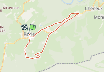
Randonnée A pied de 7,2 km à découvrir à Wallonie, Liège, Stoumont. Cette randonnée est proposée par Commissariat général au Tourisme.
Description
Randonnée créée par Ourthe Vesdre Amblève.
Après la traversée du village de Rahier, le circuit se prolonge en forêt avec un passage du gué dans la petite vallée du Hornay. Traversée d’une partie du village de Cheneux et retour à Rahier.
Site web: https://ovatourisme.be/details/ITB-0W-01BL-00BM&type=8/
Localisation
Commentaires
Randonnées à proximité
![Randonnée Marche Stoumont - Lorcé, Natura 2000 - Des sites qui valent le détour, Lg13 - Photo](https://media.geolcdn.com/t/375/260/ext.jpg?maxdim=2&url=https%3A%2F%2Fservices.sitytrail.com%2FGeolivesWS%2FDownloadMedia.ashx%3FTrailID%3D182859%26Media%3D43b80b1e-327b-4d3e-accc-f8b9c8a445c2.JPG)
![Marche Marche](https://static1.geolcdn.com/sitytour/trail-icons/101.png)
Marche
![](/images/other/stat-length.png)
![](https://static1.geolcdn.com/siteimages/upload/files/16400158638029165_repeat_loop_refresh_sync_direction_icon.png)
![Randonnée Marche Stoumont - RB-Lg-14_Chevron_via-racc - Photo](https://media.geolcdn.com/t/375/260/ext.jpg?maxdim=2&url=https%3A%2F%2Fservices.sitytrail.com%2FGeolivesWS%2FDownloadMedia.ashx%3FTrailID%3D179572%26Media%3Ddd649bf1-a115-4c1e-9e23-c1a80ab51103.jpg)
![Marche Marche](https://static1.geolcdn.com/sitytour/trail-icons/101.png)
Marche
![](/images/other/stat-length.png)
![](https://static1.geolcdn.com/siteimages/upload/files/16400158638029165_repeat_loop_refresh_sync_direction_icon.png)
![Randonnée Marche Stoumont - RB-Lg-13_Stoumont - Photo](https://media.geolcdn.com/t/375/260/ext.jpg?maxdim=2&url=https%3A%2F%2Fservices.sitytrail.com%2FGeolivesWS%2FDownloadMedia.ashx%3FTrailID%3D179571%26Media%3Dfca3b0ca-06fe-45d6-8ded-857ea27270cf.jpg)
![Marche Marche](https://static1.geolcdn.com/sitytour/trail-icons/101.png)
Marche
![](/images/other/stat-length.png)
![](https://static1.geolcdn.com/siteimages/upload/files/16400158638029165_repeat_loop_refresh_sync_direction_icon.png)
![Randonnée Marche Stoumont - Stoumont - P14 Promenade des sommets de la Lienne - Photo](https://media.geolcdn.com/t/375/260/a2987c7f-4dfa-4904-87e7-be0c835ea8dd.jpg&format=jpg&maxdim=2)
![Marche Marche](https://static1.geolcdn.com/sitytour/trail-icons/101.png)
Marche
![](/images/other/stat-length.png)
![](https://static1.geolcdn.com/siteimages/upload/files/16400158638029165_repeat_loop_refresh_sync_direction_icon.png)
![Randonnée Marche Stoumont - La Gleize - P3 - Tour du Mont Saint-Victor - Photo](https://media.geolcdn.com/t/375/260/eeda461f-0b98-4912-915c-63b0e2025382.jpg&format=jpg&maxdim=2)
![Marche Marche](https://static1.geolcdn.com/sitytour/trail-icons/101.png)
Marche
![](/images/other/stat-length.png)
![](https://static1.geolcdn.com/siteimages/upload/files/16400158638029165_repeat_loop_refresh_sync_direction_icon.png)
![Randonnée Marche Stoumont - lorcé . suf la lienne . Chevron . lorcé - Photo](https://media.geolcdn.com/t/375/260/9599f201-d2ad-4521-ad0a-b4661e5a5ff4.jpg&format=jpg&maxdim=2)
![Marche Marche](https://static1.geolcdn.com/sitytour/trail-icons/101.png)
Marche
![](/images/other/stat-length.png)
![](https://static1.geolcdn.com/siteimages/upload/files/16400158638029165_repeat_loop_refresh_sync_direction_icon.png)
![Randonnée Marche Stoumont - RB-Lg-14_Chevron - Photo](https://media.geolcdn.com/t/375/260/ext.jpg?maxdim=2&url=https%3A%2F%2Fservices.sitytrail.com%2FGeolivesWS%2FDownloadMedia.ashx%3FTrailID%3D179572%26Media%3Ddd649bf1-a115-4c1e-9e23-c1a80ab51103.jpg)
![Marche Marche](https://static1.geolcdn.com/sitytour/trail-icons/101.png)
Marche
![](/images/other/stat-length.png)
![](https://static1.geolcdn.com/siteimages/upload/files/16400158638029165_repeat_loop_refresh_sync_direction_icon.png)
![Randonnée Marche Stoumont - 10km sous la pluie autour de Lorcé - Photo](https://media.geolcdn.com/t/375/260/cbc0016a-dfca-4c73-9974-c42c5bf54007.jpg&format=jpg&maxdim=2)
![Marche Marche](https://static1.geolcdn.com/sitytour/trail-icons/101.png)
Marche
![](/images/other/stat-length.png)
![](https://static1.geolcdn.com/siteimages/upload/files/16400158638029165_repeat_loop_refresh_sync_direction_icon.png)
![Randonnée Marche Stoumont - ST12 Lorcé . Chession . Lorcé - Photo](https://media.geolcdn.com/t/375/260/4fb5fd46-a2f8-4332-bf19-91c606197682.jpg&format=jpg&maxdim=2)
![Marche Marche](https://static1.geolcdn.com/sitytour/trail-icons/101.png)
Marche
![](/images/other/stat-length.png)
![](https://static1.geolcdn.com/siteimages/upload/files/16400158638029165_repeat_loop_refresh_sync_direction_icon.png)