![](/images/other/stat-length.png)
![Randonnée A pied Arlon - De Sesselich et Wolkrange accessible à tous - Photo](https://media.geolcdn.com/t/1900/400/ext.pjpeg?maxdim=2&url=https%3A%2F%2Fpivotmedia.tourismewallonie.be%2FOTH-A0-0067-0QTR%2FOTH-A0-0067-0QTR.jpg)
De Sesselich et Wolkrange accessible à tous
Commissariat général au Tourisme
Randonnées du CGT GUIDE+
![Longueur](/images/other/stat-length.png)
![Altitude max](https://static1.geolcdn.com/siteimages/upload/files/1508320355ic_sort_altitude_max_24dp.png)
![Dénivelé positif](https://static1.geolcdn.com/siteimages/upload/files/1508320355ic_sort_den_pos_24dp.png)
![Km-Effort](/images/other/stat-length.png)
![Altitude min](https://static1.geolcdn.com/siteimages/upload/files/1508320355ic_sort_altitude_min_24dp.png)
![Dénivelé négatif](https://static1.geolcdn.com/siteimages/upload/files/1508320355ic_sort_den_neg_24dp.png)
![Boucle](https://static1.geolcdn.com/siteimages/upload/files/16400158638029165_repeat_loop_refresh_sync_direction_icon.png)
![A pied](https://static1.geolcdn.com/sitytour/trail-icons/100.png)
2h09
Difficulté : Facile
![Scannez ce code QR pour ouvrir la randonnée dans l'application SityTrail](https://capi.geolives.com/qq0zvz2zws4bq2lad0pu/sitytour/trails/3080379/qr.png?size=200)
Application GPS de randonnée GRATUITE
À propos
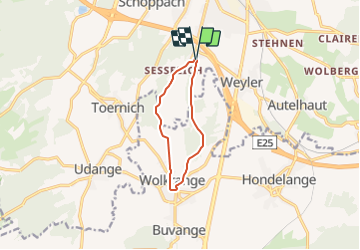
Randonnée A pied de 7,6 km à découvrir à Wallonie, Luxembourg, Arlon. Cette randonnée est proposée par Commissariat général au Tourisme.
Description
Randonnée créée par Pays d'Arlon.
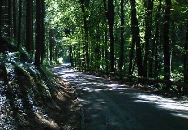
Itinéraire facile et accessible en poussette, entre campagne et bois, entre étangs de Wolkrange et vallon sauvage au retour.
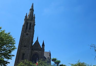
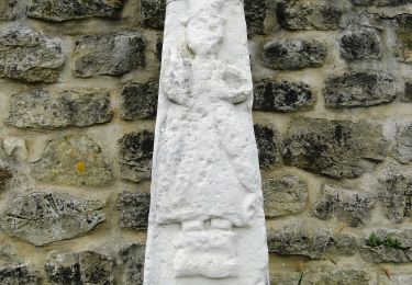
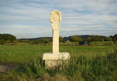
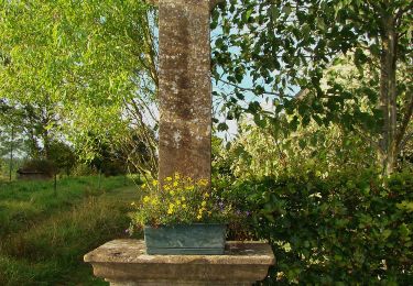
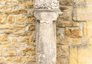
Vous découvrirez l'architecture typique de la région à travers l'ancien lavoir à Wolkrange et au centre de Sesselich, la petite chapelle Saint-Rombaut et une belle ferme en carré semi-cloîtrée du 18e siècle.
Site web: https://organismes.tourismewallonie.be/details/ITB-01-000A3C&type=8/
Localisation
Commentaires
Randonnées à proximité
![Randonnée Marche Arlon - Guirsch, vallée des moulins - Photo](https://media.geolcdn.com/t/375/260/ext.jpg?maxdim=2&url=https%3A%2F%2Fservices.sitytrail.com%2FGeolivesWS%2FDownloadMedia.ashx%3FTrailID%3D462490%26Media%3Dfix__20150822151852.jpg)
![Marche Marche](https://static1.geolcdn.com/sitytour/trail-icons/101.png)
Marche
![](/images/other/stat-length.png)
![](https://static1.geolcdn.com/siteimages/upload/files/16400158638029165_repeat_loop_refresh_sync_direction_icon.png)
![Randonnée Marche Arlon - 31.265 Arlon - Vieille Ville - Photo](https://media.geolcdn.com/t/375/260/6e3c8fe1-1a08-4d78-ab40-dbec45946f7d.jpg&format=jpg&maxdim=2)
![Marche Marche](https://static1.geolcdn.com/sitytour/trail-icons/101.png)
Marche
![](/images/other/stat-length.png)
![](https://static1.geolcdn.com/siteimages/upload/files/16400158638029165_repeat_loop_refresh_sync_direction_icon.png)
![Randonnée Marche Arlon - Arlon - MESA 2024 - Photo](https://media.geolcdn.com/t/375/260/92382029-15cc-4d2e-a284-1e722105163a.jpg&format=jpg&maxdim=2)
![Marche Marche](https://static1.geolcdn.com/sitytour/trail-icons/101.png)
Marche
![](/images/other/stat-length.png)
![](https://static1.geolcdn.com/siteimages/upload/files/16400158638029165_repeat_loop_refresh_sync_direction_icon.png)
![Randonnée A pied Arlon - N° 8 - Waltzing-Eischen, balade belgo-luxembourgeoise - Photo](https://media.geolcdn.com/t/375/260/b0eed337-7084-4191-bc62-985346659136.jpeg&format=jpg&maxdim=2)
![A pied A pied](https://static1.geolcdn.com/sitytour/trail-icons/100.png)
A pied
![](/images/other/stat-length.png)
![](https://static1.geolcdn.com/siteimages/upload/files/16400158638029165_repeat_loop_refresh_sync_direction_icon.png)
![Randonnée A pied Arlon - N° 2 - De Sesselich à Wolkrange - Photo](https://media.geolcdn.com/t/375/260/76977e4f-2882-4817-b7e6-b3bc029201a9.jpeg&format=jpg&maxdim=2)
![A pied A pied](https://static1.geolcdn.com/sitytour/trail-icons/100.png)
A pied
![](/images/other/stat-length.png)
![](https://static1.geolcdn.com/siteimages/upload/files/16400158638029165_repeat_loop_refresh_sync_direction_icon.png)
![Randonnée A pied Arlon - N° 5 - Udange - Au cœur de la forêt primitive - Photo](https://media.geolcdn.com/t/375/260/256ffff4-9371-48c3-8e4d-7f2e673b9ec6.jpeg&format=jpg&maxdim=2)
![A pied A pied](https://static1.geolcdn.com/sitytour/trail-icons/100.png)
A pied
![](/images/other/stat-length.png)
![](https://static1.geolcdn.com/siteimages/upload/files/16400158638029165_repeat_loop_refresh_sync_direction_icon.png)
![Randonnée Marche Arlon - Arlon - Toernich - Arlon (2012 11 04 ) - Photo](https://media.geolcdn.com/t/375/260/ext.jpg?maxdim=2&url=https%3A%2F%2Fstatic1.geolcdn.com%2Fsiteimages%2Fupload%2Ffiles%2F1553511878bg_sport_marche.png)
![Marche Marche](https://static1.geolcdn.com/sitytour/trail-icons/101.png)
Marche
![](/images/other/stat-length.png)
![](https://static1.geolcdn.com/siteimages/upload/files/16400158638029165_repeat_loop_refresh_sync_direction_icon.png)
![Randonnée Marche Arlon - Arlon Mesa 250624 - Photo](https://media.geolcdn.com/t/375/260/d81e4acf-04b8-4786-a503-bbafb6326ef4.jpg&format=jpg&maxdim=2)
![Marche Marche](https://static1.geolcdn.com/sitytour/trail-icons/101.png)
Marche
![](/images/other/stat-length.png)
![](https://static1.geolcdn.com/siteimages/upload/files/16400158638029165_repeat_loop_refresh_sync_direction_icon.png)
![Randonnée A pied Messancy - Promenade de Sélange - Photo](https://media.geolcdn.com/t/375/260/364577a5-2624-42cc-a06b-891df7310020.jpeg&format=jpg&maxdim=2)
![A pied A pied](https://static1.geolcdn.com/sitytour/trail-icons/100.png)
A pied
![](/images/other/stat-length.png)
![](https://static1.geolcdn.com/siteimages/upload/files/16400158638029165_repeat_loop_refresh_sync_direction_icon.png)