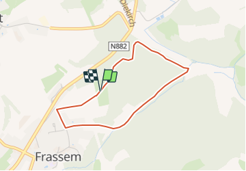
![](/images/other/stat-length.png)
![Randonnée A pied Arlon - L'Arboretum de Frassem - Photo](https://media.geolcdn.com/t/1900/400/ext.pjpeg?maxdim=2&url=https%3A%2F%2Fpivotmedia.tourismewallonie.be%2FOTH-A0-0067-0PTQ%2FOTH-A0-0067-0PTQ.jpg)
L'Arboretum de Frassem
Commissariat général au Tourisme
Randonnées du CGT GUIDE+
![Longueur](/images/other/stat-length.png)
![Altitude max](https://static1.geolcdn.com/siteimages/upload/files/1508320355ic_sort_altitude_max_24dp.png)
![Dénivelé positif](https://static1.geolcdn.com/siteimages/upload/files/1508320355ic_sort_den_pos_24dp.png)
![Km-Effort](/images/other/stat-length.png)
![Altitude min](https://static1.geolcdn.com/siteimages/upload/files/1508320355ic_sort_altitude_min_24dp.png)
![Dénivelé négatif](https://static1.geolcdn.com/siteimages/upload/files/1508320355ic_sort_den_neg_24dp.png)
![Boucle](https://static1.geolcdn.com/siteimages/upload/files/16400158638029165_repeat_loop_refresh_sync_direction_icon.png)
![A pied](https://static1.geolcdn.com/sitytour/trail-icons/100.png)
54m
Difficulté : Facile
![Scannez ce code QR pour ouvrir la randonnée dans l'application SityTrail](https://capi.geolives.com/qq0zvz2zws4bq2lad0pu/sitytour/trails/3080367/qr.png?size=200)
Application GPS de randonnée GRATUITE
À propos
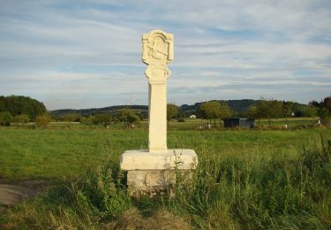
Randonnée A pied de 3,1 km à découvrir à Wallonie, Luxembourg, Arlon. Cette randonnée est proposée par Commissariat général au Tourisme.
Description
Randonnée créée par Pays d'Arlon.
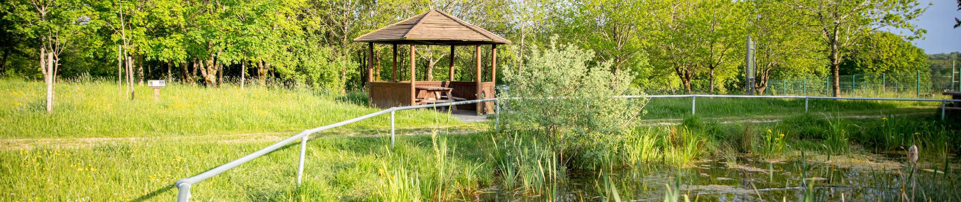
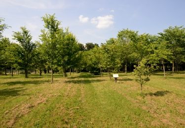
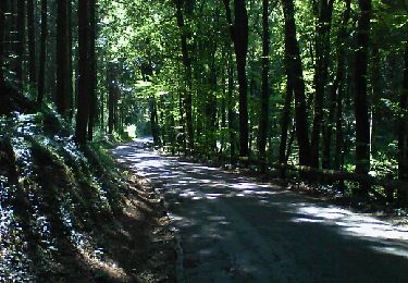
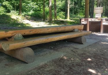
L'Arboretum et sa promenade vous invitent à mieux connaître plus de 50 espèces d'arbres et buissons de nos régions. Avec sa mare, ses nichoirs, son hôtel à insectes et ses ruches, il favorise la vie sauvage des insectes, des plantes et des oiseaux. Une balade toute verte, entre nature et découverte ! Kiosque et table à disposition, pour un moment didactique ou un bon pique-nique !
Site web: https://organismes.tourismewallonie.be/details/ITB-01-000A35&type=8/
Localisation
Commentaires
Randonnées à proximité
![Randonnée Marche Arlon - Clairefontaine - Circuit Natura 2000, des sites qui valent le détour - Lx15 - Photo](https://media.geolcdn.com/t/375/260/ext.jpg?maxdim=2&url=https%3A%2F%2Fservices.sitytrail.com%2FGeolivesWS%2FDownloadMedia.ashx%3FTrailID%3D333331%26Media%3D011bab6f-c149-41bf-be76-696578f9f696.JPG)
![Marche Marche](https://static1.geolcdn.com/sitytour/trail-icons/101.png)
Marche
![](/images/other/stat-length.png)
![](https://static1.geolcdn.com/siteimages/upload/files/16400158638029165_repeat_loop_refresh_sync_direction_icon.png)
![Randonnée Marche Arlon - Guirsch, vallée des moulins - Photo](https://media.geolcdn.com/t/375/260/ext.jpg?maxdim=2&url=https%3A%2F%2Fservices.sitytrail.com%2FGeolivesWS%2FDownloadMedia.ashx%3FTrailID%3D462490%26Media%3Dfix__20150822151852.jpg)
![Marche Marche](https://static1.geolcdn.com/sitytour/trail-icons/101.png)
Marche
![](/images/other/stat-length.png)
![](https://static1.geolcdn.com/siteimages/upload/files/16400158638029165_repeat_loop_refresh_sync_direction_icon.png)
![Randonnée Marche Arlon - 31.265 Arlon - Vieille Ville - Photo](https://media.geolcdn.com/t/375/260/6e3c8fe1-1a08-4d78-ab40-dbec45946f7d.jpg&format=jpg&maxdim=2)
![Marche Marche](https://static1.geolcdn.com/sitytour/trail-icons/101.png)
Marche
![](/images/other/stat-length.png)
![](https://static1.geolcdn.com/siteimages/upload/files/16400158638029165_repeat_loop_refresh_sync_direction_icon.png)
![Randonnée Marche Habscht - Tunnel Tour - Photo](https://media.geolcdn.com/t/375/260/82720245-2ef9-4a0b-a9f7-0bd828756b2c.jpg&format=jpg&maxdim=2)
![Marche Marche](https://static1.geolcdn.com/sitytour/trail-icons/101.png)
Marche
![](/images/other/stat-length.png)
![](https://static1.geolcdn.com/siteimages/upload/files/16400158638029165_repeat_loop_refresh_sync_direction_icon.png)
![Randonnée Marche Arlon - RF-Lu-15 - Une randonnée (trans)frontalière : Clairefontaine - Photo](https://media.geolcdn.com/t/375/260/ext.jpg?maxdim=2&url=https%3A%2F%2Fstatic1.geolcdn.com%2Fsiteimages%2Fupload%2Ffiles%2F1553511878bg_sport_marche.png)
![Marche Marche](https://static1.geolcdn.com/sitytour/trail-icons/101.png)
Marche
![](/images/other/stat-length.png)
![](https://static1.geolcdn.com/siteimages/upload/files/16400158638029165_repeat_loop_refresh_sync_direction_icon.png)
![Randonnée Marche Arlon - Arlon - MESA 2024 - Photo](https://media.geolcdn.com/t/375/260/92382029-15cc-4d2e-a284-1e722105163a.jpg&format=jpg&maxdim=2)
![Marche Marche](https://static1.geolcdn.com/sitytour/trail-icons/101.png)
Marche
![](/images/other/stat-length.png)
![](https://static1.geolcdn.com/siteimages/upload/files/16400158638029165_repeat_loop_refresh_sync_direction_icon.png)
![Randonnée A pied Arlon - N° 8 - Waltzing-Eischen, balade belgo-luxembourgeoise - Photo](https://media.geolcdn.com/t/375/260/b0eed337-7084-4191-bc62-985346659136.jpeg&format=jpg&maxdim=2)
![A pied A pied](https://static1.geolcdn.com/sitytour/trail-icons/100.png)
A pied
![](/images/other/stat-length.png)
![](https://static1.geolcdn.com/siteimages/upload/files/16400158638029165_repeat_loop_refresh_sync_direction_icon.png)
![Randonnée A pied Arlon - Bonnert et la Platinerie - Photo](https://media.geolcdn.com/t/375/260/1d8d5277-2b6d-48c1-89f3-a39930ceda29.jpeg&format=jpg&maxdim=2)
![A pied A pied](https://static1.geolcdn.com/sitytour/trail-icons/100.png)
A pied
![](/images/other/stat-length.png)
![](https://static1.geolcdn.com/siteimages/upload/files/16400158638029165_repeat_loop_refresh_sync_direction_icon.png)
![Randonnée A pied Arlon - N° 2 - De Sesselich à Wolkrange - Photo](https://media.geolcdn.com/t/375/260/76977e4f-2882-4817-b7e6-b3bc029201a9.jpeg&format=jpg&maxdim=2)
![A pied A pied](https://static1.geolcdn.com/sitytour/trail-icons/100.png)
A pied
![](/images/other/stat-length.png)
![](https://static1.geolcdn.com/siteimages/upload/files/16400158638029165_repeat_loop_refresh_sync_direction_icon.png)