![](/images/other/stat-length.png)
![Randonnée V.T.T. Hastière - Heer-Agimont d'une rive à l'autre - Photo](https://media.geolcdn.com/t/1900/400/ext.pjpeg?maxdim=2&url=https%3A%2F%2Fpivotmedia.tourismewallonie.be%2FOTH-A0-0056-33EI%2FOTH-A0-0056-33EI.jpg)
Heer-Agimont d'une rive à l'autre
Commissariat général au Tourisme
Randonnées du CGT GUIDE+
![Longueur](/images/other/stat-length.png)
![Altitude max](https://static1.geolcdn.com/siteimages/upload/files/1508320355ic_sort_altitude_max_24dp.png)
![Dénivelé positif](https://static1.geolcdn.com/siteimages/upload/files/1508320355ic_sort_den_pos_24dp.png)
![Km-Effort](/images/other/stat-length.png)
![Altitude min](https://static1.geolcdn.com/siteimages/upload/files/1508320355ic_sort_altitude_min_24dp.png)
![Dénivelé négatif](https://static1.geolcdn.com/siteimages/upload/files/1508320355ic_sort_den_neg_24dp.png)
![Boucle](https://static1.geolcdn.com/siteimages/upload/files/16400158638029165_repeat_loop_refresh_sync_direction_icon.png)
![V.T.T.](https://static1.geolcdn.com/sitytour/trail-icons/202.png)
1h44
Difficulté : Moyen
![Scannez ce code QR pour ouvrir la randonnée dans l'application SityTrail](https://capi.geolives.com/qq0zvz2zws4bq2lad0pu/sitytour/trails/3080114/qr.png?size=200)
Application GPS de randonnée GRATUITE
À propos
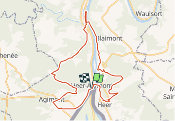
Randonnée V.T.T. de 19,2 km à découvrir à Wallonie, Namur, Hastière. Cette randonnée est proposée par Commissariat général au Tourisme.
Description
Randonnée créée par Vallée de la Meuse Namur-Dinant.
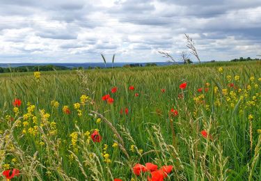
Ce circuit très exigeant explore les deux versants de la vallée mosane en amont d’Hermeton. Au départ de la chapelle Saint-Nicolas à Heer-Agimont, un parcours vallonné vous fait gravir les coteaux du Bois de Bréjoul, puis redescendre vers Hermeton par un tracé très technique. Après avoir franchi l’écluse et le barrage d’Hastière, vous longez la Meuse vers Heer, avant d’effectuer une petite boucle escarpée dans les bois de la rive droite. La descente vous ramène à Heer où vous franchissez le pont pour revenir au point de départ.
A noter que le circuit peut être divisé en 2 parties, en empruntant le RAVeL entre Hermeton et Heer-Agimont pour refermer la boucle, afin de le rendre plus accessible pour les moins chevronnés.
Site web: https://organismes.tourismewallonie.be/details/LOD-A0-003C-0JQY&type=8/
Localisation
Commentaires
Randonnées à proximité
![Randonnée Marche Givet - Balade à Givet - Photo](https://media.geolcdn.com/t/375/260/ext.jpg?maxdim=2&url=https%3A%2F%2Fservices.sitytrail.com%2FGeolivesWS%2FDownloadMedia.ashx%3FTrailID%3D110616%26Media%3D6179_5.jpg)
![Marche Marche](https://static1.geolcdn.com/sitytour/trail-icons/101.png)
![Randonnée Marche Givet - Promenade sur les remparts du Mont d'Haurs - Photo](https://media.geolcdn.com/t/375/260/ext.jpg?maxdim=2&url=https%3A%2F%2Fservices.sitytrail.com%2FGeolivesWS%2FDownloadMedia.ashx%3FTrailID%3D108905%26Media%3D2570_6.jpg)
![Marche Marche](https://static1.geolcdn.com/sitytour/trail-icons/101.png)
Marche
![](/images/other/stat-length.png)
![](https://static1.geolcdn.com/siteimages/upload/files/16400158638029165_repeat_loop_refresh_sync_direction_icon.png)
![Randonnée Marche Hastière - Hastiere, Entre mont et vallée - Photo](https://media.geolcdn.com/t/375/260/068d5622-8276-4255-80ea-e863a3df9f37.jpg&format=jpg&maxdim=2)
![Marche Marche](https://static1.geolcdn.com/sitytour/trail-icons/101.png)
Marche
![](/images/other/stat-length.png)
![](https://static1.geolcdn.com/siteimages/upload/files/16400158638029165_repeat_loop_refresh_sync_direction_icon.png)
![Randonnée Marche Hastière - Waulsort - Circuit Natura 2000, des sites qui valent le détour - Na08 - Photo](https://media.geolcdn.com/t/375/260/ext.jpg?maxdim=2&url=https%3A%2F%2Fservices.sitytrail.com%2FGeolivesWS%2FDownloadMedia.ashx%3FTrailID%3D434736%26Media%3D6da8fd5b-7dc9-4341-8780-4fc280ddf4d9.JPG)
![Marche Marche](https://static1.geolcdn.com/sitytour/trail-icons/101.png)
Marche
![](/images/other/stat-length.png)
![](https://static1.geolcdn.com/siteimages/upload/files/16400158638029165_repeat_loop_refresh_sync_direction_icon.png)
![Randonnée Marche Doische - De Gochenee vers Soulme par la vallee de l'Ermeton - Photo](https://media.geolcdn.com/t/375/260/ext.jpg?maxdim=2&url=https%3A%2F%2Fstatic1.geolcdn.com%2Fsiteimages%2Fupload%2Ffiles%2F1553511878bg_sport_marche.png)
![Marche Marche](https://static1.geolcdn.com/sitytour/trail-icons/101.png)
Marche
![](/images/other/stat-length.png)
![](https://static1.geolcdn.com/siteimages/upload/files/16400158638029165_repeat_loop_refresh_sync_direction_icon.png)
![Randonnée Marche Hastière - Balade à Waulsort - Photo](https://media.geolcdn.com/t/375/260/430266b1-8cd2-4495-b460-1dbc4ae413f0.jpg&format=jpg&maxdim=2)
![Marche Marche](https://static1.geolcdn.com/sitytour/trail-icons/101.png)
Marche
![](/images/other/stat-length.png)
![](https://static1.geolcdn.com/siteimages/upload/files/16400158638029165_repeat_loop_refresh_sync_direction_icon.png)
![Randonnée Marche Hastière - GR RB 11 Namur : Hermeton sur Meuse - Photo](https://media.geolcdn.com/t/375/260/5437211b-2053-42f0-b202-24b3aed8bd65.jpg&format=jpg&maxdim=2)
![Marche Marche](https://static1.geolcdn.com/sitytour/trail-icons/101.png)
Marche
![](/images/other/stat-length.png)
![](https://static1.geolcdn.com/siteimages/upload/files/16400158638029165_repeat_loop_refresh_sync_direction_icon.png)
![Randonnée Marche Houyet - Marche Adeps à Mesnil-Saint-Blaise - Photo](https://media.geolcdn.com/t/375/260/6e90d8be-93ef-4b26-838b-b9d31637f07d.jpeg&format=jpg&maxdim=2)
![Marche Marche](https://static1.geolcdn.com/sitytour/trail-icons/101.png)
Marche
![](/images/other/stat-length.png)
![](https://static1.geolcdn.com/siteimages/upload/files/16400158638029165_repeat_loop_refresh_sync_direction_icon.png)
![Randonnée Marche Doische - De Gochenée à Vodelée par la vallée de l'Hermeton - Photo](https://media.geolcdn.com/t/375/260/143bf095-b327-4de7-bd89-cf3882d0cbb7.jpg&format=jpg&maxdim=2)
![Marche Marche](https://static1.geolcdn.com/sitytour/trail-icons/101.png)
Marche
![](/images/other/stat-length.png)
![](https://static1.geolcdn.com/siteimages/upload/files/16400158638029165_repeat_loop_refresh_sync_direction_icon.png)