![](/images/other/stat-length.png)
![Randonnée Marche Létra - Ternand - Photo](https://media.geolcdn.com/t/1900/400/ext.pjpeg?maxdim=2&url=https%3A%2F%2Fstatic1.geolcdn.com%2Fsiteimages%2Fupload%2Ffiles%2F1553511878bg_sport_marche.png)
Ternand
vidal.galaxy
Utilisateur
![Longueur](/images/other/stat-length.png)
Longueur
19,6 km
![Altitude max](https://static1.geolcdn.com/siteimages/upload/files/1508320355ic_sort_altitude_max_24dp.png)
Altitude max
543 m
![Dénivelé positif](https://static1.geolcdn.com/siteimages/upload/files/1508320355ic_sort_den_pos_24dp.png)
Dénivelé positif
725 m
![Km-Effort](/images/other/stat-length.png)
Km-Effort
29 km
![Altitude min](https://static1.geolcdn.com/siteimages/upload/files/1508320355ic_sort_altitude_min_24dp.png)
Altitude min
274 m
![Dénivelé négatif](https://static1.geolcdn.com/siteimages/upload/files/1508320355ic_sort_den_neg_24dp.png)
Dénivelé négatif
724 m
![Boucle](https://static1.geolcdn.com/siteimages/upload/files/16400158638029165_repeat_loop_refresh_sync_direction_icon.png)
Boucle
Oui
Date de création :
2014-12-10 00:00:00.0
Dernière modification :
2014-12-10 00:00:00.0
![Marche](https://static1.geolcdn.com/sitytour/trail-icons/101.png)
6h03
Difficulté : Moyen
![Scannez ce code QR pour ouvrir la randonnée dans l'application SityTrail](https://capi.geolives.com/qq0zvz2zws4bq2lad0pu/sitytour/trails/307845/qr.png?size=200)
Application GPS de randonnée GRATUITE
À propos
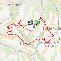
Randonnée Marche de 19,6 km à découvrir à Auvergne-Rhône-Alpes, Rhône, Létra. Cette randonnée est proposée par vidal.galaxy.
Description
Départ de Ternand ( Grandes Planches) pour la chapelle de St laurent, Lambert (Bas et haut), Chatillatard, Létra, chapelle ND de la Salette et Ternand (vieux village)
Localisation
Pays :
France
Région :
Auvergne-Rhône-Alpes
Département/Province :
Rhône
Commune :
Létra
Localité :
Unknown
Départ:(Dec)
Départ:(UTM)
619398 ; 5090719 (31T) N.
Commentaires
Randonnées à proximité
![Randonnée Marche Ternand - Ternand - Létra - Photo](https://media.geolcdn.com/t/375/260/d73b31f3-847d-4c86-9759-810d2e04500a.jpg&format=jpg&maxdim=2)
![Marche Marche](https://static1.geolcdn.com/sitytour/trail-icons/101.png)
Ternand - Létra
Marche
Très difficile
(1)
Ternand,
Auvergne-Rhône-Alpes,
Rhône,
France
![](/images/other/stat-length.png)
17,8 km | 27 km-effort
6h 7min
![](https://static1.geolcdn.com/siteimages/upload/files/16400158638029165_repeat_loop_refresh_sync_direction_icon.png)
Oui
![Randonnée Marche Val d'Oingt - Oingt (69) Beaujolais - Photo](https://media.geolcdn.com/t/375/260/ext.jpg?maxdim=2&url=https%3A%2F%2Fservices.sitytrail.com%2FGeolivesWS%2FDownloadMedia.ashx%3FTrailID%3D717640%26Media%3D20161208145812.jpg)
![Marche Marche](https://static1.geolcdn.com/sitytour/trail-icons/101.png)
Oingt (69) Beaujolais
Marche
Très facile
(1)
Val d'Oingt,
Auvergne-Rhône-Alpes,
Rhône,
France
![](/images/other/stat-length.png)
9,3 km | 13,3 km-effort
2h 30min
![](https://static1.geolcdn.com/siteimages/upload/files/16400158638029165_repeat_loop_refresh_sync_direction_icon.png)
Oui
![Randonnée Marche Saint-Vérand - Saint Vérand - Photo](https://media.geolcdn.com/t/375/260/ext.jpg?maxdim=2&url=https%3A%2F%2Fstatic1.geolcdn.com%2Fsiteimages%2Fupload%2Ffiles%2F1553511878bg_sport_marche.png)
![Marche Marche](https://static1.geolcdn.com/sitytour/trail-icons/101.png)
Saint Vérand
Marche
Moyen
(1)
Saint-Vérand,
Auvergne-Rhône-Alpes,
Rhône,
France
![](/images/other/stat-length.png)
13,5 km | 21 km-effort
3h 37min
![](https://static1.geolcdn.com/siteimages/upload/files/16400158638029165_repeat_loop_refresh_sync_direction_icon.png)
Oui
![Randonnée Marche Dième - Le Ruisseau de Brou - Photo](https://media.geolcdn.com/t/375/260/ext.jpg?maxdim=2&url=https%3A%2F%2Fstatic1.geolcdn.com%2Fsiteimages%2Fupload%2Ffiles%2F1553511878bg_sport_marche.png)
![Marche Marche](https://static1.geolcdn.com/sitytour/trail-icons/101.png)
Le Ruisseau de Brou
Marche
Moyen
(1)
Dième,
Auvergne-Rhône-Alpes,
Rhône,
France
![](/images/other/stat-length.png)
11,3 km | 17,3 km-effort
3h 24min
![](https://static1.geolcdn.com/siteimages/upload/files/16400158638029165_repeat_loop_refresh_sync_direction_icon.png)
Oui
![Randonnée Vélo électrique Val d'Oingt - tour dans le beaujolais Oingt - Salles sur Arbuissonnas - Photo](https://media.geolcdn.com/t/375/260/ext.jpg?maxdim=2&url=https%3A%2F%2Fstatic1.geolcdn.com%2Fsiteimages%2Fupload%2Ffiles%2F1524743154velo.jpg)
![Vélo électrique Vélo électrique](https://static1.geolcdn.com/sitytour/trail-icons/205.png)
tour dans le beaujolais Oingt - Salles sur Arbuissonnas
Vélo électrique
Moyen
(1)
Val d'Oingt,
Auvergne-Rhône-Alpes,
Rhône,
France
![](/images/other/stat-length.png)
52 km | 68 km-effort
5h 44min
![](https://static1.geolcdn.com/siteimages/upload/files/16400158638029165_repeat_loop_refresh_sync_direction_icon.png)
Oui
![Randonnée Marche Sainte-Paule - Sainte-Paule (13,4 km D. 485 m) - Photo](https://media.geolcdn.com/t/375/260/ext.jpg?maxdim=2&url=https%3A%2F%2Fstatic1.geolcdn.com%2Fsiteimages%2Fupload%2Ffiles%2F1553511878bg_sport_marche.png)
![Marche Marche](https://static1.geolcdn.com/sitytour/trail-icons/101.png)
Sainte-Paule (13,4 km D. 485 m)
Marche
Moyen
(1)
Sainte-Paule,
Auvergne-Rhône-Alpes,
Rhône,
France
![](/images/other/stat-length.png)
13,4 km | 19,4 km-effort
4h 9min
![](https://static1.geolcdn.com/siteimages/upload/files/16400158638029165_repeat_loop_refresh_sync_direction_icon.png)
Oui
![Randonnée Marche Val d'Oingt - 69620-StLo-160412-Azergues+Genetière+Berthier - Photo](https://media.geolcdn.com/t/375/260/ext.jpg?maxdim=2&url=https%3A%2F%2Fstatic1.geolcdn.com%2Fsiteimages%2Fupload%2Ffiles%2F1553511878bg_sport_marche.png)
![Marche Marche](https://static1.geolcdn.com/sitytour/trail-icons/101.png)
69620-StLo-160412-Azergues+Genetière+Berthier
Marche
Facile
(2)
Val d'Oingt,
Auvergne-Rhône-Alpes,
Rhône,
France
![](/images/other/stat-length.png)
5,2 km | 7,1 km-effort
1h 38min
![](https://static1.geolcdn.com/siteimages/upload/files/16400158638029165_repeat_loop_refresh_sync_direction_icon.png)
Oui
![Marche Marche](https://static1.geolcdn.com/sitytour/trail-icons/101.png)
Saint-Laurent d'Oingt - Oingt, Plus beau Village de France
Marche
Difficile
Val d'Oingt,
Auvergne-Rhône-Alpes,
Rhône,
France
![](/images/other/stat-length.png)
8,8 km | 12,5 km-effort
2h 20min
![](https://static1.geolcdn.com/siteimages/upload/files/16400158638029165_repeat_loop_refresh_sync_direction_icon.png)
Oui
![Randonnée Marche Val d'Oingt - 69620-Saint-Laurent d'Oingt-Bois d'Oingt : lavoirs, château et coteaux - Photo](https://media.geolcdn.com/t/375/260/f3b7e635-4f2d-4ecb-b5c7-b81cf631e86a.jpg&format=jpg&maxdim=2)
![Marche Marche](https://static1.geolcdn.com/sitytour/trail-icons/101.png)
69620-Saint-Laurent d'Oingt-Bois d'Oingt : lavoirs, château et coteaux
Marche
Moyen
Val d'Oingt,
Auvergne-Rhône-Alpes,
Rhône,
France
![](/images/other/stat-length.png)
8 km | 11 km-effort
1h 57min
![](https://static1.geolcdn.com/siteimages/upload/files/16400158638029165_repeat_loop_refresh_sync_direction_icon.png)
Oui