![](/images/other/stat-length.png)
![Randonnée Marche Souchez - Le Sentier du Poilu 9.5 km - Photo](https://media.geolcdn.com/t/1900/400/ext.pjpeg?maxdim=2&url=https%3A%2F%2Fstatic1.geolcdn.com%2Fsiteimages%2Fupload%2Ffiles%2F1553511878bg_sport_marche.png)
Le Sentier du Poilu 9.5 km
Blourouce
Utilisateur
![Longueur](/images/other/stat-length.png)
Longueur
9,4 km
![Altitude max](https://static1.geolcdn.com/siteimages/upload/files/1508320355ic_sort_altitude_max_24dp.png)
Altitude max
193 m
![Dénivelé positif](https://static1.geolcdn.com/siteimages/upload/files/1508320355ic_sort_den_pos_24dp.png)
Dénivelé positif
163 m
![Km-Effort](/images/other/stat-length.png)
Km-Effort
11,6 km
![Altitude min](https://static1.geolcdn.com/siteimages/upload/files/1508320355ic_sort_altitude_min_24dp.png)
Altitude min
84 m
![Dénivelé négatif](https://static1.geolcdn.com/siteimages/upload/files/1508320355ic_sort_den_neg_24dp.png)
Dénivelé négatif
163 m
![Boucle](https://static1.geolcdn.com/siteimages/upload/files/16400158638029165_repeat_loop_refresh_sync_direction_icon.png)
Boucle
Oui
Date de création :
2022-02-06 14:34:19.975
Dernière modification :
2022-02-06 14:56:29.079
![Marche](https://static1.geolcdn.com/sitytour/trail-icons/101.png)
2h33
Difficulté : Moyen
![Scannez ce code QR pour ouvrir la randonnée dans l'application SityTrail](https://capi.geolives.com/qq0zvz2zws4bq2lad0pu/sitytour/trails/3078051/qr.png?size=200)
Application GPS de randonnée GRATUITE
À propos
Randonnée Marche de 9,4 km à découvrir à Hauts-de-France, Pas-de-Calais, Souchez. Cette randonnée est proposée par Blourouce.
Description
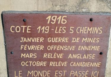
Départ au Centre d'Histoire du Mémorial 14-18 de Souchez. Ce circuit guide le randonneur sur les traces des soldats de la 1ère guerre mondiale tombés au combat pour la prise de la colline de Notre Dame de Lorette.
Localisation
Pays :
France
Région :
Hauts-de-France
Département/Province :
Pas-de-Calais
Commune :
Souchez
Localité :
Unknown
Départ:(Dec)
Départ:(UTM)
481534 ; 5583261 (31U) N.
Commentaires
Randonnées à proximité
![Randonnée Marche Liévin - 50 km Lievin en nocturne - Photo](https://media.geolcdn.com/t/375/260/ext.jpg?maxdim=2&url=https%3A%2F%2Fstatic1.geolcdn.com%2Fsiteimages%2Fupload%2Ffiles%2F1553511878bg_sport_marche.png)
![Marche Marche](https://static1.geolcdn.com/sitytour/trail-icons/101.png)
50 km Lievin en nocturne
Marche
Très difficile
(1)
Liévin,
Hauts-de-France,
Pas-de-Calais,
France
![](/images/other/stat-length.png)
52 km | 61 km-effort
9h 0min
![](https://static1.geolcdn.com/siteimages/upload/files/16400158638029165_repeat_loop_refresh_sync_direction_icon.png)
Oui
![Randonnée Marche Angres - randonnée pinchonvalles - Photo](https://media.geolcdn.com/t/375/260/b2891722-43d7-4acf-b8f9-14f5909069c3.jpg&format=jpg&maxdim=2)
![Marche Marche](https://static1.geolcdn.com/sitytour/trail-icons/101.png)
randonnée pinchonvalles
Marche
Très difficile
Angres,
Hauts-de-France,
Pas-de-Calais,
France
![](/images/other/stat-length.png)
27 km | 0 m-effort
3h 24min
![](https://static1.geolcdn.com/siteimages/upload/files/16400158638029165_repeat_loop_refresh_sync_direction_icon.png)
Non
![Randonnée Autre activité Liévin - boucle Liévin - Photo](https://media.geolcdn.com/t/375/260/ext.jpg?maxdim=2&url=https%3A%2F%2Fservices.sitytrail.com%2FGeolivesWS%2FDownloadMedia.ashx%3FTrailID%3D956017%26Media%3D20180429102202.jpg)
![Autre activité Autre activité](https://static1.geolcdn.com/sitytour/trail-icons/900.png)
boucle Liévin
Autre activité
Très facile
Liévin,
Hauts-de-France,
Pas-de-Calais,
France
![](/images/other/stat-length.png)
11 km | 12,3 km-effort
2h 2min
![](https://static1.geolcdn.com/siteimages/upload/files/16400158638029165_repeat_loop_refresh_sync_direction_icon.png)
Oui
![Randonnée Autre activité Liévin - boucle Liévin - Photo](https://media.geolcdn.com/t/375/260/ext.jpg?maxdim=2&url=https%3A%2F%2Fservices.sitytrail.com%2FGeolivesWS%2FDownloadMedia.ashx%3FTrailID%3D953687%26Media%3D20180429102202.jpg)
![Autre activité Autre activité](https://static1.geolcdn.com/sitytour/trail-icons/900.png)
boucle Liévin
Autre activité
Très facile
Liévin,
Hauts-de-France,
Pas-de-Calais,
France
![](/images/other/stat-length.png)
11 km | 12,3 km-effort
2h 2min
![](https://static1.geolcdn.com/siteimages/upload/files/16400158638029165_repeat_loop_refresh_sync_direction_icon.png)
Oui
![Randonnée Course à pied Aix-Noulette - aix noulette sity guide 25,3 km D530+ - Photo](https://media.geolcdn.com/t/375/260/ext.jpg?maxdim=2&url=https%3A%2F%2Fservices.sitytrail.com%2FGeolivesWS%2FDownloadMedia.ashx%3FTrailID%3D229340%26Media%3Dfix__20131027100347.jpg)
![Course à pied Course à pied](https://static1.geolcdn.com/sitytour/trail-icons/103.png)
aix noulette sity guide 25,3 km D530+
Course à pied
Moyen
Aix-Noulette,
Hauts-de-France,
Pas-de-Calais,
France
![](/images/other/stat-length.png)
23 km | 30 km-effort
2h 45min
![](https://static1.geolcdn.com/siteimages/upload/files/16400158638029165_repeat_loop_refresh_sync_direction_icon.png)
Oui
![Randonnée Marche Souchez - Souchez-Noulette-Lorette-Ablain - Photo](https://media.geolcdn.com/t/375/260/ext.jpg?maxdim=2&url=https%3A%2F%2Fservices.sitytrail.com%2FGeolivesWS%2FDownloadMedia.ashx%3FTrailID%3D173056%26Media%3D14580_6.jpg)
![Marche Marche](https://static1.geolcdn.com/sitytour/trail-icons/101.png)
Souchez-Noulette-Lorette-Ablain
Marche
Facile
Souchez,
Hauts-de-France,
Pas-de-Calais,
France
![](/images/other/stat-length.png)
6,7 km | 8,4 km-effort
1h 45min
![](https://static1.geolcdn.com/siteimages/upload/files/16400158638029165_repeat_loop_refresh_sync_direction_icon.png)
Oui
![Randonnée Marche Ablain-Saint-Nazaire - lorette août 23 - Photo](https://media.geolcdn.com/t/375/260/d5179cbf-eb3e-488a-9ec7-560d31757a4b.jpg&format=jpg&maxdim=2)
![Marche Marche](https://static1.geolcdn.com/sitytour/trail-icons/101.png)
lorette août 23
Marche
Difficile
Ablain-Saint-Nazaire,
Hauts-de-France,
Pas-de-Calais,
France
![](/images/other/stat-length.png)
11,8 km | 15,6 km-effort
2h 29min
![](https://static1.geolcdn.com/siteimages/upload/files/16400158638029165_repeat_loop_refresh_sync_direction_icon.png)
Non
![Randonnée Marche Ablain-Saint-Nazaire - autour d'Alain Saint nazaire - Photo](https://media.geolcdn.com/t/375/260/7e31f38f-bab6-47c8-ae7b-e7b39fa09888.jpg&format=jpg&maxdim=2)
![Marche Marche](https://static1.geolcdn.com/sitytour/trail-icons/101.png)
autour d'Alain Saint nazaire
Marche
Moyen
Ablain-Saint-Nazaire,
Hauts-de-France,
Pas-de-Calais,
France
![](/images/other/stat-length.png)
8,9 km | 11,1 km-effort
2h 4min
![](https://static1.geolcdn.com/siteimages/upload/files/16400158638029165_repeat_loop_refresh_sync_direction_icon.png)
Oui
![Randonnée Marche Souchez - Lorette et Carency CAF - Photo](https://media.geolcdn.com/t/375/260/ext.jpg?maxdim=2&url=https%3A%2F%2Fservices.sitytrail.com%2FGeolivesWS%2FDownloadMedia.ashx%3FTrailID%3D629786%26Media%3Dfix__20160911110430.jpg)
![Marche Marche](https://static1.geolcdn.com/sitytour/trail-icons/101.png)
Lorette et Carency CAF
Marche
Facile
Souchez,
Hauts-de-France,
Pas-de-Calais,
France
![](/images/other/stat-length.png)
21 km | 25 km-effort
5h 24min
![](https://static1.geolcdn.com/siteimages/upload/files/16400158638029165_repeat_loop_refresh_sync_direction_icon.png)
Oui