![](/images/other/stat-length.png)
![Randonnée Marche Saint-Sulpice-sur-Lèze - 14002122-Saint Sulpice sur Lèze](https://media.geolcdn.com/t/1900/400/ext.pjpeg?maxdim=2&url=https%3A%2F%2Fstatic1.geolcdn.com%2Fsiteimages%2Fupload%2Ffiles%2F1553511878bg_sport_marche.png)
14002122-Saint Sulpice sur Lèze "Labat"
pidjam
Utilisateur
![Longueur](/images/other/stat-length.png)
Longueur
7,9 km
![Altitude max](https://static1.geolcdn.com/siteimages/upload/files/1508320355ic_sort_altitude_max_24dp.png)
Altitude max
271 m
![Dénivelé positif](https://static1.geolcdn.com/siteimages/upload/files/1508320355ic_sort_den_pos_24dp.png)
Dénivelé positif
111 m
![Km-Effort](/images/other/stat-length.png)
Km-Effort
9,4 km
![Altitude min](https://static1.geolcdn.com/siteimages/upload/files/1508320355ic_sort_altitude_min_24dp.png)
Altitude min
193 m
![Dénivelé négatif](https://static1.geolcdn.com/siteimages/upload/files/1508320355ic_sort_den_neg_24dp.png)
Dénivelé négatif
110 m
![Boucle](https://static1.geolcdn.com/siteimages/upload/files/16400158638029165_repeat_loop_refresh_sync_direction_icon.png)
Boucle
Oui
Date de création :
2022-02-03 08:09:26.374
Dernière modification :
2022-02-03 08:10:43.773
![Marche](https://static1.geolcdn.com/sitytour/trail-icons/101.png)
2h07
Difficulté : Moyen
![Scannez ce code QR pour ouvrir la randonnée dans l'application SityTrail](https://capi.geolives.com/qq0zvz2zws4bq2lad0pu/sitytour/trails/3073985/qr.png?size=200)
Application GPS de randonnée GRATUITE
À propos
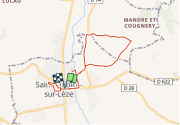
Randonnée Marche de 7,9 km à découvrir à Occitanie, Haute-Garonne, Saint-Sulpice-sur-Lèze. Cette randonnée est proposée par pidjam.
Description
Ce parcours emprunte les chemins de l'Office du tourisme du Volvestre, auxquels s'ajoute une petite boucle à ST Sulpice pour découvrir l'intérieur du village.
Localisation
Pays :
France
Région :
Occitanie
Département/Province :
Haute-Garonne
Commune :
Saint-Sulpice-sur-Lèze
Localité :
Unknown
Départ:(Dec)
Départ:(UTM)
364013 ; 4798647 (31T) N.
Commentaires
Randonnées à proximité
![Randonnée Marche Montgazin - montgazoin - Photo](https://media.geolcdn.com/t/375/260/ext.jpg?maxdim=2&url=https%3A%2F%2Fstatic1.geolcdn.com%2Fsiteimages%2Fupload%2Ffiles%2F1553511878bg_sport_marche.png)
![Marche Marche](https://static1.geolcdn.com/sitytour/trail-icons/101.png)
montgazoin
Marche
Moyen
Montgazin,
Occitanie,
Haute-Garonne,
France
![](/images/other/stat-length.png)
7,4 km | 0 m-effort
2h 12min
![](https://static1.geolcdn.com/siteimages/upload/files/16400158638029165_repeat_loop_refresh_sync_direction_icon.png)
Oui
![Randonnée Marche Saint-Sulpice-sur-Lèze - Saint-Sulpice-sur -Lèze pesquiès - Photo](https://media.geolcdn.com/t/375/260/ext.jpg?maxdim=2&url=https%3A%2F%2Fstatic1.geolcdn.com%2Fsiteimages%2Fupload%2Ffiles%2F1553511878bg_sport_marche.png)
![Marche Marche](https://static1.geolcdn.com/sitytour/trail-icons/101.png)
Saint-Sulpice-sur -Lèze pesquiès
Marche
Moyen
Saint-Sulpice-sur-Lèze,
Occitanie,
Haute-Garonne,
France
![](/images/other/stat-length.png)
9,5 km | 11,9 km-effort
2h 32min
![](https://static1.geolcdn.com/siteimages/upload/files/16400158638029165_repeat_loop_refresh_sync_direction_icon.png)
Oui
![Randonnée Marche Montaut - montaut fait - Photo](https://media.geolcdn.com/t/375/260/ext.jpg?maxdim=2&url=https%3A%2F%2Fstatic1.geolcdn.com%2Fsiteimages%2Fupload%2Ffiles%2F1553511878bg_sport_marche.png)
![Marche Marche](https://static1.geolcdn.com/sitytour/trail-icons/101.png)
montaut fait
Marche
Facile
Montaut,
Occitanie,
Haute-Garonne,
France
![](/images/other/stat-length.png)
10,2 km | 13,4 km-effort
2h 54min
![](https://static1.geolcdn.com/siteimages/upload/files/16400158638029165_repeat_loop_refresh_sync_direction_icon.png)
Oui
![Randonnée Marche Saint-Sulpice-sur-Lèze - moulin des Bures - Photo](https://media.geolcdn.com/t/375/260/ext.jpg?maxdim=2&url=https%3A%2F%2Fstatic1.geolcdn.com%2Fsiteimages%2Fupload%2Ffiles%2F1553511878bg_sport_marche.png)
![Marche Marche](https://static1.geolcdn.com/sitytour/trail-icons/101.png)
moulin des Bures
Marche
Facile
Saint-Sulpice-sur-Lèze,
Occitanie,
Haute-Garonne,
France
![](/images/other/stat-length.png)
3,5 km | 4,6 km-effort
1h 0min
![](https://static1.geolcdn.com/siteimages/upload/files/16400158638029165_repeat_loop_refresh_sync_direction_icon.png)
Oui
![Randonnée Marche Saint-Sulpice-sur-Lèze - moulin des Bures - Photo](https://media.geolcdn.com/t/375/260/ext.jpg?maxdim=2&url=https%3A%2F%2Fstatic1.geolcdn.com%2Fsiteimages%2Fupload%2Ffiles%2F1553511878bg_sport_marche.png)
![Marche Marche](https://static1.geolcdn.com/sitytour/trail-icons/101.png)
moulin des Bures
Marche
Facile
Saint-Sulpice-sur-Lèze,
Occitanie,
Haute-Garonne,
France
![](/images/other/stat-length.png)
3,5 km | 4,6 km-effort
Inconnu
![](https://static1.geolcdn.com/siteimages/upload/files/16400158638029165_repeat_loop_refresh_sync_direction_icon.png)
Oui
![Randonnée Marche Montaut - Alain noe - Photo](https://media.geolcdn.com/t/375/260/ext.jpg?maxdim=2&url=https%3A%2F%2Fstatic1.geolcdn.com%2Fsiteimages%2Fupload%2Ffiles%2F1553511878bg_sport_marche.png)
![Marche Marche](https://static1.geolcdn.com/sitytour/trail-icons/101.png)
Alain noe
Marche
Facile
Montaut,
Occitanie,
Haute-Garonne,
France
![](/images/other/stat-length.png)
4,1 km | 5,1 km-effort
1h 10min
![](https://static1.geolcdn.com/siteimages/upload/files/16400158638029165_repeat_loop_refresh_sync_direction_icon.png)
Non
![Randonnée Marche Noé - Jpm - Photo](https://media.geolcdn.com/t/375/260/ext.jpg?maxdim=2&url=https%3A%2F%2Fstatic1.geolcdn.com%2Fsiteimages%2Fupload%2Ffiles%2F1553511878bg_sport_marche.png)
![Marche Marche](https://static1.geolcdn.com/sitytour/trail-icons/101.png)
![Randonnée Marche Noé - Noé fait 2025 - Photo](https://media.geolcdn.com/t/375/260/ext.jpg?maxdim=2&url=https%3A%2F%2Fstatic1.geolcdn.com%2Fsiteimages%2Fupload%2Ffiles%2F1553511878bg_sport_marche.png)
![Marche Marche](https://static1.geolcdn.com/sitytour/trail-icons/101.png)
Noé fait 2025
Marche
Facile
Noé,
Occitanie,
Haute-Garonne,
France
![](/images/other/stat-length.png)
8,7 km | 11,8 km-effort
2h 21min
![](https://static1.geolcdn.com/siteimages/upload/files/16400158638029165_repeat_loop_refresh_sync_direction_icon.png)
Oui
![Randonnée Marche Montgazin - Montgazin fait 2024 mai - Photo](https://media.geolcdn.com/t/375/260/ext.jpg?maxdim=2&url=https%3A%2F%2Fstatic1.geolcdn.com%2Fsiteimages%2Fupload%2Ffiles%2F1553511878bg_sport_marche.png)
![Marche Marche](https://static1.geolcdn.com/sitytour/trail-icons/101.png)
Montgazin fait 2024 mai
Marche
Facile
Montgazin,
Occitanie,
Haute-Garonne,
France
![](/images/other/stat-length.png)
7,5 km | 9,6 km-effort
1h 53min
![](https://static1.geolcdn.com/siteimages/upload/files/16400158638029165_repeat_loop_refresh_sync_direction_icon.png)
Oui