Randonnée Cheval Mont Lozère et Goulet - T20140522 Jeu Randonnée Lozere - Mas d'Orcières (boucle) - Photo

T20140522 Jeu Randonnée Lozere - Mas d'Orcières (boucle)

 johann.holl
johann.holl

Utilisateur

© OpenStreetMap contributors
Longueur
Longueur
29 km
Altitude max
Altitude max
1286 m
Dénivelé positif
Dénivelé positif
935 m
Km-Effort
Km-Effort  
42 km
Altitude min
Altitude min
906 m
Dénivelé négatif
Dénivelé négatif
934 m
Boucle
Boucle
Oui
Date de création :
2014-12-10 00:00:00.0
Dernière modification :
2022-04-22 21:47:27.253

(0 Avis)

Cheval
Cheval
6h12
Difficulté : Inconnu

Scannez ce code QR pour ouvrir la randonnée dans l'application SityTrail

Application GPS de randonnée GRATUITE

Logo SityTrail SityTrail

IGN / Instituts géographiques

Télécharger SityTrail sur l'App Store Télécharger SityTrail sur Google Play

Logo SityTrail SityTrail World

Le monde est à vous

Télécharger SityTrail sur l'App Store Télécharger SityTrail sur Google Play Télécharger SityTrail sur Huawei AppGallery

À propos

Randonnée Cheval de 29 km à découvrir à Occitanie, Lozère, Mont Lozère et Goulet. Cette randonnée est proposée par johann.holl.

Profil altimétrique

Localisation

Pays :
France
Région :
Occitanie
Département/Province :
Lozère
Commune :
Mont Lozère et Goulet
Localité :
Unknown
Départ:(Dec)
Départ:(UTM)
556271 ; 4925368 (31T) N.

Randonnées à proximité

Randonnée V.T.T. Cubières - TOUR MONT LOZERE - Photo
V.T.T.
asclier0

V.T.T.

Très difficile
(1)
Cubières, Occitanie, Lozère, France
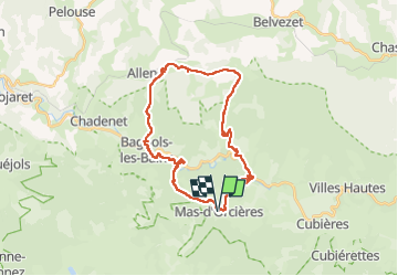
38 km | 47 km-effort
3h 14min
Oui
Randonnée Marche Mont Lozère et Goulet - Bleymar _ Le Pont Montvert - Photo
Marche
MoulinPierrick

Marche

Difficile
(1)
Mont Lozère et Goulet, Occitanie, Lozère, France
22 km | 32 km-effort
5h 19min
Non
Randonnée Marche Mont Lozère et Goulet - Chemin de Stevenson - Le Bleymard vers Le Pont de Montvert - Photo
Marche
tracegps

Marche

Difficile
(1)
Mont Lozère et Goulet, Occitanie, Lozère, France
18,9 km | 28 km-effort
4h 30min
Non
Randonnée Marche Mont Lozère et Goulet - 12-05-2023 E7 Bonnetés - Le Pont de Monvers  - Photo
Marche
GUIDE
Kargil

Marche

Difficile
Mont Lozère et Goulet, Occitanie, Lozère, France
25 km | 35 km-effort
7h 59min
Non
Randonnée Marche Mont Lozère et Goulet - Stevenson étape 8 - Photo
Marche
GUIDE
nadinebondoux

Marche

Difficile
Mont Lozère et Goulet, Occitanie, Lozère, France
20 km | 30 km-effort
5h 29min
Non
Randonnée Marche Mont Lozère et Goulet - Le Bleymard_La Crouzette par le chemin Stevenson_10,5Km - Photo
Marche
Pousscailleux

Marche

Difficile
(1)
Mont Lozère et Goulet, Occitanie, Lozère, France
10,6 km | 14,4 km-effort
3h 2min
Oui
Randonnée Autre activité Mont Lozère et Goulet - lundi - Photo
Autre activité
olivier78000

Autre activité

Moyen
(1)
Mont Lozère et Goulet, Occitanie, Lozère, France
10,3 km | 14,5 km-effort
3h 29min
Non
Randonnée Marche Mont Lozère et Goulet - Château de Tournel - Photo
Marche
nolsim

Marche

Moyen
Mont Lozère et Goulet, Occitanie, Lozère, France
14,1 km | 22 km-effort
7h 25min
Oui
Randonnée Marche Mont Lozère et Goulet - Etape 6 le Bleymard  / Pont Montvert - Photo
Marche
Nathalie. Mercier

Marche

Difficile
Mont Lozère et Goulet, Occitanie, Lozère, France
20 km | 29 km-effort
5h 31min
Non


Fermer
Mes abonnements