![](/images/other/stat-length.png)
![Randonnée Marche Doué-en-Anjou - La butte d’Argentay - Photo](https://media.geolcdn.com/t/1900/400/ext.pjpeg?maxdim=2&url=https%3A%2F%2Fstatic1.geolcdn.com%2Fsiteimages%2Fupload%2Ffiles%2F1553511878bg_sport_marche.png)
La butte d’Argentay
neoroll44
Utilisateur
![Longueur](/images/other/stat-length.png)
![Altitude max](https://static1.geolcdn.com/siteimages/upload/files/1508320355ic_sort_altitude_max_24dp.png)
![Dénivelé positif](https://static1.geolcdn.com/siteimages/upload/files/1508320355ic_sort_den_pos_24dp.png)
![Km-Effort](/images/other/stat-length.png)
![Altitude min](https://static1.geolcdn.com/siteimages/upload/files/1508320355ic_sort_altitude_min_24dp.png)
![Dénivelé négatif](https://static1.geolcdn.com/siteimages/upload/files/1508320355ic_sort_den_neg_24dp.png)
![Boucle](https://static1.geolcdn.com/siteimages/upload/files/16400158638029165_repeat_loop_refresh_sync_direction_icon.png)
![Marche](https://static1.geolcdn.com/sitytour/trail-icons/101.png)
2h00
Difficulté : Moyen
![Scannez ce code QR pour ouvrir la randonnée dans l'application SityTrail](https://capi.geolives.com/qq0zvz2zws4bq2lad0pu/sitytour/trails/3071210/qr.png?size=200)
Application GPS de randonnée GRATUITE
À propos
Randonnée Marche de 8,3 km à découvrir à Pays de la Loire, Maine-et-Loire, Doué-en-Anjou. Cette randonnée est proposée par neoroll44.
Description
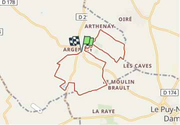
Départ : De Verchers-sur-Layon rejoindre Argentay à 3km du bourg et se garer à proximité de la chapelle.
Balisage Jaune.
(D/A) Du départ, prenez à gauche sur la Rue de la Chapelle jusqu'au carrefour.
(1) Continuez en face sur le chemin. Tournez à gauche et puis tout de suite à droite sur le sentier.
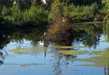
(2) Sur le prochain chemin, tournez à gauche, puis prenez le sentier à droite qui fait le tour du plan d'eau.
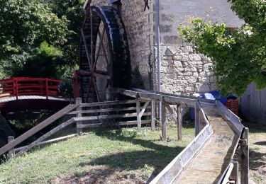
(3) Reprenez la route et tournez tout de suite à droite. Tournez de nouveau à droite sur le sentier puis ensuite à gauche. Passez le Moulin de Mézière, suivez le chemin jusqu'au carrefour et traversez pour continuer en face.
(4) Après le carrefour, prenez le premier chemin à gauche. Suivez-le ainsi jusqu'à la route, puis tournez à gauche et tout de suite à droite.
(5) Au bout du chemin, tournez à gauche. Suivez le chemin jusqu'à la route. Suivez celle-ci jusqu'au virage à l'entrée d'Argentay.
(6) Tournez à droite pour prendre un petit sentier. Suivez le sentier. Tournez à droite, à gauche puis de nouveau à droite. Suivez ce sentier, sans jamais bifurquer, jusqu'à la route et virez à droite.
(7) Prenez le premier sentier à gauche, puis tournez à gauche. Continuez toujours tout droit jusqu'à la route à Arthenay.
(8) Tournez à gauche et suivez la route jusqu'au carrefour. Partez à gauche et puis tout de suite à droite. Suivez le sentier puis tournez à droite pour rejoindre la route (Rue des Noyers).
(9) Sur la route, tournez à gauche et continuez toujours tout droit jusqu'à la chapelle (D/A).
Points d'intérêt
Localisation
Commentaires
Randonnées à proximité
![Randonnée Marche Vaudelnay - Montreuil Bellay- St Martin de Sanzay - Photo](https://media.geolcdn.com/t/375/260/5e8706aa-82ff-4811-80a6-4c098d7d3a98.jpg&format=jpg&maxdim=2)
![Marche Marche](https://static1.geolcdn.com/sitytour/trail-icons/101.png)
Marche
![](/images/other/stat-length.png)
![](https://static1.geolcdn.com/siteimages/upload/files/16400158638029165_repeat_loop_refresh_sync_direction_icon.png)
![Randonnée A pied Lys-Haut-Layon - Le sentier de la forêt - Photo](https://media.geolcdn.com/t/375/260/ext.jpg?maxdim=2&url=https%3A%2F%2Fstatic1.geolcdn.com%2Fsiteimages%2Fupload%2Ffiles%2F1545311037marcheuse_200dpi.jpg)
![A pied A pied](https://static1.geolcdn.com/sitytour/trail-icons/100.png)
A pied
![](/images/other/stat-length.png)
![](https://static1.geolcdn.com/siteimages/upload/files/16400158638029165_repeat_loop_refresh_sync_direction_icon.png)
![Randonnée Marche Vaudelnay - Vaudelnay - Photo](https://media.geolcdn.com/t/375/260/fb2de68a-d688-43bc-af37-4f32384a6791.jpg&format=jpg&maxdim=2)
![Marche Marche](https://static1.geolcdn.com/sitytour/trail-icons/101.png)
Marche
![](/images/other/stat-length.png)
![](https://static1.geolcdn.com/siteimages/upload/files/16400158638029165_repeat_loop_refresh_sync_direction_icon.png)
![Randonnée Vélo de route Doué-en-Anjou - 2023 Ascension - projet 2 - ouest - Photo](https://media.geolcdn.com/t/375/260/ext.jpg?maxdim=2&url=https%3A%2F%2Fstatic1.geolcdn.com%2Fsiteimages%2Fupload%2Ffiles%2F1524743154velo.jpg)
![Vélo de route Vélo de route](https://static1.geolcdn.com/sitytour/trail-icons/201.png)
Vélo de route
![](/images/other/stat-length.png)
![](https://static1.geolcdn.com/siteimages/upload/files/16400158638029165_repeat_loop_refresh_sync_direction_icon.png)
![Randonnée Vélo de route Doué-en-Anjou - 2023 Ascension - projet 1 - nord - Photo](https://media.geolcdn.com/t/375/260/ext.jpg?maxdim=2&url=https%3A%2F%2Fstatic1.geolcdn.com%2Fsiteimages%2Fupload%2Ffiles%2F1524743154velo.jpg)
![Vélo de route Vélo de route](https://static1.geolcdn.com/sitytour/trail-icons/201.png)
Vélo de route
![](/images/other/stat-length.png)
![](https://static1.geolcdn.com/siteimages/upload/files/16400158638029165_repeat_loop_refresh_sync_direction_icon.png)
![Randonnée Vélo de route Doué-en-Anjou - 2023 Ascension - projet 3 - sud est - Photo](https://media.geolcdn.com/t/375/260/ext.jpg?maxdim=2&url=https%3A%2F%2Fstatic1.geolcdn.com%2Fsiteimages%2Fupload%2Ffiles%2F1524743154velo.jpg)
![Vélo de route Vélo de route](https://static1.geolcdn.com/sitytour/trail-icons/201.png)
Vélo de route
![](/images/other/stat-length.png)
![](https://static1.geolcdn.com/siteimages/upload/files/16400158638029165_repeat_loop_refresh_sync_direction_icon.png)
![Randonnée Marche Vaudelnay - De bois en vignes et lavoirs autour du Vaudelnay - Photo](https://media.geolcdn.com/t/375/260/ext.jpg?maxdim=2&url=https%3A%2F%2Fstatic1.geolcdn.com%2Fsiteimages%2Fupload%2Ffiles%2F1553511878bg_sport_marche.png)
![Marche Marche](https://static1.geolcdn.com/sitytour/trail-icons/101.png)
Marche
![](/images/other/stat-length.png)
![](https://static1.geolcdn.com/siteimages/upload/files/16400158638029165_repeat_loop_refresh_sync_direction_icon.png)
![Randonnée V.T.T. Le Puy-Notre-Dame - le puy-zoo de doué - Photo](https://media.geolcdn.com/t/375/260/ext.jpg?maxdim=2&url=https%3A%2F%2Fstatic1.geolcdn.com%2Fsiteimages%2Fupload%2Ffiles%2F1524743154velo.jpg)
![V.T.T. V.T.T.](https://static1.geolcdn.com/sitytour/trail-icons/202.png)
V.T.T.
![](/images/other/stat-length.png)
![](https://static1.geolcdn.com/siteimages/upload/files/16400158638029165_repeat_loop_refresh_sync_direction_icon.png)
![Randonnée V.T.T. Le Puy-Notre-Dame - le puy-cisay la madeleine - Photo](https://media.geolcdn.com/t/375/260/ext.jpg?maxdim=2&url=https%3A%2F%2Fstatic1.geolcdn.com%2Fsiteimages%2Fupload%2Ffiles%2F1524743154velo.jpg)
![V.T.T. V.T.T.](https://static1.geolcdn.com/sitytour/trail-icons/202.png)
V.T.T.
![](/images/other/stat-length.png)
![](https://static1.geolcdn.com/siteimages/upload/files/16400158638029165_repeat_loop_refresh_sync_direction_icon.png)