![](/images/other/stat-length.png)
![Randonnée Marche Charleroi - MONT/S/M - vers l'Eau d'Heure et réserve Brun Chêne - Photo](https://media.geolcdn.com/t/1900/400/87953614-98ba-4c29-937a-35e3d553b61a.jpg&format=pjpeg&maxdim=2)
MONT/S/M - vers l'Eau d'Heure et réserve Brun Chêne
ELISECRO
Utilisateur
![Longueur](/images/other/stat-length.png)
Longueur
6,9 km
![Altitude max](https://static1.geolcdn.com/siteimages/upload/files/1508320355ic_sort_altitude_max_24dp.png)
Altitude max
153 m
![Dénivelé positif](https://static1.geolcdn.com/siteimages/upload/files/1508320355ic_sort_den_pos_24dp.png)
Dénivelé positif
83 m
![Km-Effort](/images/other/stat-length.png)
Km-Effort
8 km
![Altitude min](https://static1.geolcdn.com/siteimages/upload/files/1508320355ic_sort_altitude_min_24dp.png)
Altitude min
102 m
![Dénivelé négatif](https://static1.geolcdn.com/siteimages/upload/files/1508320355ic_sort_den_neg_24dp.png)
Dénivelé négatif
83 m
![Boucle](https://static1.geolcdn.com/siteimages/upload/files/16400158638029165_repeat_loop_refresh_sync_direction_icon.png)
Boucle
Oui
Date de création :
2022-01-26 08:56:20.638
Dernière modification :
2022-01-27 14:33:17.102
![Marche](https://static1.geolcdn.com/sitytour/trail-icons/101.png)
2h09
Difficulté : Moyen
![Scannez ce code QR pour ouvrir la randonnée dans l'application SityTrail](https://capi.geolives.com/qq0zvz2zws4bq2lad0pu/sitytour/trails/3064857/qr.png?size=200)
Application GPS de randonnée GRATUITE
À propos
Randonnée Marche de 6,9 km à découvrir à Wallonie, Hainaut, Charleroi. Cette randonnée est proposée par ELISECRO.
Description
petites routes secondaires - vers le "petit bois" de Mont Sur Marchienne (rue du Mayeuri) - vers le Moria et la statue de Darville - le sentier de l'Eau d'Heure et la réserve natagora du Brun Chêne
Localisation
Pays :
Belgique
Région :
Wallonie
Département/Province :
Hainaut
Commune :
Charleroi
Localité :
Unknown
Départ:(Dec)
Départ:(UTM)
599772 ; 5582695 (31U) N.
Commentaires
Randonnées à proximité
![Randonnée Marche Gerpinnes - La promenade des Lacs de Loverval - Photo](https://media.geolcdn.com/t/375/260/ext.jpg?maxdim=2&url=https%3A%2F%2Fstatic1.geolcdn.com%2Fsiteimages%2Fupload%2Ffiles%2F1553511878bg_sport_marche.png)
![Marche Marche](https://static1.geolcdn.com/sitytour/trail-icons/101.png)
La promenade des Lacs de Loverval
Marche
Facile
(7)
Gerpinnes,
Wallonie,
Hainaut,
Belgique
![](/images/other/stat-length.png)
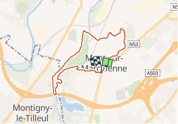
8,5 km | 10,6 km-effort
2h 10min
![](https://static1.geolcdn.com/siteimages/upload/files/16400158638029165_repeat_loop_refresh_sync_direction_icon.png)
Oui
![Randonnée Marche Montigny-le-Tilleul - A la découverte des sentes et venelles de Montigny-le-Tilleul - Photo](https://media.geolcdn.com/t/375/260/ext.jpg?maxdim=2&url=https%3A%2F%2Fstatic1.geolcdn.com%2Fsiteimages%2Fupload%2Ffiles%2F1553511878bg_sport_marche.png)
![Marche Marche](https://static1.geolcdn.com/sitytour/trail-icons/101.png)
A la découverte des sentes et venelles de Montigny-le-Tilleul
Marche
Facile
(6)
Montigny-le-Tilleul,
Wallonie,
Hainaut,
Belgique
![](/images/other/stat-length.png)
7,8 km | 9,9 km-effort
2h 0min
![](https://static1.geolcdn.com/siteimages/upload/files/16400158638029165_repeat_loop_refresh_sync_direction_icon.png)
Oui
![Randonnée Marche Fontaine-l'Évêque - de l'Abbaye d'Aulne au hameau de Hourpes - Thuin - Photo](https://media.geolcdn.com/t/375/260/a34a09f7-2ebf-4334-b3ab-6307c79b316f.jpeg&format=jpg&maxdim=2)
![Marche Marche](https://static1.geolcdn.com/sitytour/trail-icons/101.png)
de l'Abbaye d'Aulne au hameau de Hourpes - Thuin
Marche
Très facile
(2)
Fontaine-l'Évêque,
Wallonie,
Hainaut,
Belgique
![](/images/other/stat-length.png)
8,7 km | 10,9 km-effort
3h 16min
![](https://static1.geolcdn.com/siteimages/upload/files/16400158638029165_repeat_loop_refresh_sync_direction_icon.png)
Oui
![Randonnée Marche Charleroi - Balade de Marchienne-au-Pont à Charleroi - Photo](https://media.geolcdn.com/t/375/260/ext.jpg?maxdim=2&url=https%3A%2F%2Fservices.sitytrail.com%2FGeolivesWS%2FDownloadMedia.ashx%3FTrailID%3D949334%26Media%3D4dded785-5147-47ae-8985-edbbb0a17b68.jpg)
![Marche Marche](https://static1.geolcdn.com/sitytour/trail-icons/101.png)
Balade de Marchienne-au-Pont à Charleroi
Marche
Moyen
(3)
Charleroi,
Wallonie,
Hainaut,
Belgique
![](/images/other/stat-length.png)
12,8 km | 15,8 km-effort
3h 23min
![](https://static1.geolcdn.com/siteimages/upload/files/16400158638029165_repeat_loop_refresh_sync_direction_icon.png)
Oui
![Randonnée Marche Montigny-le-Tilleul - Balade en Val de Sambre - De Landelies à l'Abbaye d'Aulne - Photo](https://media.geolcdn.com/t/375/260/ext.jpg?maxdim=2&url=https%3A%2F%2Fservices.sitytrail.com%2FGeolivesWS%2FDownloadMedia.ashx%3FTrailID%3D498562%26Media%3D0c817a37-45f6-4c22-ab94-a572de965186.JPG)
![Marche Marche](https://static1.geolcdn.com/sitytour/trail-icons/101.png)
Balade en Val de Sambre - De Landelies à l'Abbaye d'Aulne
Marche
Très facile
(1)
Montigny-le-Tilleul,
Wallonie,
Hainaut,
Belgique
![](/images/other/stat-length.png)
6,6 km | 8 km-effort
1h 49min
![](https://static1.geolcdn.com/siteimages/upload/files/16400158638029165_repeat_loop_refresh_sync_direction_icon.png)
Oui
![Marche Marche](https://static1.geolcdn.com/sitytour/trail-icons/101.png)
BE-Montigny-le-Tilleul - Landelies - Aulne - 2
Marche
Très facile
(1)
Montigny-le-Tilleul,
Wallonie,
Hainaut,
Belgique
![](/images/other/stat-length.png)
7,1 km | 9,6 km-effort
2h 4min
![](https://static1.geolcdn.com/siteimages/upload/files/16400158638029165_repeat_loop_refresh_sync_direction_icon.png)
Oui
![Randonnée Marche Charleroi - Balade à Monceau-sur-Sambre - Photo](https://media.geolcdn.com/t/375/260/ext.jpg?maxdim=2&url=https%3A%2F%2Fservices.sitytrail.com%2FGeolivesWS%2FDownloadMedia.ashx%3FTrailID%3D333133%26Media%3D8178f634-f079-4d05-944b-2b2fb0f50083.JPG)
![Marche Marche](https://static1.geolcdn.com/sitytour/trail-icons/101.png)
Balade à Monceau-sur-Sambre
Marche
Très facile
(4)
Charleroi,
Wallonie,
Hainaut,
Belgique
![](/images/other/stat-length.png)
8,9 km | 10,7 km-effort
2h 21min
![](https://static1.geolcdn.com/siteimages/upload/files/16400158638029165_repeat_loop_refresh_sync_direction_icon.png)
Oui
![Randonnée Marche Charleroi - RB-Ha-06 - Bois du Cazier - Photo](https://media.geolcdn.com/t/375/260/ext.jpg?maxdim=2&url=https%3A%2F%2Fservices.sitytrail.com%2FGeolivesWS%2FDownloadMedia.ashx%3FTrailID%3D179599%26Media%3D2837e250-a032-4aff-9766-ede65c270e46.jpg)
![Marche Marche](https://static1.geolcdn.com/sitytour/trail-icons/101.png)
RB-Ha-06 - Bois du Cazier
Marche
Très difficile
(4)
Charleroi,
Wallonie,
Hainaut,
Belgique
![](/images/other/stat-length.png)
21 km | 26 km-effort
5h 58min
![](https://static1.geolcdn.com/siteimages/upload/files/16400158638029165_repeat_loop_refresh_sync_direction_icon.png)
Oui
![Randonnée Marche Charleroi - Terrils 1. dép rue chemin de fer,39.Marchienne - Photo](https://media.geolcdn.com/t/375/260/99108394-b48a-4f18-91eb-bf5bf6747a6b.jpg&format=jpg&maxdim=2)
![Marche Marche](https://static1.geolcdn.com/sitytour/trail-icons/101.png)
Terrils 1. dép rue chemin de fer,39.Marchienne
Marche
Difficile
(1)
Charleroi,
Wallonie,
Hainaut,
Belgique
![](/images/other/stat-length.png)
5,1 km | 6,4 km-effort
1h 43min
![](https://static1.geolcdn.com/siteimages/upload/files/16400158638029165_repeat_loop_refresh_sync_direction_icon.png)
Oui