![](/images/other/stat-length.png)
![Randonnée A pied Mennecy - JC 30 Les Etangs de Mennecy, Vert le Petit, Parc de Villeroy - Photo](https://media.geolcdn.com/t/1900/400/ext.pjpeg?maxdim=2&url=https%3A%2F%2Fstatic1.geolcdn.com%2Fsiteimages%2Fupload%2Ffiles%2F1545311037marcheuse_200dpi.jpg)
JC 30 Les Etangs de Mennecy, Vert le Petit, Parc de Villeroy
Les 1000 pattes
Club randonnées SERVON
![Longueur](/images/other/stat-length.png)
Longueur
18,5 km
![Altitude max](https://static1.geolcdn.com/siteimages/upload/files/1508320355ic_sort_altitude_max_24dp.png)
Altitude max
89 m
![Dénivelé positif](https://static1.geolcdn.com/siteimages/upload/files/1508320355ic_sort_den_pos_24dp.png)
Dénivelé positif
190 m
![Km-Effort](/images/other/stat-length.png)
Km-Effort
21 km
![Altitude min](https://static1.geolcdn.com/siteimages/upload/files/1508320355ic_sort_altitude_min_24dp.png)
Altitude min
43 m
![Dénivelé négatif](https://static1.geolcdn.com/siteimages/upload/files/1508320355ic_sort_den_neg_24dp.png)
Dénivelé négatif
187 m
![Boucle](https://static1.geolcdn.com/siteimages/upload/files/16400158638029165_repeat_loop_refresh_sync_direction_icon.png)
Boucle
Oui
Date de création :
2022-01-23 18:28:25.331
Dernière modification :
2022-06-01 15:10:41.208
![A pied](https://static1.geolcdn.com/sitytour/trail-icons/100.png)
4h03
Difficulté : Difficile
![Scannez ce code QR pour ouvrir la randonnée dans l'application SityTrail](https://capi.geolives.com/qq0zvz2zws4bq2lad0pu/sitytour/trails/3062089/qr.png?size=200)
Application GPS de randonnée GRATUITE
À propos
Randonnée A pied de 18,5 km à découvrir à Île-de-France, Essonne, Mennecy. Cette randonnée est proposée par Les 1000 pattes.
Description
Parking du Parc de Villeroy à Mennecy
Trajet Servon-->Parking (32km: 40mn)
Localisation
Pays :
France
Région :
Île-de-France
Département/Province :
Essonne
Commune :
Mennecy
Localité :
Unknown
Départ:(Dec)
Départ:(UTM)
457488 ; 5379369 (31U) N.
Commentaires
Randonnées à proximité
![Randonnée Marche Écharcon - Autour de Vert le Petit - Photo](https://media.geolcdn.com/t/375/260/ext.jpg?maxdim=2&url=https%3A%2F%2Fservices.sitytrail.com%2FGeolivesWS%2FDownloadMedia.ashx%3FTrailID%3D102739%26Media%3D3871_4.jpg)
![Marche Marche](https://static1.geolcdn.com/sitytour/trail-icons/101.png)
Autour de Vert le Petit
Marche
Moyen
(1)
Écharcon,
Île-de-France,
Essonne,
France
![](/images/other/stat-length.png)
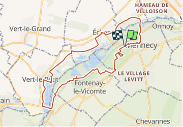
16 km | 17,9 km-effort
4h 0min
![](https://static1.geolcdn.com/siteimages/upload/files/16400158638029165_repeat_loop_refresh_sync_direction_icon.png)
Oui
![Randonnée A pied Mennecy - Boucle 20 km autour de Mennecy - Photo](https://media.geolcdn.com/t/375/260/a0d84bba-b7da-4081-b724-5ae5c2d178d5.jpg&format=jpg&maxdim=2)
![A pied A pied](https://static1.geolcdn.com/sitytour/trail-icons/100.png)
Boucle 20 km autour de Mennecy
A pied
Moyen
Mennecy,
Île-de-France,
Essonne,
France
![](/images/other/stat-length.png)
20 km | 23 km-effort
5h 15min
![](https://static1.geolcdn.com/siteimages/upload/files/16400158638029165_repeat_loop_refresh_sync_direction_icon.png)
Oui
![Randonnée Marche Ballancourt-sur-Essonne - Rando Ballancourt 15 km BM - Photo](https://media.geolcdn.com/t/375/260/8977c33c-1145-4a4f-97a7-a064e00deb0b.jpg&format=jpg&maxdim=2)
![Marche Marche](https://static1.geolcdn.com/sitytour/trail-icons/101.png)
Rando Ballancourt 15 km BM
Marche
Difficile
(1)
Ballancourt-sur-Essonne,
Île-de-France,
Essonne,
France
![](/images/other/stat-length.png)
14,8 km | 16,9 km-effort
3h 50min
![](https://static1.geolcdn.com/siteimages/upload/files/16400158638029165_repeat_loop_refresh_sync_direction_icon.png)
Oui
![Randonnée Marche Mennecy - Boucle 23 km au départ de Mennecy - Photo](https://media.geolcdn.com/t/375/260/d9409c0b-4ad5-436d-94de-44694c25ec6a.jpg&format=jpg&maxdim=2)
![Marche Marche](https://static1.geolcdn.com/sitytour/trail-icons/101.png)
Boucle 23 km au départ de Mennecy
Marche
Très facile
Mennecy,
Île-de-France,
Essonne,
France
![](/images/other/stat-length.png)
23 km | 26 km-effort
4h 52min
![](https://static1.geolcdn.com/siteimages/upload/files/16400158638029165_repeat_loop_refresh_sync_direction_icon.png)
Oui
![Randonnée Marche Ballancourt-sur-Essonne - Boucle autour de Ballancourt - Photo](https://media.geolcdn.com/t/375/260/726c3226-57e6-4792-b7bd-15745463bf1c.jpg&format=jpg&maxdim=2)
![Marche Marche](https://static1.geolcdn.com/sitytour/trail-icons/101.png)
Boucle autour de Ballancourt
Marche
Moyen
Ballancourt-sur-Essonne,
Île-de-France,
Essonne,
France
![](/images/other/stat-length.png)
21 km | 25 km-effort
4h 47min
![](https://static1.geolcdn.com/siteimages/upload/files/16400158638029165_repeat_loop_refresh_sync_direction_icon.png)
Oui
![Randonnée A pied Mennecy - Boucle autour de Mennecy - Photo](https://media.geolcdn.com/t/375/260/8b9e4ef7-6f9c-44d6-bf15-96d045d2bf54.jpg&format=jpg&maxdim=2)
![A pied A pied](https://static1.geolcdn.com/sitytour/trail-icons/100.png)
Boucle autour de Mennecy
A pied
Moyen
Mennecy,
Île-de-France,
Essonne,
France
![](/images/other/stat-length.png)
27 km | 30 km-effort
6h 48min
![](https://static1.geolcdn.com/siteimages/upload/files/16400158638029165_repeat_loop_refresh_sync_direction_icon.png)
Oui
![Randonnée A pied Mennecy - Boucle autour des étangs à partir de Mennecy - Photo](https://media.geolcdn.com/t/375/260/acd79014-5cb8-4e86-a933-bcce20350a9e.jpg&format=jpg&maxdim=2)
![A pied A pied](https://static1.geolcdn.com/sitytour/trail-icons/100.png)
Boucle autour des étangs à partir de Mennecy
A pied
Très facile
Mennecy,
Île-de-France,
Essonne,
France
![](/images/other/stat-length.png)
18,6 km | 21 km-effort
4h 44min
![](https://static1.geolcdn.com/siteimages/upload/files/16400158638029165_repeat_loop_refresh_sync_direction_icon.png)
Oui
![Randonnée Marche Saintry-sur-Seine - Boucle 30 km Saintry - Seine Port - Morsang - Photo](https://media.geolcdn.com/t/375/260/147882bb-b6f1-4169-80d4-53a2e8169cea.jpg&format=jpg&maxdim=2)
![Marche Marche](https://static1.geolcdn.com/sitytour/trail-icons/101.png)
Boucle 30 km Saintry - Seine Port - Morsang
Marche
Très facile
Saintry-sur-Seine,
Île-de-France,
Essonne,
France
![](/images/other/stat-length.png)
29 km | 34 km-effort
6h 15min
![](https://static1.geolcdn.com/siteimages/upload/files/16400158638029165_repeat_loop_refresh_sync_direction_icon.png)
Oui
![Randonnée Marche Ballancourt-sur-Essonne - Boucle Ballancourt 2 - Photo](https://media.geolcdn.com/t/375/260/128663b7-ad88-4864-9368-2c4190eb82be.jpg&format=jpg&maxdim=2)
![Marche Marche](https://static1.geolcdn.com/sitytour/trail-icons/101.png)
Boucle Ballancourt 2
Marche
Très facile
Ballancourt-sur-Essonne,
Île-de-France,
Essonne,
France
![](/images/other/stat-length.png)
21 km | 26 km-effort
7h 4min
![](https://static1.geolcdn.com/siteimages/upload/files/16400158638029165_repeat_loop_refresh_sync_direction_icon.png)
Oui