![](/images/other/stat-length.png)
![Randonnée Marche Loches - Loches Château de Sansac - Photo](https://media.geolcdn.com/t/1900/400/ext.pjpeg?maxdim=2&url=https%3A%2F%2Fstatic1.geolcdn.com%2Fsiteimages%2Fupload%2Ffiles%2F1553511878bg_sport_marche.png)
Loches Château de Sansac
jfcousty
Utilisateur
![Longueur](/images/other/stat-length.png)
Longueur
5,2 km
![Altitude max](https://static1.geolcdn.com/siteimages/upload/files/1508320355ic_sort_altitude_max_24dp.png)
Altitude max
91 m
![Dénivelé positif](https://static1.geolcdn.com/siteimages/upload/files/1508320355ic_sort_den_pos_24dp.png)
Dénivelé positif
45 m
![Km-Effort](/images/other/stat-length.png)
Km-Effort
5,8 km
![Altitude min](https://static1.geolcdn.com/siteimages/upload/files/1508320355ic_sort_altitude_min_24dp.png)
Altitude min
68 m
![Dénivelé négatif](https://static1.geolcdn.com/siteimages/upload/files/1508320355ic_sort_den_neg_24dp.png)
Dénivelé négatif
45 m
![Boucle](https://static1.geolcdn.com/siteimages/upload/files/16400158638029165_repeat_loop_refresh_sync_direction_icon.png)
Boucle
Oui
Date de création :
2022-01-22 12:01:28.951
Dernière modification :
2022-01-22 12:04:51.491
![Marche](https://static1.geolcdn.com/sitytour/trail-icons/101.png)
1h18
Difficulté : Facile
![Scannez ce code QR pour ouvrir la randonnée dans l'application SityTrail](https://capi.geolives.com/qq0zvz2zws4bq2lad0pu/sitytour/trails/3060093/qr.png?size=200)
Application GPS de randonnée GRATUITE
À propos
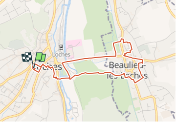
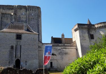
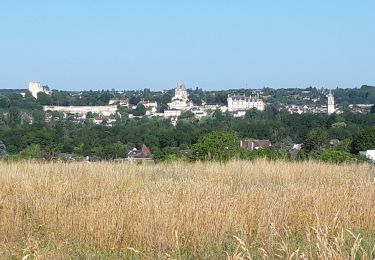
Randonnée Marche de 5,2 km à découvrir à Centre-Val de Loire, Indre-et-Loire, Loches. Cette randonnée est proposée par jfcousty.
Description
Départ parking place de Mazerolles
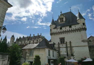
A voir restaurant "Arbore et sens" proche du départ au 22 rue Balzac à Loches
Localisation
Pays :
France
Région :
Centre-Val de Loire
Département/Province :
Indre-et-Loire
Commune :
Loches
Localité :
Unknown
Départ:(Dec)
Départ:(UTM)
347992 ; 5221333 (31T) N.
Commentaires
Randonnées à proximité
![Randonnée Marche Chambourg-sur-Indre - Chambourg-sur-Indre - l'Isle Auger Loches GR46 - 26.7km 325m 5h40 (30mn) - 2021 07 24 - Photo](https://media.geolcdn.com/t/375/260/4a4a0e65-7447-4912-8bb8-2b66ee7b1005.jpg&format=jpg&maxdim=2)
![Marche Marche](https://static1.geolcdn.com/sitytour/trail-icons/101.png)
Chambourg-sur-Indre - l'Isle Auger Loches GR46 - 26.7km 325m 5h40 (30mn) - 20...
Marche
Facile
Chambourg-sur-Indre,
Centre-Val de Loire,
Indre-et-Loire,
France
![](/images/other/stat-length.png)
27 km | 31 km-effort
5h 40min
![](https://static1.geolcdn.com/siteimages/upload/files/16400158638029165_repeat_loop_refresh_sync_direction_icon.png)
Oui
![Randonnée Marche Loches - Loches inondations - Photo](https://media.geolcdn.com/t/375/260/144ecdba-b2fd-487b-a529-ef2c3b74b16f.jpg&format=jpg&maxdim=2)
![Marche Marche](https://static1.geolcdn.com/sitytour/trail-icons/101.png)
Loches inondations
Marche
Très facile
Loches,
Centre-Val de Loire,
Indre-et-Loire,
France
![](/images/other/stat-length.png)
9,7 km | 11,2 km-effort
2h 51min
![](https://static1.geolcdn.com/siteimages/upload/files/16400158638029165_repeat_loop_refresh_sync_direction_icon.png)
Oui
![Randonnée Vélo de route Beaulieu-lès-Loches - 3eme étape Beaulieu-Chenôceaux - Photo](https://media.geolcdn.com/t/375/260/ext.jpg?maxdim=2&url=https%3A%2F%2Fstatic1.geolcdn.com%2Fsiteimages%2Fupload%2Ffiles%2F1524743154velo.jpg)
![Vélo de route Vélo de route](https://static1.geolcdn.com/sitytour/trail-icons/201.png)
3eme étape Beaulieu-Chenôceaux
Vélo de route
Très facile
Beaulieu-lès-Loches,
Centre-Val de Loire,
Indre-et-Loire,
France
![](/images/other/stat-length.png)
33 km | 37 km-effort
4h 50min
![](https://static1.geolcdn.com/siteimages/upload/files/16400158638029165_repeat_loop_refresh_sync_direction_icon.png)
Non
![Randonnée A pied Loches - Loches ville - Photo](https://media.geolcdn.com/t/375/260/ext.jpg?maxdim=2&url=https%3A%2F%2Fstatic1.geolcdn.com%2Fsiteimages%2Fupload%2Ffiles%2F1545311037marcheuse_200dpi.jpg)
![A pied A pied](https://static1.geolcdn.com/sitytour/trail-icons/100.png)
Loches ville
A pied
Facile
Loches,
Centre-Val de Loire,
Indre-et-Loire,
France
![](/images/other/stat-length.png)
4,8 km | 5,6 km-effort
1h 16min
![](https://static1.geolcdn.com/siteimages/upload/files/16400158638029165_repeat_loop_refresh_sync_direction_icon.png)
Non
![Randonnée Marche Loches - Rumba à loches épisode 3 - Photo](https://media.geolcdn.com/t/375/260/87415908-2596-4c2f-bd8a-3167adfe1a6c.jpg&format=jpg&maxdim=2)
![Marche Marche](https://static1.geolcdn.com/sitytour/trail-icons/101.png)
Rumba à loches épisode 3
Marche
Facile
Loches,
Centre-Val de Loire,
Indre-et-Loire,
France
![](/images/other/stat-length.png)
6,9 km | 7,4 km-effort
2h 15min
![](https://static1.geolcdn.com/siteimages/upload/files/16400158638029165_repeat_loop_refresh_sync_direction_icon.png)
Oui
![Randonnée Marche Loches - Loches - Photo](https://media.geolcdn.com/t/375/260/92ef212d-97f8-4acb-8490-748d20441a84.jpg&format=jpg&maxdim=2)
![Marche Marche](https://static1.geolcdn.com/sitytour/trail-icons/101.png)
Loches
Marche
Difficile
Loches,
Centre-Val de Loire,
Indre-et-Loire,
France
![](/images/other/stat-length.png)
10,4 km | 12,4 km-effort
2h 24min
![](https://static1.geolcdn.com/siteimages/upload/files/16400158638029165_repeat_loop_refresh_sync_direction_icon.png)
Oui
![Randonnée Marche Loches - Beaulieu lès Loches - Photo](https://media.geolcdn.com/t/375/260/ba2ee674-c503-4174-b199-696bb47ce4b5.jpg&format=jpg&maxdim=2)
![Marche Marche](https://static1.geolcdn.com/sitytour/trail-icons/101.png)
Beaulieu lès Loches
Marche
Difficile
Loches,
Centre-Val de Loire,
Indre-et-Loire,
France
![](/images/other/stat-length.png)
14,6 km | 16,5 km-effort
2h 34min
![](https://static1.geolcdn.com/siteimages/upload/files/16400158638029165_repeat_loop_refresh_sync_direction_icon.png)
Oui
![Randonnée Marche Loches - Boucle entre Loches et Beaulieu. - Photo](https://media.geolcdn.com/t/375/260/ext.jpg?maxdim=2&url=https%3A%2F%2Fstatic1.geolcdn.com%2Fsiteimages%2Fupload%2Ffiles%2F1553511878bg_sport_marche.png)
![Marche Marche](https://static1.geolcdn.com/sitytour/trail-icons/101.png)
Boucle entre Loches et Beaulieu.
Marche
Facile
Loches,
Centre-Val de Loire,
Indre-et-Loire,
France
![](/images/other/stat-length.png)
3,8 km | 4,1 km-effort
58min
![](https://static1.geolcdn.com/siteimages/upload/files/16400158638029165_repeat_loop_refresh_sync_direction_icon.png)
Oui
![Randonnée Course à pied Loches - Pslo7juin16 - Photo](https://media.geolcdn.com/t/375/260/ext.jpg?maxdim=2&url=https%3A%2F%2Fstatic1.geolcdn.com%2Fsiteimages%2Fupload%2Ffiles%2F1524743154running.jpg)
![Course à pied Course à pied](https://static1.geolcdn.com/sitytour/trail-icons/103.png)
Pslo7juin16
Course à pied
Moyen
Loches,
Centre-Val de Loire,
Indre-et-Loire,
France
![](/images/other/stat-length.png)
6 km | 6,8 km-effort
37min
![](https://static1.geolcdn.com/siteimages/upload/files/16400158638029165_repeat_loop_refresh_sync_direction_icon.png)
Oui