![](/images/other/stat-length.png)
![Randonnée Marche Latouille-Lentillac - Circuit des trois églises, Latouille lentillac - Photo](https://media.geolcdn.com/t/1900/400/ext.pjpeg?maxdim=2&url=https%3A%2F%2Fstatic1.geolcdn.com%2Fsiteimages%2Fupload%2Ffiles%2F1553511878bg_sport_marche.png)
Circuit des trois églises, Latouille lentillac
houbart
Utilisateur
![Longueur](/images/other/stat-length.png)
Longueur
13,5 km
![Altitude max](https://static1.geolcdn.com/siteimages/upload/files/1508320355ic_sort_altitude_max_24dp.png)
Altitude max
568 m
![Dénivelé positif](https://static1.geolcdn.com/siteimages/upload/files/1508320355ic_sort_den_pos_24dp.png)
Dénivelé positif
488 m
![Km-Effort](/images/other/stat-length.png)
Km-Effort
20 km
![Altitude min](https://static1.geolcdn.com/siteimages/upload/files/1508320355ic_sort_altitude_min_24dp.png)
Altitude min
220 m
![Dénivelé négatif](https://static1.geolcdn.com/siteimages/upload/files/1508320355ic_sort_den_neg_24dp.png)
Dénivelé négatif
496 m
![Boucle](https://static1.geolcdn.com/siteimages/upload/files/16400158638029165_repeat_loop_refresh_sync_direction_icon.png)
Boucle
Oui
Date de création :
2022-01-16 18:17:25.738
Dernière modification :
2022-01-16 18:19:36.556
![Marche](https://static1.geolcdn.com/sitytour/trail-icons/101.png)
4h32
Difficulté : Très difficile
![Scannez ce code QR pour ouvrir la randonnée dans l'application SityTrail](https://capi.geolives.com/qq0zvz2zws4bq2lad0pu/sitytour/trails/3053972/qr.png?size=200)
Application GPS de randonnée GRATUITE
À propos
Randonnée Marche de 13,5 km à découvrir à Occitanie, Lot, Latouille-Lentillac. Cette randonnée est proposée par houbart.
Description
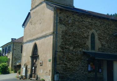
Magnifique circuit empruntant d'abord un petit parcours "Art et Nature" puis se développant à travers collines et campagne, le long de ruisseaux tumultueux. Un petit détour permet de passer par l'église ND de Verdale, accrochée le long de la falaise bordant le Tolerme.
Localisation
Pays :
France
Région :
Occitanie
Département/Province :
Lot
Commune :
Latouille-Lentillac
Localité :
Unknown
Départ:(Dec)
Départ:(UTM)
418136 ; 4967289 (31T) N.
Commentaires
Randonnées à proximité
![Randonnée Marche Ladirat - vallée heureuse - Photo](https://media.geolcdn.com/t/375/260/c06784b0-0d78-47b8-aac1-f9b3521abf51.jpg&format=jpg&maxdim=2)
![Marche Marche](https://static1.geolcdn.com/sitytour/trail-icons/101.png)
vallée heureuse
Marche
Difficile
Ladirat,
Occitanie,
Lot,
France
![](/images/other/stat-length.png)
12,8 km | 17,8 km-effort
3h 21min
![](https://static1.geolcdn.com/siteimages/upload/files/16400158638029165_repeat_loop_refresh_sync_direction_icon.png)
Oui
![Randonnée Marche Latouille-Lentillac - Arts nature 🏞 Latouille Lentillac - Photo](https://media.geolcdn.com/t/375/260/c159d4e3-bd24-4c47-aa99-b15a7786371b.jpg&format=jpg&maxdim=2)
![Marche Marche](https://static1.geolcdn.com/sitytour/trail-icons/101.png)
Arts nature 🏞 Latouille Lentillac
Marche
Très facile
Latouille-Lentillac,
Occitanie,
Lot,
France
![](/images/other/stat-length.png)
1,9 km | 3 km-effort
1h 30min
![](https://static1.geolcdn.com/siteimages/upload/files/16400158638029165_repeat_loop_refresh_sync_direction_icon.png)
Oui
![Randonnée Voiture Saint-Laurent-les-Tours - 45 - Photo](https://media.geolcdn.com/t/375/260/ext.jpg?maxdim=2&url=https%3A%2F%2Fstatic1.geolcdn.com%2Fsiteimages%2Fupload%2Ffiles%2F15247431544x4.jpg)
![Voiture Voiture](https://static1.geolcdn.com/sitytour/trail-icons/401.png)
45
Voiture
Très facile
Saint-Laurent-les-Tours,
Occitanie,
Lot,
France
![](/images/other/stat-length.png)
15,3 km | 19,7 km-effort
55min
![](https://static1.geolcdn.com/siteimages/upload/files/16400158638029165_repeat_loop_refresh_sync_direction_icon.png)
Non
![Randonnée Marche Latouille-Lentillac - Les trois églises - Photo](https://media.geolcdn.com/t/375/260/ext.jpg?maxdim=2&url=https%3A%2F%2Fstatic1.geolcdn.com%2Fsiteimages%2Fupload%2Ffiles%2F1553511878bg_sport_marche.png)
![Marche Marche](https://static1.geolcdn.com/sitytour/trail-icons/101.png)
Les trois églises
Marche
Facile
Latouille-Lentillac,
Occitanie,
Lot,
France
![](/images/other/stat-length.png)
13,5 km | 21 km-effort
3h 55min
![](https://static1.geolcdn.com/siteimages/upload/files/16400158638029165_repeat_loop_refresh_sync_direction_icon.png)
Oui
![Randonnée Vélo Saint-Laurent-les-Tours - Saint Laurent les tour - Photo](https://media.geolcdn.com/t/375/260/ext.jpg?maxdim=2&url=https%3A%2F%2Fstatic1.geolcdn.com%2Fsiteimages%2Fupload%2Ffiles%2F1524743154velo.jpg)
![Vélo Vélo](https://static1.geolcdn.com/sitytour/trail-icons/200.png)
Saint Laurent les tour
Vélo
Très facile
Saint-Laurent-les-Tours,
Occitanie,
Lot,
France
![](/images/other/stat-length.png)
15,8 km | 17,6 km-effort
1h 2min
![](https://static1.geolcdn.com/siteimages/upload/files/16400158638029165_repeat_loop_refresh_sync_direction_icon.png)
Non
![Randonnée Marche Latouille-Lentillac - La touille - Photo](https://media.geolcdn.com/t/375/260/ext.jpg?maxdim=2&url=https%3A%2F%2Fstatic1.geolcdn.com%2Fsiteimages%2Fupload%2Ffiles%2F1553511878bg_sport_marche.png)
![Marche Marche](https://static1.geolcdn.com/sitytour/trail-icons/101.png)
La touille
Marche
Difficile
Latouille-Lentillac,
Occitanie,
Lot,
France
![](/images/other/stat-length.png)
12 km | 17,9 km-effort
3h 47min
![](https://static1.geolcdn.com/siteimages/upload/files/16400158638029165_repeat_loop_refresh_sync_direction_icon.png)
Oui
![Randonnée Marche Sousceyrac-en-Quercy - Autour de Lacamvieille - Photo](https://media.geolcdn.com/t/375/260/ext.jpg?maxdim=2&url=https%3A%2F%2Fstatic1.geolcdn.com%2Fsiteimages%2Fupload%2Ffiles%2F1553511878bg_sport_marche.png)
![Marche Marche](https://static1.geolcdn.com/sitytour/trail-icons/101.png)
Autour de Lacamvieille
Marche
Moyen
Sousceyrac-en-Quercy,
Occitanie,
Lot,
France
![](/images/other/stat-length.png)
9 km | 11,4 km-effort
2h 5min
![](https://static1.geolcdn.com/siteimages/upload/files/16400158638029165_repeat_loop_refresh_sync_direction_icon.png)
Oui