![](/images/other/stat-length.png)
![Randonnée Marche Harréville-les-Chanteurs - de HARÉVILLE- LES-CHANTEURS à SAINT-THIÉBAULT en longeant la Meuse - Photo](https://media.geolcdn.com/t/1900/400/86e7ede6-c709-47c4-851f-73678f8ca86b.jpg&format=pjpeg&maxdim=2)
de HARÉVILLE- LES-CHANTEURS à SAINT-THIÉBAULT en longeant la Meuse
jeannine grandjean
Utilisateur
![Longueur](/images/other/stat-length.png)
![Altitude max](https://static1.geolcdn.com/siteimages/upload/files/1508320355ic_sort_altitude_max_24dp.png)
![Dénivelé positif](https://static1.geolcdn.com/siteimages/upload/files/1508320355ic_sort_den_pos_24dp.png)
![Km-Effort](/images/other/stat-length.png)
![Altitude min](https://static1.geolcdn.com/siteimages/upload/files/1508320355ic_sort_altitude_min_24dp.png)
![Dénivelé négatif](https://static1.geolcdn.com/siteimages/upload/files/1508320355ic_sort_den_neg_24dp.png)
![Boucle](https://static1.geolcdn.com/siteimages/upload/files/16400158638029165_repeat_loop_refresh_sync_direction_icon.png)
![Marche](https://static1.geolcdn.com/sitytour/trail-icons/101.png)
3h06
Difficulté : Facile
![Scannez ce code QR pour ouvrir la randonnée dans l'application SityTrail](https://capi.geolives.com/qq0zvz2zws4bq2lad0pu/sitytour/trails/3052041/qr.png?size=200)
Application GPS de randonnée GRATUITE
À propos
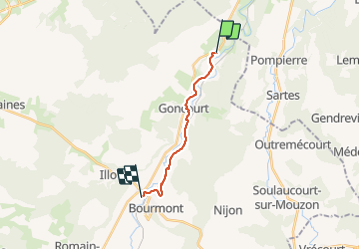
Randonnée Marche de 11,1 km à découvrir à Grand Est, Haute-Marne, Harréville-les-Chanteurs. Cette randonnée est proposée par jeannine grandjean.
Description
très agréable randonnée, sur des chemins praticables et bien balisés
avant d'arriver à Goncourt, on quitte le chemin pour longer le bois dans un champ
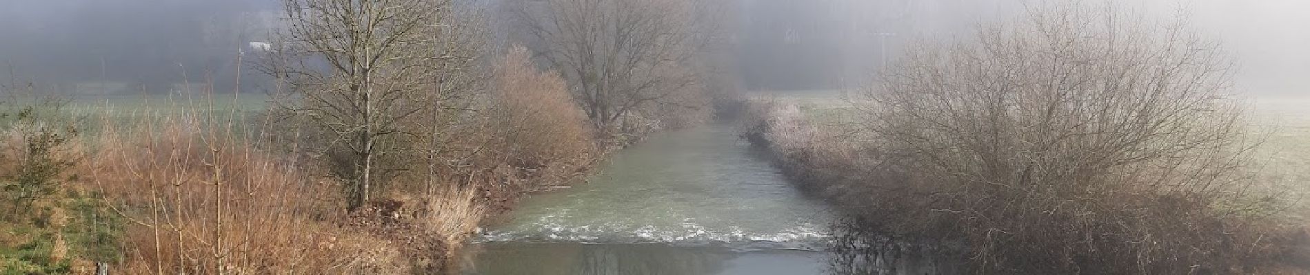
à la sortie de Goncourt, bien suivre le balisage pour découvrir le petit ruisseau (attention : le chemin qui le longe passe sous la voie ferrée et est impraticable quand l'eau a monté... )
ne pas manquer le lavoir à Gonaincourt et son superbe point de vue sur la vallée
entre Gonaincourt et Saint-Thiébault, jolis panoramas sur Bourmont, petite cité de caractère
Localisation
Commentaires
Randonnées à proximité
![Randonnée Marche Bourmont-entre-Meuse-et-Mouzon - GONCOURT :ENTRE GONCOURT ET HARRÉVILLE LES CHANTEURS - Photo](https://media.geolcdn.com/t/375/260/ext.jpg?maxdim=2&url=https%3A%2F%2Fstatic1.geolcdn.com%2Fsiteimages%2Fupload%2Ffiles%2F1553511878bg_sport_marche.png)
![Marche Marche](https://static1.geolcdn.com/sitytour/trail-icons/101.png)
Marche
![](/images/other/stat-length.png)
![](https://static1.geolcdn.com/siteimages/upload/files/16400158638029165_repeat_loop_refresh_sync_direction_icon.png)
![Randonnée V.T.C. Harréville-les-Chanteurs - Les bords de Meuse - Photo](https://media.geolcdn.com/t/375/260/ext.jpg?maxdim=2&url=https%3A%2F%2Fstatic1.geolcdn.com%2Fsiteimages%2Fupload%2Ffiles%2F1524743154velo.jpg)
![V.T.C. V.T.C.](https://static1.geolcdn.com/sitytour/trail-icons/203.png)
V.T.C.
![](/images/other/stat-length.png)
![](https://static1.geolcdn.com/siteimages/upload/files/16400158638029165_repeat_loop_refresh_sync_direction_icon.png)
![Randonnée Marche Pompierre - MJW 4-5 - Photo](https://media.geolcdn.com/t/375/260/ext.jpg?maxdim=2&url=https%3A%2F%2Fstatic1.geolcdn.com%2Fsiteimages%2Fupload%2Ffiles%2F1553511878bg_sport_marche.png)
![Marche Marche](https://static1.geolcdn.com/sitytour/trail-icons/101.png)