![](/images/other/stat-length.png)
![Randonnée Marche Deshaies - du Morne Mazeau jusqu'à la plage de Cluny (littoral) - Photo](https://media.geolcdn.com/t/1900/400/ext.pjpeg?maxdim=2&url=https%3A%2F%2Fstatic1.geolcdn.com%2Fsiteimages%2Fupload%2Ffiles%2F1553511878bg_sport_marche.png)
du Morne Mazeau jusqu'à la plage de Cluny (littoral)
Jo-Guide
Utilisateur
![Longueur](/images/other/stat-length.png)
Longueur
15,4 km
![Altitude max](https://static1.geolcdn.com/siteimages/upload/files/1508320355ic_sort_altitude_max_24dp.png)
Altitude max
639 m
![Dénivelé positif](https://static1.geolcdn.com/siteimages/upload/files/1508320355ic_sort_den_pos_24dp.png)
Dénivelé positif
252 m
![Km-Effort](/images/other/stat-length.png)
Km-Effort
20 km
![Altitude min](https://static1.geolcdn.com/siteimages/upload/files/1508320355ic_sort_altitude_min_24dp.png)
Altitude min
0 m
![Dénivelé négatif](https://static1.geolcdn.com/siteimages/upload/files/1508320355ic_sort_den_neg_24dp.png)
Dénivelé négatif
687 m
![Boucle](https://static1.geolcdn.com/siteimages/upload/files/16400158638029165_repeat_loop_refresh_sync_direction_icon.png)
Boucle
Non
Date de création :
2022-01-09 23:13:40.739
Dernière modification :
2022-02-04 14:23:04.046
![Marche](https://static1.geolcdn.com/sitytour/trail-icons/101.png)
4h35
Difficulté : Très difficile
![Scannez ce code QR pour ouvrir la randonnée dans l'application SityTrail](https://capi.geolives.com/qq0zvz2zws4bq2lad0pu/sitytour/trails/3046649/qr.png?size=200)
Application GPS de randonnée GRATUITE
À propos
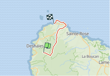
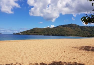
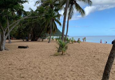
Randonnée Marche de 15,4 km à découvrir à Guadeloupe, Inconnu, Deshaies. Cette randonnée est proposée par Jo-Guide.
Description
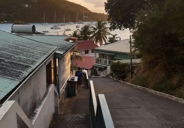
Du Morne Mazeau jusqu'à la plage de Cluny en passant par la trace de la Solitude.
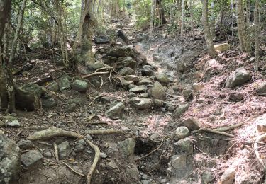
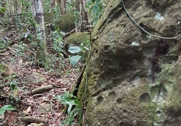
Découverte de la forêt mésophile en moyenne altitude, passage sur la fin du GR R1, et du sentier littoral de la plage des Amandiers jusqu'à la plage Cluny.
Localisation
Pays :
France
Région :
Guadeloupe
Département/Province :
Inconnu
Commune :
Deshaies
Localité :
Unknown
Départ:(Dec)
Départ:(UTM)
630931 ; 1801584 (20Q) N.
Commentaires
Randonnées à proximité
![Randonnée Marche Deshaies - Guadeloupe - Littoral Deshaies - Photo](https://media.geolcdn.com/t/375/260/bcb28dd1-c54b-41be-9fc1-c13c2024c9e1.jpg&format=jpg&maxdim=2)
![Marche Marche](https://static1.geolcdn.com/sitytour/trail-icons/101.png)
Guadeloupe - Littoral Deshaies
Marche
Moyen
Deshaies,
Guadeloupe,
Inconnu,
France
![](/images/other/stat-length.png)
6,1 km | 9,4 km-effort
2h 7min
![](https://static1.geolcdn.com/siteimages/upload/files/16400158638029165_repeat_loop_refresh_sync_direction_icon.png)
Oui
![Randonnée Marche Deshaies - deshaies - Photo](https://media.geolcdn.com/t/375/260/3b0f8b04-6184-41f1-a4d7-c2cf5d9a0dc6.jpg&format=jpg&maxdim=2)
![Marche Marche](https://static1.geolcdn.com/sitytour/trail-icons/101.png)
![Randonnée A pied Sainte-Rose - Solitude - Photo](https://media.geolcdn.com/t/375/260/ext.jpg?maxdim=2&url=https%3A%2F%2Fstatic1.geolcdn.com%2Fsiteimages%2Fupload%2Ffiles%2F1545311037marcheuse_200dpi.jpg)
![A pied A pied](https://static1.geolcdn.com/sitytour/trail-icons/100.png)
![Randonnée Marche Pointe-Noire - beau soleil trou caverne - Photo](https://media.geolcdn.com/t/375/260/fbcae0b9-706e-4ce3-be6d-bc40baafade5.jpg&format=jpg&maxdim=2)
![Marche Marche](https://static1.geolcdn.com/sitytour/trail-icons/101.png)
beau soleil trou caverne
Marche
Moyen
Pointe-Noire,
Guadeloupe,
Inconnu,
France
![](/images/other/stat-length.png)
5,1 km | 10 km-effort
3h 3min
![](https://static1.geolcdn.com/siteimages/upload/files/16400158638029165_repeat_loop_refresh_sync_direction_icon.png)
Oui
![Randonnée Marche Deshaies - site du boing - Photo](https://media.geolcdn.com/t/375/260/ext.jpg?maxdim=2&url=https%3A%2F%2Fstatic1.geolcdn.com%2Fsiteimages%2Fupload%2Ffiles%2F1553511878bg_sport_marche.png)
![Marche Marche](https://static1.geolcdn.com/sitytour/trail-icons/101.png)
site du boing
Marche
Très difficile
Deshaies,
Guadeloupe,
Inconnu,
France
![](/images/other/stat-length.png)
15,1 km | 22 km-effort
10h 56min
![](https://static1.geolcdn.com/siteimages/upload/files/16400158638029165_repeat_loop_refresh_sync_direction_icon.png)
Non
![Randonnée Marche Pointe-Noire - Belle hôtesse l îlet - Photo](https://media.geolcdn.com/t/375/260/ext.jpg?maxdim=2&url=https%3A%2F%2Fstatic1.geolcdn.com%2Fsiteimages%2Fupload%2Ffiles%2F1553511878bg_sport_marche.png)
![Marche Marche](https://static1.geolcdn.com/sitytour/trail-icons/101.png)
Belle hôtesse l îlet
Marche
Pointe-Noire,
Guadeloupe,
Inconnu,
France
![](/images/other/stat-length.png)
9,8 km | 17,8 km-effort
5h 12min
![](https://static1.geolcdn.com/siteimages/upload/files/16400158638029165_repeat_loop_refresh_sync_direction_icon.png)
Non
![Randonnée Marche Deshaies - Deshaies _ Sentier côtier - Photo](https://media.geolcdn.com/t/375/260/c761eac1-80ea-4ba7-90ea-279ee72cd901.jpg&format=jpg&maxdim=2)
![Marche Marche](https://static1.geolcdn.com/sitytour/trail-icons/101.png)
Deshaies _ Sentier côtier
Marche
Facile
Deshaies,
Guadeloupe,
Inconnu,
France
![](/images/other/stat-length.png)
10,8 km | 17,2 km-effort
3h 50min
![](https://static1.geolcdn.com/siteimages/upload/files/16400158638029165_repeat_loop_refresh_sync_direction_icon.png)
Oui
![Randonnée Marche Pointe-Noire - Belle hôtesse - Photo](https://media.geolcdn.com/t/375/260/ext.jpg?maxdim=2&url=https%3A%2F%2Fstatic1.geolcdn.com%2Fsiteimages%2Fupload%2Ffiles%2F1553511878bg_sport_marche.png)
![Marche Marche](https://static1.geolcdn.com/sitytour/trail-icons/101.png)
![Randonnée Course à pied Deshaies - Grand anse - Photo](https://media.geolcdn.com/t/375/260/a52461cf-9a7c-4c5a-b8e0-fb3a5e0f4bc0.jpg&format=jpg&maxdim=2)
![Course à pied Course à pied](https://static1.geolcdn.com/sitytour/trail-icons/103.png)
Grand anse
Course à pied
Moyen
Deshaies,
Guadeloupe,
Inconnu,
France
![](/images/other/stat-length.png)
5,8 km | 6,4 km-effort
57min
![](https://static1.geolcdn.com/siteimages/upload/files/16400158638029165_repeat_loop_refresh_sync_direction_icon.png)
Oui