Randonnée Vélo Auriol - Plan d'aups par le vallon du Peyruis - Photo

Plan d'aups par le vallon du Peyruis

 cyclopat42600
cyclopat42600

Utilisateur

© OpenStreetMap contributors
Longueur
Longueur
37 km
Altitude max
Altitude max
738 m
Dénivelé positif
Dénivelé positif
777 m
Km-Effort
Km-Effort  
48 km
Altitude min
Altitude min
205 m
Dénivelé négatif
Dénivelé négatif
786 m
Boucle
Boucle
Oui
Date de création :
2014-12-10 00:00:00.0
Dernière modification :
2014-12-10 00:00:00.0

(0 Avis)

Vélo
Vélo
2h46
Difficulté : Moyen

Scannez ce code QR pour ouvrir la randonnée dans l'application SityTrail

Application GPS de randonnée GRATUITE

Logo SityTrail SityTrail

IGN / Instituts géographiques

Télécharger SityTrail sur l'App Store Télécharger SityTrail sur Google Play

Logo SityTrail SityTrail World

Le monde est à vous

Télécharger SityTrail sur l'App Store Télécharger SityTrail sur Google Play Télécharger SityTrail sur Huawei AppGallery

À propos

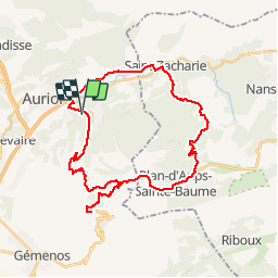
Randonnée Vélo de 37 km à découvrir à Provence-Alpes-Côte d'Azur, Bouches-du-Rhône, Auriol. Cette randonnée est proposée par cyclopat42600.

Description

Petite boucle dans le massif de la Sainte Baume avec un crochet par le col de l'Espigoulier

Profil altimétrique

Localisation

Pays :
France
Région :
Provence-Alpes-Côte d'Azur
Département/Province :
Bouches-du-Rhône
Commune :
Auriol
Localité :
Unknown
Départ:(Dec)
Départ:(UTM)
715195 ; 4804340 (31T) N.

Randonnées à proximité

Randonnée Marche Auriol - la crete des infernets - Photo
Marche
Coryphene

Marche

Difficile
(1)
Auriol, Provence-Alpes-Côte d'Azur, Bouches-du-Rhône, France
8,6 km | 14 km-effort
3h 22min
Oui
Randonnée Marche Plan-d'Aups-Sainte-Baume - La Grotte aux oiseaux - Plan d'Aups  - Photo
Marche
tracegps

Marche

Moyen
(1)
Plan-d'Aups-Sainte-Baume, Provence-Alpes-Côte d'Azur, Var, France
8,8 km | 12,5 km-effort
2h 30min
Oui
Randonnée A pied Auriol - Les moulins - Photo
A pied
PRO

A pied

Facile
Auriol, Provence-Alpes-Côte d'Azur, Bouches-du-Rhône, France
3,7 km | 4,2 km-effort
57min
Oui
Randonnée Marche Auriol - le ravin des Encanaux - Photo
Marche
GUIDE
amiral13

Marche

Difficile
Auriol, Provence-Alpes-Côte d'Azur, Bouches-du-Rhône, France
7,3 km | 12,2 km-effort
3h 10min
Oui
Randonnée Marche Plan-d'Aups-Sainte-Baume - Pic de Bertagne - Grotte Betton - Le plan d'aups - Photo
Marche
GUIDE
affinetataille

Marche

Moyen
Plan-d'Aups-Sainte-Baume, Provence-Alpes-Côte d'Azur, Var, France
9,9 km | 15,7 km-effort
3h 30min
Oui
Randonnée Marche Auriol - Les Encanaux, Auriol-05-06-24 - Photo
Marche
Christiancordin

Marche

Moyen
Auriol, Provence-Alpes-Côte d'Azur, Bouches-du-Rhône, France
15,4 km | 24 km-effort
4h 9min
Oui
Randonnée Marche Auriol - les Encanaux  - Photo
Marche
cousam

Marche

Difficile
Auriol, Provence-Alpes-Côte d'Azur, Bouches-du-Rhône, France
7,1 km | 11 km-effort
2h 14min
Oui
Randonnée Marche Plan-d'Aups-Sainte-Baume - Plan f’aups - Photo
Marche
gaggiroland

Marche

Difficile
Plan-d'Aups-Sainte-Baume, Provence-Alpes-Côte d'Azur, Var, France
10 km | 14,3 km-effort
4h 48min
Oui
Randonnée Marche Auriol - Ravin des Infernets -Tête de chien - Photo
Marche
cousam

Marche

Très difficile
Auriol, Provence-Alpes-Côte d'Azur, Bouches-du-Rhône, France
13,7 km | 22 km-effort
9h 33min
Oui


Fermer
Mes abonnements