![](/images/other/stat-length.png)
![Randonnée A pied Braine-l'Alleud - chemins Braine-l'Alleud-Ophain - Photo](https://media.geolcdn.com/t/1900/400/c49ef0f2-ed92-4446-9ba7-33877595333f.jpg&format=pjpeg&maxdim=2)
chemins Braine-l'Alleud-Ophain
piteur1420
Utilisateur
![Longueur](/images/other/stat-length.png)
Longueur
13,5 km
![Altitude max](https://static1.geolcdn.com/siteimages/upload/files/1508320355ic_sort_altitude_max_24dp.png)
Altitude max
145 m
![Dénivelé positif](https://static1.geolcdn.com/siteimages/upload/files/1508320355ic_sort_den_pos_24dp.png)
Dénivelé positif
213 m
![Km-Effort](/images/other/stat-length.png)
Km-Effort
16,4 km
![Altitude min](https://static1.geolcdn.com/siteimages/upload/files/1508320355ic_sort_altitude_min_24dp.png)
Altitude min
78 m
![Dénivelé négatif](https://static1.geolcdn.com/siteimages/upload/files/1508320355ic_sort_den_neg_24dp.png)
Dénivelé négatif
214 m
![Boucle](https://static1.geolcdn.com/siteimages/upload/files/16400158638029165_repeat_loop_refresh_sync_direction_icon.png)
Boucle
Oui
Date de création :
2022-01-08 11:53:59.075
Dernière modification :
2022-01-08 12:15:33.919
![A pied](https://static1.geolcdn.com/sitytour/trail-icons/100.png)
3h43
Difficulté : Facile
![Scannez ce code QR pour ouvrir la randonnée dans l'application SityTrail](https://capi.geolives.com/qq0zvz2zws4bq2lad0pu/sitytour/trails/3044858/qr.png?size=200)
Application GPS de randonnée GRATUITE
À propos
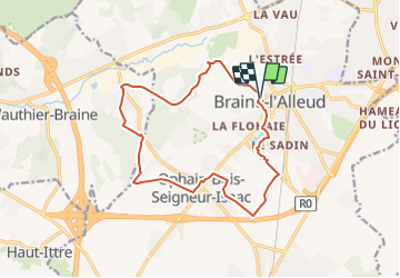
Randonnée A pied de 13,5 km à découvrir à Wallonie, Brabant wallon, Braine-l'Alleud. Cette randonnée est proposée par piteur1420.
Description
Randonnee qui part du centre de Braine-l'Alleud, rejoint Wauthier-Braine et ensuite Ophain et puis retour vers le depart.
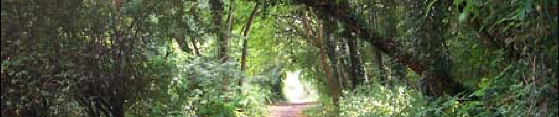
La majorite du parcours se fait par des chemins et petites routes pour eviter la circulation des voitures.
Localisation
Pays :
Belgique
Région :
Wallonie
Département/Province :
Brabant wallon
Commune :
Braine-l'Alleud
Localité :
Braine-l'Alleud
Départ:(Dec)
Départ:(UTM)
596519 ; 5615510 (31U) N.
Commentaires
Randonnées à proximité
![Randonnée Marche Braine-l'Alleud - RB-Bw-13_Braine-l'Alleud - Photo](https://media.geolcdn.com/t/375/260/ext.jpg?maxdim=2&url=https%3A%2F%2Fservices.sitytrail.com%2FGeolivesWS%2FDownloadMedia.ashx%3FTrailID%3D179588%26Media%3D9ffdd7b7-2039-4356-b235-ee33d9a18bd7.jpg)
![Marche Marche](https://static1.geolcdn.com/sitytour/trail-icons/101.png)
RB-Bw-13_Braine-l'Alleud
Marche
Très difficile
(5)
Braine-l'Alleud,
Wallonie,
Brabant wallon,
Belgique
![](/images/other/stat-length.png)
21 km | 27 km-effort
6h 2min
![](https://static1.geolcdn.com/siteimages/upload/files/16400158638029165_repeat_loop_refresh_sync_direction_icon.png)
Oui
![Randonnée Marche Braine-l'Alleud - RB-Bw-13_Braine-l'Alleud_via-racc-1-et-var - Photo](https://media.geolcdn.com/t/375/260/ext.jpg?maxdim=2&url=https%3A%2F%2Fservices.sitytrail.com%2FGeolivesWS%2FDownloadMedia.ashx%3FTrailID%3D220430%26Media%3D9ffdd7b7-2039-4356-b235-ee33d9a18bd7.jpg)
![Marche Marche](https://static1.geolcdn.com/sitytour/trail-icons/101.png)
RB-Bw-13_Braine-l'Alleud_via-racc-1-et-var
Marche
Difficile
(6)
Braine-l'Alleud,
Wallonie,
Brabant wallon,
Belgique
![](/images/other/stat-length.png)
14,8 km | 18,8 km-effort
4h 16min
![](https://static1.geolcdn.com/siteimages/upload/files/16400158638029165_repeat_loop_refresh_sync_direction_icon.png)
Oui
![Randonnée V.T.T. Braine-l'Alleud - O2bikers_58_Waterloo - Photo](https://media.geolcdn.com/t/375/260/ext.jpg?maxdim=2&url=https%3A%2F%2Fstatic1.geolcdn.com%2Fsiteimages%2Fupload%2Ffiles%2F1524743154velo.jpg)
![V.T.T. V.T.T.](https://static1.geolcdn.com/sitytour/trail-icons/202.png)
O2bikers_58_Waterloo
V.T.T.
Très facile
(5)
Braine-l'Alleud,
Wallonie,
Brabant wallon,
Belgique
![](/images/other/stat-length.png)
30 km | 37 km-effort
4h 11min
![](https://static1.geolcdn.com/siteimages/upload/files/16400158638029165_repeat_loop_refresh_sync_direction_icon.png)
Oui
![V.T.T. V.T.T.](https://static1.geolcdn.com/sitytour/trail-icons/202.png)
VTT a plancenoit
V.T.T.
Difficile
(1)
Lasne,
Wallonie,
Brabant wallon,
Belgique
![](/images/other/stat-length.png)
28 km | 34 km-effort
2h 20min
![](https://static1.geolcdn.com/siteimages/upload/files/16400158638029165_repeat_loop_refresh_sync_direction_icon.png)
Oui
![Randonnée V.T.T. Waterloo - De Waterloo à la forêt de Soignes - Photo](https://media.geolcdn.com/t/375/260/ext.jpg?maxdim=2&url=https%3A%2F%2Fservices.sitytrail.com%2FGeolivesWS%2FDownloadMedia.ashx%3FTrailID%3D688453%26Media%3D31ac41f9-68d5-4a4a-9a8e-a882e9787769.JPG)
![V.T.T. V.T.T.](https://static1.geolcdn.com/sitytour/trail-icons/202.png)
De Waterloo à la forêt de Soignes
V.T.T.
Moyen
(1)
Waterloo,
Wallonie,
Brabant wallon,
Belgique
![](/images/other/stat-length.png)
39 km | 47 km-effort
3h 1min
![](https://static1.geolcdn.com/siteimages/upload/files/16400158638029165_repeat_loop_refresh_sync_direction_icon.png)
Oui
![Randonnée Marche Braine-l'Alleud - #221003 - Braine-l'Alleud, Timpe et Tard et Bois du Foriest, Parc et Lac du Paradis**** - Photo](https://media.geolcdn.com/t/375/260/7ca9587d-0fe0-4627-96a6-2d18fe7f584a.jpg&format=jpg&maxdim=2)
![Marche Marche](https://static1.geolcdn.com/sitytour/trail-icons/101.png)
#221003 - Braine-l'Alleud, Timpe et Tard et Bois du Foriest, Parc et Lac du P...
Marche
Moyen
(1)
Braine-l'Alleud,
Wallonie,
Brabant wallon,
Belgique
![](/images/other/stat-length.png)
8,1 km | 9,8 km-effort
2h 13min
![](https://static1.geolcdn.com/siteimages/upload/files/16400158638029165_repeat_loop_refresh_sync_direction_icon.png)
Oui
![Marche Marche](https://static1.geolcdn.com/sitytour/trail-icons/101.png)
RB 11 Plancenoit - Lasnes
Marche
Facile
(1)
Lasne,
Wallonie,
Brabant wallon,
Belgique
![](/images/other/stat-length.png)
12,8 km | 15,6 km-effort
2h 42min
![](https://static1.geolcdn.com/siteimages/upload/files/16400158638029165_repeat_loop_refresh_sync_direction_icon.png)
Oui
![Randonnée Vélo Waterloo - Du Domaine Solvay (Château de La Hulpe + Fondation Folon) à la Butte du Lion - Photo](https://media.geolcdn.com/t/375/260/6e2b14e5-7f01-4b82-86ec-767250ffcdcd.jpg&format=jpg&maxdim=2)
![Vélo Vélo](https://static1.geolcdn.com/sitytour/trail-icons/200.png)
Du Domaine Solvay (Château de La Hulpe + Fondation Folon) à la Butte du Lion
Vélo
Très facile
(2)
Waterloo,
Wallonie,
Brabant wallon,
Belgique
![](/images/other/stat-length.png)
28 km | 32 km-effort
Inconnu
![](https://static1.geolcdn.com/siteimages/upload/files/16400158638029165_repeat_loop_refresh_sync_direction_icon.png)
Non
![Randonnée Marche Braine-l'Alleud - Promenade 1815 - Photo](https://media.geolcdn.com/t/375/260/a5c88808-562a-4352-bf02-99aedd3ac634.jpg&format=jpg&maxdim=2)
![Marche Marche](https://static1.geolcdn.com/sitytour/trail-icons/101.png)
Promenade 1815
Marche
Difficile
(3)
Braine-l'Alleud,
Wallonie,
Brabant wallon,
Belgique
![](/images/other/stat-length.png)
14,4 km | 16,7 km-effort
3h 39min
![](https://static1.geolcdn.com/siteimages/upload/files/16400158638029165_repeat_loop_refresh_sync_direction_icon.png)
Oui