![](/images/other/stat-length.png)
![Randonnée Marche Crest - Crest - Photo](https://media.geolcdn.com/t/1900/400/e9e06745-c5f4-4002-b953-5ca3b3c4882f.jpg&format=pjpeg&maxdim=2)
Crest
Valgaudemar
Utilisateur
![Longueur](/images/other/stat-length.png)
![Altitude max](https://static1.geolcdn.com/siteimages/upload/files/1508320355ic_sort_altitude_max_24dp.png)
![Dénivelé positif](https://static1.geolcdn.com/siteimages/upload/files/1508320355ic_sort_den_pos_24dp.png)
![Km-Effort](/images/other/stat-length.png)
![Altitude min](https://static1.geolcdn.com/siteimages/upload/files/1508320355ic_sort_altitude_min_24dp.png)
![Dénivelé négatif](https://static1.geolcdn.com/siteimages/upload/files/1508320355ic_sort_den_neg_24dp.png)
![Boucle](https://static1.geolcdn.com/siteimages/upload/files/16400158638029165_repeat_loop_refresh_sync_direction_icon.png)
![Marche](https://static1.geolcdn.com/sitytour/trail-icons/101.png)
4h18
Difficulté : Moyen
![Scannez ce code QR pour ouvrir la randonnée dans l'application SityTrail](https://capi.geolives.com/qq0zvz2zws4bq2lad0pu/sitytour/trails/3037892/qr.png?size=200)
Application GPS de randonnée GRATUITE
À propos
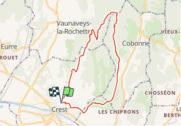
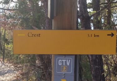
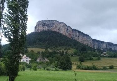
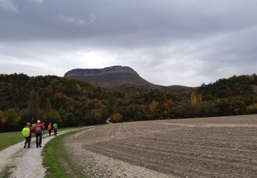
Randonnée Marche de 17,4 km à découvrir à Auvergne-Rhône-Alpes, Drôme, Crest. Cette randonnée est proposée par Valgaudemar.
Description
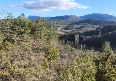
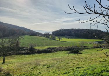
Début avec une montée agréable , sur la crête, avec vue sur la plaine de Valence,
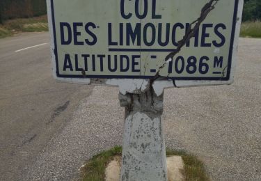
puis à partir des Oullières, le sentier traverse l'enfer
sous la pluie ce passage par l'Enfer est fort bien nommé, une rigole argileuse trempée et glissante, ça patine dans la boue !
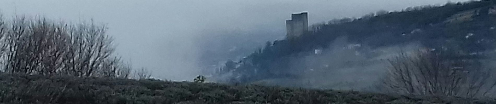
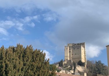
De la Cham jusqu'à Serre Gontard, le chemin est de nouveau sympa, dans la pinède . En descendant vue sur les 3 becs .Retour au Donjon de Crest en longeant des champs de lavande.
Une belle rando en Drôme provençale
Localisation
Commentaires
Randonnées à proximité
![Randonnée Marche Crest - Crest / Col de Bessot - Photo](https://media.geolcdn.com/t/375/260/ext.jpg?maxdim=2&url=https%3A%2F%2Fservices.sitytrail.com%2FGeolivesWS%2FDownloadMedia.ashx%3FTrailID%3D497687%26Media%3Dfix__20151127133911.jpg)
![Marche Marche](https://static1.geolcdn.com/sitytour/trail-icons/101.png)
Marche
![](/images/other/stat-length.png)
![](https://static1.geolcdn.com/siteimages/upload/files/16400158638029165_repeat_loop_refresh_sync_direction_icon.png)
![Randonnée V.T.T. Aouste-sur-Sye - vtt vcs 120922 - Photo](https://media.geolcdn.com/t/375/260/ext.jpg?maxdim=2&url=https%3A%2F%2Fstatic1.geolcdn.com%2Fsiteimages%2Fupload%2Ffiles%2F1524743154velo.jpg)
![V.T.T. V.T.T.](https://static1.geolcdn.com/sitytour/trail-icons/202.png)
V.T.T.
![](/images/other/stat-length.png)
![](https://static1.geolcdn.com/siteimages/upload/files/16400158638029165_repeat_loop_refresh_sync_direction_icon.png)
![Randonnée Marche Aouste-sur-Sye - crête de Saint Alban. Aoust - Photo](https://media.geolcdn.com/t/375/260/638b2452-7773-4948-a643-cae10f47f13f.jpg&format=jpg&maxdim=2)
![Marche Marche](https://static1.geolcdn.com/sitytour/trail-icons/101.png)
Marche
![](/images/other/stat-length.png)
![](https://static1.geolcdn.com/siteimages/upload/files/16400158638029165_repeat_loop_refresh_sync_direction_icon.png)
![Randonnée Marche Crest - Crest à VAUNAVEY - Photo](https://media.geolcdn.com/t/375/260/286137c0-d121-4814-8720-e6aa22e27ac9.jpg&format=jpg&maxdim=2)
![Marche Marche](https://static1.geolcdn.com/sitytour/trail-icons/101.png)
Marche
![](/images/other/stat-length.png)
![](https://static1.geolcdn.com/siteimages/upload/files/16400158638029165_repeat_loop_refresh_sync_direction_icon.png)
![Randonnée Vélo de route Crest - j3 Crest limouche vauna vaunaveys 01.07.23 - Photo](https://media.geolcdn.com/t/375/260/f1e7664d-d94c-4a24-8662-9bd9acc5deea.jpg&format=jpg&maxdim=2)
![Vélo de route Vélo de route](https://static1.geolcdn.com/sitytour/trail-icons/201.png)
Vélo de route
![](/images/other/stat-length.png)
![](https://static1.geolcdn.com/siteimages/upload/files/16400158638029165_repeat_loop_refresh_sync_direction_icon.png)
![Randonnée Marche Crest - Crest les crêtes - Photo](https://media.geolcdn.com/t/375/260/d13859cb-c499-4b0f-86ce-a9a52bdb88e9.jpg&format=jpg&maxdim=2)
![Marche Marche](https://static1.geolcdn.com/sitytour/trail-icons/101.png)
Marche
![](/images/other/stat-length.png)
![](https://static1.geolcdn.com/siteimages/upload/files/16400158638029165_repeat_loop_refresh_sync_direction_icon.png)
![Randonnée V.T.C. Crest - Crest, Plan de Baix - Photo](https://media.geolcdn.com/t/375/260/0e76bb24-ea99-405f-9c69-9944f9251d1b.jpg&format=jpg&maxdim=2)
![V.T.C. V.T.C.](https://static1.geolcdn.com/sitytour/trail-icons/203.png)
V.T.C.
![](/images/other/stat-length.png)
![](https://static1.geolcdn.com/siteimages/upload/files/16400158638029165_repeat_loop_refresh_sync_direction_icon.png)
![Randonnée Marche Crest - crest vierge divajeu hubat aouste - Photo](https://media.geolcdn.com/t/375/260/ee289172-6359-4811-9efa-2c8394fcdbfd.jpg&format=jpg&maxdim=2)
![Marche Marche](https://static1.geolcdn.com/sitytour/trail-icons/101.png)
Marche
![](/images/other/stat-length.png)
![](https://static1.geolcdn.com/siteimages/upload/files/16400158638029165_repeat_loop_refresh_sync_direction_icon.png)
![Randonnée V.T.T. Crest - pas de lauzun vtt - Photo](https://media.geolcdn.com/t/375/260/ext.jpg?maxdim=2&url=https%3A%2F%2Fstatic1.geolcdn.com%2Fsiteimages%2Fupload%2Ffiles%2F1524743154velo.jpg)
![V.T.T. V.T.T.](https://static1.geolcdn.com/sitytour/trail-icons/202.png)
V.T.T.
![](/images/other/stat-length.png)
![](https://static1.geolcdn.com/siteimages/upload/files/16400158638029165_repeat_loop_refresh_sync_direction_icon.png)