![](/images/other/stat-length.png)
![Randonnée Marche Looz - L’église transparente de Borgloon - Photo](https://media.geolcdn.com/t/1900/400/96e4ef37-d90b-4cff-9592-9cc493e05142.jpg&format=pjpeg&maxdim=2)
L’église transparente de Borgloon
Au fil de nos découvertes
« L’heure de la fin des découvertes ne sonne jamais. » Colette GUIDE+
![Longueur](/images/other/stat-length.png)
![Altitude max](https://static1.geolcdn.com/siteimages/upload/files/1508320355ic_sort_altitude_max_24dp.png)
![Dénivelé positif](https://static1.geolcdn.com/siteimages/upload/files/1508320355ic_sort_den_pos_24dp.png)
![Km-Effort](/images/other/stat-length.png)
![Altitude min](https://static1.geolcdn.com/siteimages/upload/files/1508320355ic_sort_altitude_min_24dp.png)
![Dénivelé négatif](https://static1.geolcdn.com/siteimages/upload/files/1508320355ic_sort_den_neg_24dp.png)
![Boucle](https://static1.geolcdn.com/siteimages/upload/files/16400158638029165_repeat_loop_refresh_sync_direction_icon.png)
![Marche](https://static1.geolcdn.com/sitytour/trail-icons/101.png)
2h14
Difficulté : Moyen
![Scannez ce code QR pour ouvrir la randonnée dans l'application SityTrail](https://capi.geolives.com/qq0zvz2zws4bq2lad0pu/sitytour/trails/3036452/qr.png?size=200)
Application GPS de randonnée GRATUITE
À propos
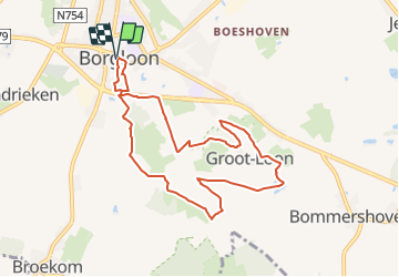
Randonnée Marche de 8,2 km à découvrir à Flandre, Limbourg, Looz. Cette randonnée est proposée par Au fil de nos découvertes.
Description
🅿️ Départ et Parking:
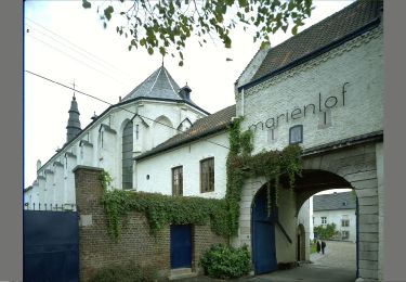
Sint-Odulfuskerk
Speelhof
3840 Borgloon
Départ de l’arrêt de bus « Speelhof »
▶️ Suivre la balise « croix orange »
🌲🌳
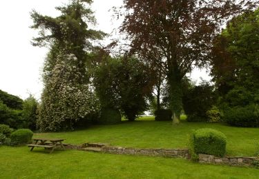
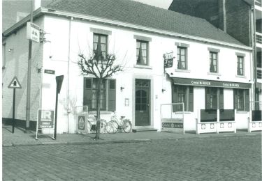
Premièrement, n’hésitez pas à aller faire un petit tour dans le village, car il est vraiment charmant ! 😍
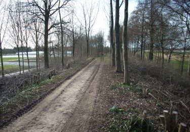
Vous traverserez de nombreux vergers. 🌽🍎🍏
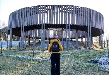
Quelques œuvres d’art sont dispersées le long de la promenade. 🎨
⚠️ Lorsque vous aurez traversé le tunnel, les balises vont à gauche ou à droite. Si vous allez à gauche vous arriverez directement à l’église.
Mais pas de souci à se faire, que vous alliez à droite ou à gauche, vous la verrez !
Vous pouvez également vous rendre simplement à l’église, mais vous devez vous garer avant et marcher jusque-là. C’est facilement accessible.
Possibilités de pic-niquer. 🥪🍴
Chiens autorisés en laisse. 🐩🐶🐕
Convient pour les enfants . 👱👱♂️
Ne convient pas pour les poussettes et personnes à mobilité réduite. 👨🦽👩🦽👶
Localisation
Commentaires
Randonnées à proximité
![Randonnée Marche Looz - Promenade vers l'Aeneas Wilder - Photo](https://media.geolcdn.com/t/375/260/8625d454-03fc-46d2-bafa-261470717766.jpg&format=jpg&maxdim=2)
![Marche Marche](https://static1.geolcdn.com/sitytour/trail-icons/101.png)
Marche
![](/images/other/stat-length.png)
![](https://static1.geolcdn.com/siteimages/upload/files/16400158638029165_repeat_loop_refresh_sync_direction_icon.png)
![Randonnée Marche Looz - randonnee de l eglise fantôme (doorkijkkerkje) - Photo](https://media.geolcdn.com/t/375/260/35833fe8-8dcf-4404-b0af-d88e0896892e.jpg&format=jpg&maxdim=2)
![Marche Marche](https://static1.geolcdn.com/sitytour/trail-icons/101.png)
Marche
![](/images/other/stat-length.png)
![](https://static1.geolcdn.com/siteimages/upload/files/16400158638029165_repeat_loop_refresh_sync_direction_icon.png)
![Randonnée A pied Kortessem - La vallée du ruisseau Sint-Anna à Zammelen - Photo](https://media.geolcdn.com/t/375/260/fc718cb3-95ec-485f-a77f-edadc1be0696.jpeg&format=jpg&maxdim=2)
![A pied A pied](https://static1.geolcdn.com/sitytour/trail-icons/100.png)
A pied
![](/images/other/stat-length.png)
![](https://static1.geolcdn.com/siteimages/upload/files/16400158638029165_repeat_loop_refresh_sync_direction_icon.png)
![Randonnée A pied Tongres - Rond de bronnen van de Mombeek - Photo](https://media.geolcdn.com/t/375/260/13e3acb7-2467-4a11-bfa7-f876dab6b0eb.jpeg&format=jpg&maxdim=2)
![A pied A pied](https://static1.geolcdn.com/sitytour/trail-icons/100.png)
A pied
![](/images/other/stat-length.png)
![](https://static1.geolcdn.com/siteimages/upload/files/16400158638029165_repeat_loop_refresh_sync_direction_icon.png)
![Randonnée A pied Tongres - Widooie - Photo](https://media.geolcdn.com/t/375/260/1460d0c9-37d5-4e75-86eb-ce79ff244b22.jpeg&format=jpg&maxdim=2)
![A pied A pied](https://static1.geolcdn.com/sitytour/trail-icons/100.png)
![Randonnée A pied Looz - Mariënlof Rode pijl - Photo](https://media.geolcdn.com/t/375/260/f9353f39-8b13-4a24-b09a-7fe4cf454715.jpeg&format=jpg&maxdim=2)
![A pied A pied](https://static1.geolcdn.com/sitytour/trail-icons/100.png)
A pied
![](/images/other/stat-length.png)
![](https://static1.geolcdn.com/siteimages/upload/files/16400158638029165_repeat_loop_refresh_sync_direction_icon.png)
![Randonnée A pied Wellen - Alken-Wellen verbinding - Photo](https://media.geolcdn.com/t/375/260/3e82e838-81f6-4f4d-83f3-4708a8447d05.jpeg&format=jpg&maxdim=2)
![A pied A pied](https://static1.geolcdn.com/sitytour/trail-icons/100.png)
A pied
![](/images/other/stat-length.png)
![](https://static1.geolcdn.com/siteimages/upload/files/16400158638029165_repeat_loop_refresh_sync_direction_icon.png)
![Randonnée A pied Kortessem - 3-Bekenroute Eggeringen - Photo](https://media.geolcdn.com/t/375/260/348e48f1-e1dd-48a8-8fb5-7a592d6db187.jpeg&format=jpg&maxdim=2)
![A pied A pied](https://static1.geolcdn.com/sitytour/trail-icons/100.png)
A pied
![](/images/other/stat-length.png)
![](https://static1.geolcdn.com/siteimages/upload/files/16400158638029165_repeat_loop_refresh_sync_direction_icon.png)
![Randonnée A pied Looz - Perenboomgaardwandeling - Photo](https://media.geolcdn.com/t/375/260/83d08ccc-3d46-4f67-87f8-eb2b08e4c23b.jpeg&format=jpg&maxdim=2)
![A pied A pied](https://static1.geolcdn.com/sitytour/trail-icons/100.png)
A pied
![](/images/other/stat-length.png)
![](https://static1.geolcdn.com/siteimages/upload/files/16400158638029165_repeat_loop_refresh_sync_direction_icon.png)
magnifique