Randonnée V.T.T. Montrozier - VTT  de Gages à la forêt des Palanges 38km  - Photo

VTT de Gages à la forêt des Palanges 38km

 Levillefranchois
Levillefranchois

Utilisateur

© OpenStreetMap contributors
Longueur
Longueur
38 km
Altitude max
Altitude max
860 m
Dénivelé positif
Dénivelé positif
681 m
Km-Effort
Km-Effort  
47 km
Altitude min
Altitude min
551 m
Dénivelé négatif
Dénivelé négatif
680 m
Boucle
Boucle
Oui
Date de création :
2021-12-23 15:33:16.672
Dernière modification :
2021-12-23 15:35:58.369

(0 Avis)

V.T.T.
V.T.T.
--
Difficulté : Moyen

Scannez ce code QR pour ouvrir la randonnée dans l'application SityTrail

Application GPS de randonnée GRATUITE

Logo SityTrail SityTrail

IGN / Instituts géographiques

Télécharger SityTrail sur l'App Store Télécharger SityTrail sur Google Play

Logo SityTrail SityTrail World

Le monde est à vous

Télécharger SityTrail sur l'App Store Télécharger SityTrail sur Google Play Télécharger SityTrail sur Huawei AppGallery

À propos

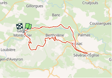
Randonnée V.T.T. de 38 km à découvrir à Occitanie, Aveyron, Montrozier. Cette randonnée est proposée par Levillefranchois.

Description

Parcours très agréable dans l'ensemble et même ludique dans la forêt des Palanges

Profil altimétrique

Localisation

Pays :
France
Région :
Occitanie
Département/Province :
Aveyron
Commune :
Montrozier
Localité :
Unknown
Départ:(UTM)
476767 ; 4916051 (31T) N.

Randonnées à proximité

Randonnée Marche Bozouls - Horizons et Clochers du Rouergue - Gillorgues - Photo
Marche
tracegps

Marche

Moyen
Bozouls, Occitanie, Aveyron, France
11,9 km | 15,5 km-effort
3h 0min
Oui
Randonnée Moto-cross Montrozier - av cl 2024 - Photo
Moto-cross
frank12

Moto-cross

Très facile
Montrozier, Occitanie, Aveyron, France
30 km | 42 km-effort
1h 0min
Non
Randonnée Marche Montrozier - Gages Campeyroux - Photo
Marche
Rere1947

Marche

Montrozier, Occitanie, Aveyron, France
8,4 km | 9,7 km-effort
1h 52min
Oui
Randonnée Marche Bozouls - Gillorgues - Photo
Marche
Lacaze

Marche

Moyen
Bozouls, Occitanie, Aveyron, France
10,9 km | 14,1 km-effort
3h 11min
Oui
Randonnée Marche Montrozier - causse comtal - Photo
Marche
Lacaze

Marche

Facile
Montrozier, Occitanie, Aveyron, France
7 km | 8,1 km-effort
1h 46min
Oui
Randonnée V.T.T. Bozouls - Aboul - Photo
V.T.T.
bonnetchristian

V.T.T.

Très facile
Bozouls, Occitanie, Aveyron, France
5,4 km | 6,9 km-effort
Inconnu
Oui
Randonnée V.T.T. Montrozier - La Combe - Photo
V.T.T.
bonnetchristian

V.T.T.

Très facile
Montrozier, Occitanie, Aveyron, France
4,5 km | 5,4 km-effort
Inconnu
Oui
Randonnée V.T.T. Montrozier - Gages - Photo
V.T.T.
bonnetchristian

V.T.T.

Très facile
Montrozier, Occitanie, Aveyron, France
4,7 km | 6 km-effort
Inconnu
Oui
Randonnée V.T.T. Bozouls - Route de César - Photo
V.T.T.
bonnetchristian

V.T.T.

Très facile
Bozouls, Occitanie, Aveyron, France
6,7 km | 8,4 km-effort
Inconnu
Oui


Fermer
Mes abonnements