![](/images/other/stat-length.png)
![Randonnée V.T.T. Caylus - VTT Caylus 45km - Photo](https://media.geolcdn.com/t/1900/400/ext.pjpeg?maxdim=2&url=https%3A%2F%2Fstatic1.geolcdn.com%2Fsiteimages%2Fupload%2Ffiles%2F1524743154velo.jpg)
VTT Caylus 45km
Levillefranchois
Utilisateur
![Longueur](/images/other/stat-length.png)
Longueur
44 km
![Altitude max](https://static1.geolcdn.com/siteimages/upload/files/1508320355ic_sort_altitude_max_24dp.png)
Altitude max
396 m
![Dénivelé positif](https://static1.geolcdn.com/siteimages/upload/files/1508320355ic_sort_den_pos_24dp.png)
Dénivelé positif
934 m
![Km-Effort](/images/other/stat-length.png)
Km-Effort
57 km
![Altitude min](https://static1.geolcdn.com/siteimages/upload/files/1508320355ic_sort_altitude_min_24dp.png)
Altitude min
196 m
![Dénivelé négatif](https://static1.geolcdn.com/siteimages/upload/files/1508320355ic_sort_den_neg_24dp.png)
Dénivelé négatif
934 m
![Boucle](https://static1.geolcdn.com/siteimages/upload/files/16400158638029165_repeat_loop_refresh_sync_direction_icon.png)
Boucle
Oui
Date de création :
2021-12-23 09:27:46.219
Dernière modification :
2021-12-23 09:30:09.687
![V.T.T.](https://static1.geolcdn.com/sitytour/trail-icons/202.png)
--
Difficulté : Difficile
![Scannez ce code QR pour ouvrir la randonnée dans l'application SityTrail](https://capi.geolives.com/qq0zvz2zws4bq2lad0pu/sitytour/trails/3032520/qr.png?size=200)
Application GPS de randonnée GRATUITE
À propos
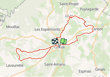
Randonnée V.T.T. de 44 km à découvrir à Occitanie, Tarn-et-Garonne, Caylus. Cette randonnée est proposée par Levillefranchois.
Description
Départ parking du plan d'eau de Labarthe, en direction de St Antonin.
Parcours beau et interessant mais apres de grosses pluies, assez difficile.
Localisation
Pays :
France
Région :
Occitanie
Département/Province :
Tarn-et-Garonne
Commune :
Caylus
Localité :
Unknown
Départ:(Dec)
Départ:(UTM)
401937 ; 4898554 (31T) N.
Commentaires
Randonnées à proximité
![Randonnée Marche Lacapelle-Livron - Lacapelle-Livron : Chemin des anciens moulins, cascade pétrifiante - Photo](https://media.geolcdn.com/t/375/260/ext.jpg?maxdim=2&url=https%3A%2F%2Fmedia.geolcdn.com%2Ff%2F5aa7a560-03f6-4d5e-93e6-5cea9f87d2e7.JPG)
![Marche Marche](https://static1.geolcdn.com/sitytour/trail-icons/101.png)
Lacapelle-Livron : Chemin des anciens moulins, cascade pétrifiante
Marche
Moyen
(1)
Lacapelle-Livron,
Occitanie,
Tarn-et-Garonne,
France
![](/images/other/stat-length.png)
7,2 km | 9,6 km-effort
2h 11min
![](https://static1.geolcdn.com/siteimages/upload/files/16400158638029165_repeat_loop_refresh_sync_direction_icon.png)
Oui
![Randonnée Marche Caylus - caylus 1 - Photo](https://media.geolcdn.com/t/375/260/ext.jpg?maxdim=2&url=https%3A%2F%2Fstatic1.geolcdn.com%2Fsiteimages%2Fupload%2Ffiles%2F1553511878bg_sport_marche.png)
![Marche Marche](https://static1.geolcdn.com/sitytour/trail-icons/101.png)
caylus 1
Marche
Très difficile
Caylus,
Occitanie,
Tarn-et-Garonne,
France
![](/images/other/stat-length.png)
16,3 km | 21 km-effort
2h 44min
![](https://static1.geolcdn.com/siteimages/upload/files/16400158638029165_repeat_loop_refresh_sync_direction_icon.png)
Oui
![Randonnée V.T.T. Saint-Antonin-Noble-Val - baradoy - Photo](https://media.geolcdn.com/t/375/260/ext.jpg?maxdim=2&url=https%3A%2F%2Fstatic1.geolcdn.com%2Fsiteimages%2Fupload%2Ffiles%2F1524743154velo.jpg)
![V.T.T. V.T.T.](https://static1.geolcdn.com/sitytour/trail-icons/202.png)
baradoy
V.T.T.
Moyen
Saint-Antonin-Noble-Val,
Occitanie,
Tarn-et-Garonne,
France
![](/images/other/stat-length.png)
23 km | 27 km-effort
1h 57min
![](https://static1.geolcdn.com/siteimages/upload/files/16400158638029165_repeat_loop_refresh_sync_direction_icon.png)
Non
![Randonnée Marche Caylus - 211115 Rando ARAT Caylus - Photo](https://media.geolcdn.com/t/375/260/ext.jpg?maxdim=2&url=https%3A%2F%2Fstatic1.geolcdn.com%2Fsiteimages%2Fupload%2Ffiles%2F1553511878bg_sport_marche.png)
![Marche Marche](https://static1.geolcdn.com/sitytour/trail-icons/101.png)
211115 Rando ARAT Caylus
Marche
Moyen
Caylus,
Occitanie,
Tarn-et-Garonne,
France
![](/images/other/stat-length.png)
14,8 km | 18,6 km-effort
5h 36min
![](https://static1.geolcdn.com/siteimages/upload/files/16400158638029165_repeat_loop_refresh_sync_direction_icon.png)
Oui
![Randonnée Autre activité Caylus - 12.5 km - Photo](https://media.geolcdn.com/t/375/260/ext.jpg?maxdim=2&url=https%3A%2F%2Fstatic1.geolcdn.com%2Fsiteimages%2Fupload%2Ffiles%2F1545311037marcheuse_200dpi.jpg)
![Autre activité Autre activité](https://static1.geolcdn.com/sitytour/trail-icons/900.png)
12.5 km
Autre activité
Très facile
Caylus,
Occitanie,
Tarn-et-Garonne,
France
![](/images/other/stat-length.png)
15,3 km | 17,9 km-effort
Inconnu
![](https://static1.geolcdn.com/siteimages/upload/files/16400158638029165_repeat_loop_refresh_sync_direction_icon.png)
Oui
![Randonnée Marche nordique Caylus - Caylus MN - Photo](https://media.geolcdn.com/t/375/260/ext.jpg?maxdim=2&url=https%3A%2F%2Fstatic1.geolcdn.com%2Fsiteimages%2Fupload%2Ffiles%2F1545311037marcheuse_200dpi.jpg)
![Marche nordique Marche nordique](https://static1.geolcdn.com/sitytour/trail-icons/102.png)
Caylus MN
Marche nordique
Très facile
Caylus,
Occitanie,
Tarn-et-Garonne,
France
![](/images/other/stat-length.png)
8,4 km | 10 km-effort
Inconnu
![](https://static1.geolcdn.com/siteimages/upload/files/16400158638029165_repeat_loop_refresh_sync_direction_icon.png)
Oui
![Randonnée Marche Saint-Antonin-Noble-Val - la gourous par vivens - Photo](https://media.geolcdn.com/t/375/260/ext.jpg?maxdim=2&url=https%3A%2F%2Fstatic1.geolcdn.com%2Fsiteimages%2Fupload%2Ffiles%2F1553511878bg_sport_marche.png)
![Marche Marche](https://static1.geolcdn.com/sitytour/trail-icons/101.png)
la gourous par vivens
Marche
Moyen
Saint-Antonin-Noble-Val,
Occitanie,
Tarn-et-Garonne,
France
![](/images/other/stat-length.png)
15,2 km | 18,7 km-effort
5h 48min
![](https://static1.geolcdn.com/siteimages/upload/files/16400158638029165_repeat_loop_refresh_sync_direction_icon.png)
Oui
![Randonnée Marche Caylus - Lacapelle Livron- cascade pétrifiante - Photo](https://media.geolcdn.com/t/375/260/ext.jpg?maxdim=2&url=https%3A%2F%2Fstatic1.geolcdn.com%2Fsiteimages%2Fupload%2Ffiles%2F1553511878bg_sport_marche.png)
![Marche Marche](https://static1.geolcdn.com/sitytour/trail-icons/101.png)
Lacapelle Livron- cascade pétrifiante
Marche
Moyen
Caylus,
Occitanie,
Tarn-et-Garonne,
France
![](/images/other/stat-length.png)
8,5 km | 11,1 km-effort
2h 31min
![](https://static1.geolcdn.com/siteimages/upload/files/16400158638029165_repeat_loop_refresh_sync_direction_icon.png)
Oui
![Randonnée sport Caylus - Caylus - CHÔ - Photo](https://media.geolcdn.com/t/375/260/ext.jpg?maxdim=2&url=https%3A%2F%2Fsecurestorage.geolives.com%2Fsitytour%2Ftrail-bg%2Fdefault.jpg)
Caylus - CHÔ
sport
Très facile
Caylus,
Occitanie,
Tarn-et-Garonne,
France
![](/images/other/stat-length.png)
7,7 km | 10,1 km-effort
Inconnu
![](https://static1.geolcdn.com/siteimages/upload/files/16400158638029165_repeat_loop_refresh_sync_direction_icon.png)
Non