![](/images/other/stat-length.png)
![Randonnée Marche Bruges - Bruges - Photo](https://media.geolcdn.com/t/1900/400/c021ff3f-e73e-4620-bed9-0e65728f669d.jpg&format=pjpeg&maxdim=2)
Bruges
mumu.larandonneuse
Utilisateur GUIDE
![Longueur](/images/other/stat-length.png)
![Altitude max](https://static1.geolcdn.com/siteimages/upload/files/1508320355ic_sort_altitude_max_24dp.png)
![Dénivelé positif](https://static1.geolcdn.com/siteimages/upload/files/1508320355ic_sort_den_pos_24dp.png)
![Km-Effort](/images/other/stat-length.png)
![Altitude min](https://static1.geolcdn.com/siteimages/upload/files/1508320355ic_sort_altitude_min_24dp.png)
![Dénivelé négatif](https://static1.geolcdn.com/siteimages/upload/files/1508320355ic_sort_den_neg_24dp.png)
![Boucle](https://static1.geolcdn.com/siteimages/upload/files/16400158638029165_repeat_loop_refresh_sync_direction_icon.png)
![Marche](https://static1.geolcdn.com/sitytour/trail-icons/101.png)
3h01
Difficulté : Très facile
![Scannez ce code QR pour ouvrir la randonnée dans l'application SityTrail](https://capi.geolives.com/qq0zvz2zws4bq2lad0pu/sitytour/trails/3030921/qr.png?size=200)
Application GPS de randonnée GRATUITE
À propos
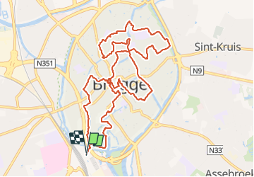
Randonnée Marche de 12,1 km à découvrir à Flandre, Flandre-Occidentale, Bruges. Cette randonnée est proposée par mumu.larandonneuse.
Description
Une rando découverte de la Venise du Nord et son architecture flamande.
Que visiter ?
🔸️Le parc du Minnewater et le lac d'amour.
🔸️Le Béguinage avec ses façades blanches, un espace clos séparé de la ville par un mur d'enceinte encore partiellement doublé de douves.
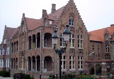
🔸️L'hôpital Saint-Jean (site Oud Sint-Jan) , l'un des plus anciens hôpitaux médiévaux d'Europe. Il est devenu un musée qui, dans la chapelle, conserve notamment six chefs-d'œuvre du peintre Hans Memling.
🔸️Les canaux
🔸️Le Quai du Rosaire (Rozenhoedkaai), l'endroit le plus photographié de Bruges ! C'est l'ancien port de sel de la ville et à présent, un des lieux de départ des balades en bateau sur les canaux.
🔸️La grand place : Le Markt
🔸️Le beffroi, haute tour médiévale surmontant la Halle aux draps sur la Grand-Place.
🔸️Le quartier de la Hanse (ou des loges) qui suit à peu près le canal de la Reie, voie maritime servant autrefois à la livraison et à l’expédition des marchandises.
🔸️Le parc Astrid
🔸️Le Marché aux poissons (Vismarkt), il s’agit de halles en plein air de style néo-classique avec 126 colonnes doubles.
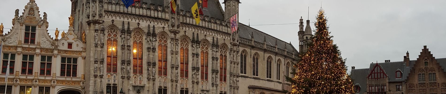
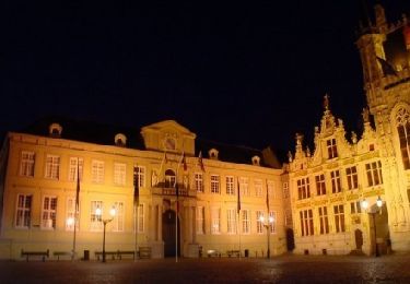
🔸️La place du Bourg (Burg) et l'hôtel de ville, un monument historique datant du 14ème siècle, très richement décoré dans un style gothique flamboyant.
Localisation
Commentaires
Randonnées à proximité
![Randonnée Marche Bruges - Le meilleur de Bruges - Photo](https://media.geolcdn.com/t/375/260/ext.jpg?maxdim=2&url=https%3A%2F%2Fservices.sitytrail.com%2FGeolivesWS%2FDownloadMedia.ashx%3FTrailID%3D544186%26Media%3D180b77e7-3bf1-4890-afa8-613a20f0125b.jpg)
![Marche Marche](https://static1.geolcdn.com/sitytour/trail-icons/101.png)
Marche
![](/images/other/stat-length.png)
![](https://static1.geolcdn.com/siteimages/upload/files/16400158638029165_repeat_loop_refresh_sync_direction_icon.png)
![Randonnée Marche Bruges - Bruges, une ville fière de son Patrimoine mondial - Photo](https://media.geolcdn.com/t/375/260/ext.jpg?maxdim=2&url=https%3A%2F%2Fservices.sitytrail.com%2FGeolivesWS%2FDownloadMedia.ashx%3FTrailID%3D66330%26Media%3D3ea5f1bf-5086-4b42-b388-3be547d8a98c.jpg)
![Marche Marche](https://static1.geolcdn.com/sitytour/trail-icons/101.png)
Marche
![](/images/other/stat-length.png)
![](https://static1.geolcdn.com/siteimages/upload/files/16400158638029165_repeat_loop_refresh_sync_direction_icon.png)
![Randonnée A pied Zuienkerke - Wandeling Meetkerkse Moeren - Photo](https://media.geolcdn.com/t/375/260/3323ba47-6cae-4f07-8b7e-e53b45e217ff.jpeg&format=jpg&maxdim=2)
![A pied A pied](https://static1.geolcdn.com/sitytour/trail-icons/100.png)
A pied
![](/images/other/stat-length.png)
![](https://static1.geolcdn.com/siteimages/upload/files/16400158638029165_repeat_loop_refresh_sync_direction_icon.png)
![Randonnée A pied Bruges - Drie Kastelen Wandelroute - Photo](https://media.geolcdn.com/t/375/260/8ba757f9-e732-4c67-ba6a-cb7a9261b76e.jpeg&format=jpg&maxdim=2)
![A pied A pied](https://static1.geolcdn.com/sitytour/trail-icons/100.png)
A pied
![](/images/other/stat-length.png)
![](https://static1.geolcdn.com/siteimages/upload/files/16400158638029165_repeat_loop_refresh_sync_direction_icon.png)
![Randonnée A pied Oostkamp - Meersen wandelroute - Photo](https://media.geolcdn.com/t/375/260/f2c5a60a-a73e-4cc6-a91f-c7d48fe602b2.jpeg&format=jpg&maxdim=2)
![A pied A pied](https://static1.geolcdn.com/sitytour/trail-icons/100.png)
A pied
![](/images/other/stat-length.png)
![](https://static1.geolcdn.com/siteimages/upload/files/16400158638029165_repeat_loop_refresh_sync_direction_icon.png)
![Randonnée Marche Bruges - GR 129 : Brugge > Beernem - Photo](https://media.geolcdn.com/t/375/260/ext.jpg?maxdim=2&url=https%3A%2F%2Fstatic1.geolcdn.com%2Fsiteimages%2Fupload%2Ffiles%2F1553511878bg_sport_marche.png)
![Marche Marche](https://static1.geolcdn.com/sitytour/trail-icons/101.png)
Marche
![](/images/other/stat-length.png)
![](https://static1.geolcdn.com/siteimages/upload/files/16400158638029165_repeat_loop_refresh_sync_direction_icon.png)
![Randonnée Marche Bruges - Brugge langs beddingen - 5 km RT - Photo](https://media.geolcdn.com/t/375/260/ext.jpg?maxdim=2&url=https%3A%2F%2Fstatic1.geolcdn.com%2Fsiteimages%2Fupload%2Ffiles%2F1553511878bg_sport_marche.png)
![Marche Marche](https://static1.geolcdn.com/sitytour/trail-icons/101.png)
Marche
![](/images/other/stat-length.png)
![](https://static1.geolcdn.com/siteimages/upload/files/16400158638029165_repeat_loop_refresh_sync_direction_icon.png)
![Randonnée Marche Bruges - Brugge wandelen naar Damme - Photo](https://media.geolcdn.com/t/375/260/ext.jpg?maxdim=2&url=https%3A%2F%2Fstatic1.geolcdn.com%2Fsiteimages%2Fupload%2Ffiles%2F1553511878bg_sport_marche.png)
![Marche Marche](https://static1.geolcdn.com/sitytour/trail-icons/101.png)
Marche
![](/images/other/stat-length.png)
![](https://static1.geolcdn.com/siteimages/upload/files/16400158638029165_repeat_loop_refresh_sync_direction_icon.png)
![Randonnée Marche Bruges - BRUGES : par les canaux et le centre - Photo](https://media.geolcdn.com/t/375/260/230d216f-1401-48eb-964f-9ecb3b2d2f00.jpg&format=jpg&maxdim=2)
![Marche Marche](https://static1.geolcdn.com/sitytour/trail-icons/101.png)
Marche
![](/images/other/stat-length.png)
![](https://static1.geolcdn.com/siteimages/upload/files/16400158638029165_repeat_loop_refresh_sync_direction_icon.png)