Randonnée Marche Aix-la-Chapelle - Aix-la-Chapelle - Photo
 Greg813
Greg813

Utilisateur

© OpenStreetMap contributors
Longueur
Longueur
12,9 km
Altitude max
Altitude max
352 m
Dénivelé positif
Dénivelé positif
220 m
Km-Effort
Km-Effort  
15,8 km
Altitude min
Altitude min
176 m
Dénivelé négatif
Dénivelé négatif
221 m
Boucle
Boucle
Oui
Date de création :
2021-12-12 08:29:45.974
Dernière modification :
2021-12-18 18:09:14.131

(0 Avis)

Marche
Marche
2h54
Difficulté : Moyen

Scannez ce code QR pour ouvrir la randonnée dans l'application SityTrail

Application GPS de randonnée GRATUITE

Logo SityTrail SityTrail

IGN / Instituts géographiques

Télécharger SityTrail sur l'App Store Télécharger SityTrail sur Google Play

Logo SityTrail SityTrail World

Le monde est à vous

Télécharger SityTrail sur l'App Store Télécharger SityTrail sur Google Play Télécharger SityTrail sur Huawei AppGallery

À propos

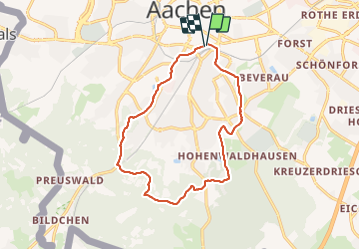
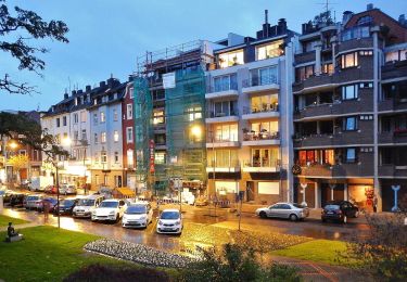
Randonnée Marche de 12,9 km à découvrir à Rhénanie-du-Nord-Westphalie, Région urbaine d'Aix-la-Chapelle, Aix-la-Chapelle. Cette randonnée est proposée par Greg813.

Description

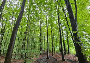
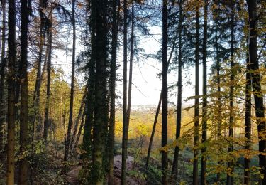
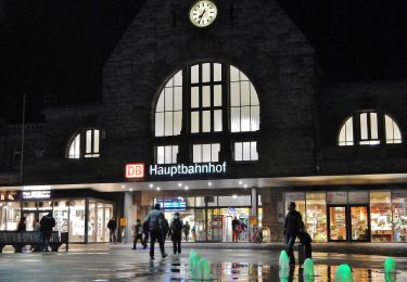
Randonnée avec Mettons le Monde en Marche dans les bois au sud d'Aix-la-Chapelle (Aachen) depuis la gare.

Pour d'autres photos, voir le site de l'association :
https://mmm-rando.org/aachen-allemagne-2021/

Profil altimétrique

Localisation

Pays :
Allemagne
Région :
Rhénanie-du-Nord-Westphalie
Département/Province :
Région urbaine d'Aix-la-Chapelle
Commune :
Aix-la-Chapelle
Localité :
Aachen-Mitte
Départ:(UTM)
294893 ; 5628087 (32U) N.

Randonnées à proximité

Randonnée Marche Aix-la-Chapelle - Aix-la-Chapelle  - Photo
Marche
GUIDE
mumu.larandonneuse

Marche

Facile
(1)
Aix-la-Chapelle, Rhénanie-du-Nord-Westphalie, Région urbaine d'Aix-la-Chapelle, Allemagne
11,4 km | 15,4 km-effort
3h 30min
Oui
Randonnée Marche Aix-la-Chapelle - Aix-la-Chapelle  - Photo
Marche
GUIDE
mumu.larandonneuse

Marche

Facile
(1)
Aix-la-Chapelle, Rhénanie-du-Nord-Westphalie, Région urbaine d'Aix-la-Chapelle, Allemagne
11,1 km | 13,4 km-effort
3h 2min
Oui
Randonnée Marche La Calamine - 20200730 - Les 3 Bornes 7.3 Km - Photo
Marche
GUIDE
pierreh01

Marche

Difficile
(1)
La Calamine, Wallonie, Liège, Belgique
7,4 km | 10,4 km-effort
1h 50min
Oui
Randonnée Marche La Calamine - Venn Trilogie (1er étape) - Photo
Marche
Godasses et Grosses Pattes

Marche

Moyen
(1)
La Calamine, Wallonie, Liège, Belgique
25 km | 30 km-effort
5h 0min
Non
Randonnée Marche La Calamine - Trois,Bornes  -  Vaals - Photo
Marche
GUIDE
mumu.larandonneuse

Marche

Moyen
La Calamine, Wallonie, Liège, Belgique
12,4 km | 16,1 km-effort
3h 9min
Oui
Randonnée Marche Aix-la-Chapelle - Aix-la-Chapelle (Rando & marché de Noël 🎅🎄) - Photo
Marche
GUIDE
mumu.larandonneuse

Marche

Facile
(1)
Aix-la-Chapelle, Rhénanie-du-Nord-Westphalie, Région urbaine d'Aix-la-Chapelle, Allemagne
10,7 km | 13,2 km-effort
3h 0min
Oui
Randonnée A pied Aix-la-Chapelle - Rundweg um Eilendorf - Photo
A pied
PRO

A pied

Facile
Aix-la-Chapelle, Rhénanie-du-Nord-Westphalie, Région urbaine d'Aix-la-Chapelle, Allemagne
12,6 km | 14,4 km-effort
3h 16min
Oui
Randonnée A pied Aix-la-Chapelle - GrenzRouten: Verbindungsweg Aachen Hbf - Köpfchen - Photo
A pied
PRO

A pied

Facile
Aix-la-Chapelle, Rhénanie-du-Nord-Westphalie, Région urbaine d'Aix-la-Chapelle, Allemagne
4,1 km | 5 km-effort
1h 8min
Non
Randonnée A pied Aix-la-Chapelle - GrenzRouten: Verbindungsweg Aachen Hbf - Entenpfuhl - Photo
A pied
PRO

A pied

Facile
Aix-la-Chapelle, Rhénanie-du-Nord-Westphalie, Région urbaine d'Aix-la-Chapelle, Allemagne
5,1 km | 6,7 km-effort
1h 31min
Non


Fermer
Mes abonnements