![](/images/other/stat-length.png)
![Randonnée A pied Évry-Grégy-sur-Yerre - J 55 Evry les Châteaux, le prieuré de Vernelle - Photo](https://media.geolcdn.com/t/1900/400/ext.pjpeg?maxdim=2&url=https%3A%2F%2Fstatic1.geolcdn.com%2Fsiteimages%2Fupload%2Ffiles%2F1545311037marcheuse_200dpi.jpg)
J 55 Evry les Châteaux, le prieuré de Vernelle
Les 1000 pattes
Club randonnées SERVON
![Longueur](/images/other/stat-length.png)
Longueur
10,8 km
![Altitude max](https://static1.geolcdn.com/siteimages/upload/files/1508320355ic_sort_altitude_max_24dp.png)
Altitude max
94 m
![Dénivelé positif](https://static1.geolcdn.com/siteimages/upload/files/1508320355ic_sort_den_pos_24dp.png)
Dénivelé positif
138 m
![Km-Effort](/images/other/stat-length.png)
Km-Effort
12,6 km
![Altitude min](https://static1.geolcdn.com/siteimages/upload/files/1508320355ic_sort_altitude_min_24dp.png)
Altitude min
52 m
![Dénivelé négatif](https://static1.geolcdn.com/siteimages/upload/files/1508320355ic_sort_den_neg_24dp.png)
Dénivelé négatif
138 m
![Boucle](https://static1.geolcdn.com/siteimages/upload/files/16400158638029165_repeat_loop_refresh_sync_direction_icon.png)
Boucle
Oui
Date de création :
2021-12-07 15:49:15.826
Dernière modification :
2024-11-27 08:43:42.605
![A pied](https://static1.geolcdn.com/sitytour/trail-icons/100.png)
2h51
Difficulté : Moyen
![Scannez ce code QR pour ouvrir la randonnée dans l'application SityTrail](https://capi.geolives.com/qq0zvz2zws4bq2lad0pu/sitytour/trails/3021122/qr.png?size=200)
Application GPS de randonnée GRATUITE
À propos
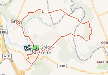
Randonnée A pied de 10,8 km à découvrir à Île-de-France, Seine-et-Marne, Évry-Grégy-sur-Yerre. Cette randonnée est proposée par Les 1000 pattes.
Description
Parking cimetière à Evry-Grégy-sur-Yerres angle Allée du château/ Rue Madeleine Boisset
Trajet Servon-->Parking (10km: 10mn)
Localisation
Pays :
France
Région :
Île-de-France
Département/Province :
Seine-et-Marne
Commune :
Évry-Grégy-sur-Yerre
Localité :
Évry-les-Châteaux
Départ:(Dec)
Départ:(UTM)
472789 ; 5389085 (31U) N.
Commentaires
Randonnées à proximité
![Randonnée Marche Brie-Comte-Robert - brie comte robert - Photo](https://media.geolcdn.com/t/375/260/ext.jpg?maxdim=2&url=https%3A%2F%2Fservices.sitytrail.com%2FGeolivesWS%2FDownloadMedia.ashx%3FTrailID%3D172162%26Media%3D20130130123759.jpeg)
![Marche Marche](https://static1.geolcdn.com/sitytour/trail-icons/101.png)
brie comte robert
Marche
Facile
(2)
Brie-Comte-Robert,
Île-de-France,
Seine-et-Marne,
France
![](/images/other/stat-length.png)
16,7 km | 18,8 km-effort
4h 21min
![](https://static1.geolcdn.com/siteimages/upload/files/16400158638029165_repeat_loop_refresh_sync_direction_icon.png)
Oui
![Randonnée Marche Évry-Grégy-sur-Yerre - J 55 miguelmillepattes Evry Grégy sur Yerres - Prieuré de Vernelle - Photo](https://media.geolcdn.com/t/375/260/838bff98-2775-4bd0-83b3-89163c602221.jpg&format=jpg&maxdim=2)
![Marche Marche](https://static1.geolcdn.com/sitytour/trail-icons/101.png)
J 55 miguelmillepattes Evry Grégy sur Yerres - Prieuré de Vernelle
Marche
Moyen
(2)
Évry-Grégy-sur-Yerre,
Île-de-France,
Seine-et-Marne,
France
![](/images/other/stat-length.png)
11,9 km | 13,6 km-effort
3h 5min
![](https://static1.geolcdn.com/siteimages/upload/files/16400158638029165_repeat_loop_refresh_sync_direction_icon.png)
Oui
![Randonnée Marche Coubert - JC 27 Coubert, Solers cimetière allemand, Prieuré de Vernelle - Photo](https://media.geolcdn.com/t/375/260/b6b52968-ca6b-4031-862f-615df2d504ec.jpg&format=jpg&maxdim=2)
![Marche Marche](https://static1.geolcdn.com/sitytour/trail-icons/101.png)
JC 27 Coubert, Solers cimetière allemand, Prieuré de Vernelle
Marche
Difficile
(1)
Coubert,
Île-de-France,
Seine-et-Marne,
France
![](/images/other/stat-length.png)
20 km | 23 km-effort
5h 11min
![](https://static1.geolcdn.com/siteimages/upload/files/16400158638029165_repeat_loop_refresh_sync_direction_icon.png)
Oui
![Randonnée Marche Brie-Comte-Robert - AdxBCR13PlaineChvry - Photo](https://media.geolcdn.com/t/375/260/ext.jpg?maxdim=2&url=https%3A%2F%2Fstatic1.geolcdn.com%2Fsiteimages%2Fupload%2Ffiles%2F1553511878bg_sport_marche.png)
![Marche Marche](https://static1.geolcdn.com/sitytour/trail-icons/101.png)
AdxBCR13PlaineChvry
Marche
Difficile
(1)
Brie-Comte-Robert,
Île-de-France,
Seine-et-Marne,
France
![](/images/other/stat-length.png)
13,4 km | 14,1 km-effort
3h 11min
![](https://static1.geolcdn.com/siteimages/upload/files/16400158638029165_repeat_loop_refresh_sync_direction_icon.png)
Oui
![Randonnée Marche Brie-Comte-Robert - AdxBCR13Santenybis - Photo](https://media.geolcdn.com/t/375/260/ext.jpg?maxdim=2&url=https%3A%2F%2Fstatic1.geolcdn.com%2Fsiteimages%2Fupload%2Ffiles%2F1553511878bg_sport_marche.png)
![Marche Marche](https://static1.geolcdn.com/sitytour/trail-icons/101.png)
AdxBCR13Santenybis
Marche
Difficile
(1)
Brie-Comte-Robert,
Île-de-France,
Seine-et-Marne,
France
![](/images/other/stat-length.png)
13,6 km | 14,9 km-effort
3h 23min
![](https://static1.geolcdn.com/siteimages/upload/files/16400158638029165_repeat_loop_refresh_sync_direction_icon.png)
Oui
![Randonnée Marche Coubert - J 66 Coubert et Suisnes - Photo](https://media.geolcdn.com/t/375/260/ext.jpg?maxdim=2&url=https%3A%2F%2Fstatic1.geolcdn.com%2Fsiteimages%2Fupload%2Ffiles%2F1553511878bg_sport_marche.png)
![Marche Marche](https://static1.geolcdn.com/sitytour/trail-icons/101.png)
J 66 Coubert et Suisnes
Marche
Difficile
(3)
Coubert,
Île-de-France,
Seine-et-Marne,
France
![](/images/other/stat-length.png)
11,5 km | 12,7 km-effort
2h 53min
![](https://static1.geolcdn.com/siteimages/upload/files/16400158638029165_repeat_loop_refresh_sync_direction_icon.png)
Oui
![Randonnée A pied Combs-la-Ville - L 35 Combs la Ville Hameau de la Sansonne - Photo](https://media.geolcdn.com/t/375/260/ext.jpg?maxdim=2&url=https%3A%2F%2Fstatic1.geolcdn.com%2Fsiteimages%2Fupload%2Ffiles%2F1545311037marcheuse_200dpi.jpg)
![A pied A pied](https://static1.geolcdn.com/sitytour/trail-icons/100.png)
L 35 Combs la Ville Hameau de la Sansonne
A pied
Facile
(4)
Combs-la-Ville,
Île-de-France,
Seine-et-Marne,
France
![](/images/other/stat-length.png)
7,7 km | 8,3 km-effort
1h 52min
![](https://static1.geolcdn.com/siteimages/upload/files/16400158638029165_repeat_loop_refresh_sync_direction_icon.png)
Oui
![Randonnée A pied Moissy-Cramayel - L 46 Moissy Cramayel, butte d'Egrenay - Photo](https://media.geolcdn.com/t/375/260/ext.jpg?maxdim=2&url=https%3A%2F%2Fstatic1.geolcdn.com%2Fsiteimages%2Fupload%2Ffiles%2F1545311037marcheuse_200dpi.jpg)
![A pied A pied](https://static1.geolcdn.com/sitytour/trail-icons/100.png)
L 46 Moissy Cramayel, butte d'Egrenay
A pied
Très facile
(2)
Moissy-Cramayel,
Île-de-France,
Seine-et-Marne,
France
![](/images/other/stat-length.png)
6,9 km | 7,4 km-effort
1h 40min
![](https://static1.geolcdn.com/siteimages/upload/files/16400158638029165_repeat_loop_refresh_sync_direction_icon.png)
Oui
![Randonnée V.T.T. Brie-Comte-Robert - Chemin des Roses et Vallée De l'Yerre - Photo](https://media.geolcdn.com/t/375/260/ext.jpg?maxdim=2&url=https%3A%2F%2Fstatic1.geolcdn.com%2Fsiteimages%2Fupload%2Ffiles%2F1524743154velo.jpg)
![V.T.T. V.T.T.](https://static1.geolcdn.com/sitytour/trail-icons/202.png)
Chemin des Roses et Vallée De l'Yerre
V.T.T.
Moyen
(2)
Brie-Comte-Robert,
Île-de-France,
Seine-et-Marne,
France
![](/images/other/stat-length.png)
39 km | 43 km-effort
2h 50min
![](https://static1.geolcdn.com/siteimages/upload/files/16400158638029165_repeat_loop_refresh_sync_direction_icon.png)
Oui