Randonnée A pied Mazamet - LABRESPY - LAC DES MONTAGNES - Photo

LABRESPY - LAC DES MONTAGNES

 randopat-tarn sud
randopat-tarn sud

Utilisateur

© OpenStreetMap contributors
Longueur
Longueur
9,2 km
Altitude max
Altitude max
706 m
Dénivelé positif
Dénivelé positif
238 m
Km-Effort
Km-Effort  
12,4 km
Altitude min
Altitude min
506 m
Dénivelé négatif
Dénivelé négatif
241 m
Boucle
Boucle
Oui
Date de création :
2021-12-05 10:28:20.507
Dernière modification :
2021-12-05 10:38:01.347

(0 Avis)

A pied
A pied
2h49
Difficulté : Facile

Scannez ce code QR pour ouvrir la randonnée dans l'application SityTrail

Application GPS de randonnée GRATUITE

Logo SityTrail SityTrail

IGN / Instituts géographiques

Télécharger SityTrail sur l'App Store Télécharger SityTrail sur Google Play

Logo SityTrail SityTrail World

Le monde est à vous

Télécharger SityTrail sur l'App Store Télécharger SityTrail sur Google Play Télécharger SityTrail sur Huawei AppGallery

À propos

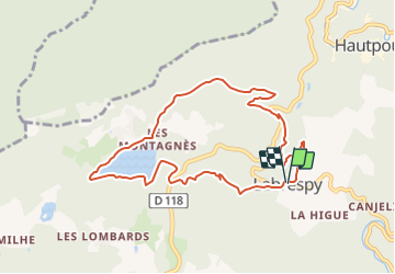
Randonnée A pied de 9,2 km à découvrir à Occitanie, Tarn, Mazamet. Cette randonnée est proposée par randopat-tarn sud.

Description

En partant de Labrespy direction (Nord Ouest) vers le lac des Montagnès, en passant par Les Blancs, La Surlauze, La Martinarié, en faisant le tour du lac des Montagnès, en redescendant plein Est par Les Estrabots. Belles fenêtres sur la Montagne Noire.

Profil altimétrique

Localisation

Pays :
France
Région :
Occitanie
Département/Province :
Tarn
Commune :
Mazamet
Localité :
Unknown
Départ:(UTM)
448698 ; 4812107 (31T) N.

Randonnées à proximité

Randonnée Marche Mazamet - Mazamet - Hautpoul - Photo
Marche
tracegps

Marche

Difficile
(1)
Mazamet, Occitanie, Tarn, France
17,4 km | 29 km-effort
6h 30min
Oui
Randonnée Marche Mazamet - Maeamet la passerelle - Photo
Marche
ombrabella

Marche

Moyen
Mazamet, Occitanie, Tarn, France
4,5 km | 8,6 km-effort
1h 32min
Oui
Randonnée Marche Mazamet - Passerelle de Mazamet et village médiéval d'Hautpoul - Photo
Marche
Dominique48

Marche

Difficile
Mazamet, Occitanie, Tarn, France
3,2 km | 6,9 km-effort
1h 41min
Oui
Randonnée V.T.T. Aussillon - Montagne Noire -  Les Montagnès  - Photo
V.T.T.
guillaumepdm

V.T.T.

Difficile
(1)
Aussillon, Occitanie, Tarn, France
29 km | 41 km-effort
2h 49min
Oui
Randonnée Marche Mazamet - depuis HAUPOULet  en 2 boucles - Photo
Marche
chrisgps

Marche

Très facile
Mazamet, Occitanie, Tarn, France
14,2 km | 23 km-effort
6h 6min
Oui
Randonnée Marche Mazamet - Labrespy, Hautpoul, St-Pierre des Plots - Photo
Marche
Jean-Phi81

Marche

Moyen
(1)
Mazamet, Occitanie, Tarn, France
9 km | 13,8 km-effort
3h 1min
Oui
Randonnée Marche Mazamet - Labrespy - la Croix de Prat - Photo
Marche
Jean-Phi81

Marche

Moyen
(1)
Mazamet, Occitanie, Tarn, France
13,8 km | 21 km-effort
4h 35min
Oui
Randonnée Marche Aiguefonde - AIGUEFONDE Les Fermes - Photo
Marche
miqueljp

Marche

Moyen
(1)
Aiguefonde, Occitanie, Tarn, France
11,6 km | 17,9 km-effort
3h 50min
Oui
Randonnée Marche Mazamet - Tours et détours dans le Sambrès - Roquerlan - Photo
Marche
tracegps

Marche

Moyen
Mazamet, Occitanie, Tarn, France
20 km | 29 km-effort
6h 0min
Oui


Fermer
Mes abonnements