![](/images/other/stat-length.png)
![Randonnée Marche Liverdy-en-Brie - J 72 les gués de la Marsange et Liverdy en Brie - Photo](https://media.geolcdn.com/t/1900/400/ext.pjpeg?maxdim=2&url=https%3A%2F%2Fstatic1.geolcdn.com%2Fsiteimages%2Fupload%2Ffiles%2F1553511878bg_sport_marche.png)
J 72 les gués de la Marsange et Liverdy en Brie
Les 1000 pattes
Club randonnées SERVON
![Longueur](/images/other/stat-length.png)
Longueur
14,3 km
![Altitude max](https://static1.geolcdn.com/siteimages/upload/files/1508320355ic_sort_altitude_max_24dp.png)
Altitude max
108 m
![Dénivelé positif](https://static1.geolcdn.com/siteimages/upload/files/1508320355ic_sort_den_pos_24dp.png)
Dénivelé positif
86 m
![Km-Effort](/images/other/stat-length.png)
Km-Effort
15,5 km
![Altitude min](https://static1.geolcdn.com/siteimages/upload/files/1508320355ic_sort_altitude_min_24dp.png)
Altitude min
71 m
![Dénivelé négatif](https://static1.geolcdn.com/siteimages/upload/files/1508320355ic_sort_den_neg_24dp.png)
Dénivelé négatif
87 m
![Boucle](https://static1.geolcdn.com/siteimages/upload/files/16400158638029165_repeat_loop_refresh_sync_direction_icon.png)
Boucle
Oui
Date de création :
2021-12-01 12:24:25.155
Dernière modification :
2021-12-01 12:28:51.118
![Marche](https://static1.geolcdn.com/sitytour/trail-icons/101.png)
3h30
Difficulté : Moyen
![Scannez ce code QR pour ouvrir la randonnée dans l'application SityTrail](https://capi.geolives.com/qq0zvz2zws4bq2lad0pu/sitytour/trails/3016742/qr.png?size=200)
Application GPS de randonnée GRATUITE
À propos
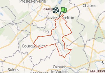
Randonnée Marche de 14,3 km à découvrir à Île-de-France, Seine-et-Marne, Liverdy-en-Brie. Cette randonnée est proposée par Les 1000 pattes.
Description
Parking Rue Gustave Delage à Liverdy en Brie
Trajet Servon-->Liverdy en Brie (27km: 25mn)
Localisation
Pays :
France
Région :
Île-de-France
Département/Province :
Seine-et-Marne
Commune :
Liverdy-en-Brie
Localité :
Unknown
Départ:(Dec)
Départ:(UTM)
483413 ; 5394157 (31U) N.
Commentaires
Randonnées à proximité
![Randonnée A pied Presles-en-Brie - L 11 Presles-en-Brie - Photo](https://media.geolcdn.com/t/375/260/18f4f276-45b3-4df3-8ac7-bc080c65ab8d.jpg&format=jpg&maxdim=2)
![A pied A pied](https://static1.geolcdn.com/sitytour/trail-icons/100.png)
L 11 Presles-en-Brie
A pied
Très facile
(2)
Presles-en-Brie,
Île-de-France,
Seine-et-Marne,
France
![](/images/other/stat-length.png)
5,6 km | 6,4 km-effort
1h 26min
![](https://static1.geolcdn.com/siteimages/upload/files/16400158638029165_repeat_loop_refresh_sync_direction_icon.png)
Oui
![Randonnée Marche Chaumes-en-Brie - Boucle 19 km Chaumes en Brie - Photo](https://media.geolcdn.com/t/375/260/70ebe8e4-d694-4301-a1eb-7913d93071d0.jpg&format=jpg&maxdim=2)
![Marche Marche](https://static1.geolcdn.com/sitytour/trail-icons/101.png)
Boucle 19 km Chaumes en Brie
Marche
Facile
Chaumes-en-Brie,
Île-de-France,
Seine-et-Marne,
France
![](/images/other/stat-length.png)
19,4 km | 22 km-effort
5h 1min
![](https://static1.geolcdn.com/siteimages/upload/files/16400158638029165_repeat_loop_refresh_sync_direction_icon.png)
Oui
![Randonnée Marche Tournan-en-Brie - TOURNAN > VERNEUIL 22 KM - Photo](https://media.geolcdn.com/t/375/260/ext.jpg?maxdim=2&url=https%3A%2F%2Fstatic1.geolcdn.com%2Fsiteimages%2Fupload%2Ffiles%2F1553511878bg_sport_marche.png)
![Marche Marche](https://static1.geolcdn.com/sitytour/trail-icons/101.png)
TOURNAN > VERNEUIL 22 KM
Marche
Très facile
(1)
Tournan-en-Brie,
Île-de-France,
Seine-et-Marne,
France
![](/images/other/stat-length.png)
22 km | 25 km-effort
5h 35min
![](https://static1.geolcdn.com/siteimages/upload/files/16400158638029165_repeat_loop_refresh_sync_direction_icon.png)
Non
![Randonnée Marche Ozouer-le-Voulgis - autour? - Photo](https://media.geolcdn.com/t/375/260/97cebebb-fdbb-4139-b072-b3a92a132a3a.jpg&format=jpg&maxdim=2)
![Marche Marche](https://static1.geolcdn.com/sitytour/trail-icons/101.png)
autour?
Marche
Très facile
Ozouer-le-Voulgis,
Île-de-France,
Seine-et-Marne,
France
![](/images/other/stat-length.png)
6,3 km | 7,1 km-effort
3h 16min
![](https://static1.geolcdn.com/siteimages/upload/files/16400158638029165_repeat_loop_refresh_sync_direction_icon.png)
Non
![Randonnée Marche Chaumes-en-Brie - Autour de CHAUMES en BRIE - Photo](https://media.geolcdn.com/t/375/260/27579921-6113-4a63-a05a-e95624baef28.jpg&format=jpg&maxdim=2)
![Marche Marche](https://static1.geolcdn.com/sitytour/trail-icons/101.png)
Autour de CHAUMES en BRIE
Marche
Moyen
Chaumes-en-Brie,
Île-de-France,
Seine-et-Marne,
France
![](/images/other/stat-length.png)
21 km | 23 km-effort
5h 0min
![](https://static1.geolcdn.com/siteimages/upload/files/16400158638029165_repeat_loop_refresh_sync_direction_icon.png)
Oui
![Randonnée Marche Tournan-en-Brie - TEM77 2017 - Photo](https://media.geolcdn.com/t/375/260/ext.jpg?maxdim=2&url=https%3A%2F%2Fstatic1.geolcdn.com%2Fsiteimages%2Fupload%2Ffiles%2F1553511878bg_sport_marche.png)
![Marche Marche](https://static1.geolcdn.com/sitytour/trail-icons/101.png)
TEM77 2017
Marche
Très facile
(1)
Tournan-en-Brie,
Île-de-France,
Seine-et-Marne,
France
![](/images/other/stat-length.png)
77 km | 85 km-effort
13h 40min
![](https://static1.geolcdn.com/siteimages/upload/files/16400158638029165_repeat_loop_refresh_sync_direction_icon.png)
Oui
![Randonnée Marche Chaumes-en-Brie - Chaumes'Yerres - Photo](https://media.geolcdn.com/t/375/260/ext.jpg?maxdim=2&url=https%3A%2F%2Fservices.sitytrail.com%2FGeolivesWS%2FDownloadMedia.ashx%3FTrailID%3D415743%26Media%3Dccd14579-d4e0-494c-9820-adb9307e2c19.jpg)
![Marche Marche](https://static1.geolcdn.com/sitytour/trail-icons/101.png)
Chaumes'Yerres
Marche
Moyen
Chaumes-en-Brie,
Île-de-France,
Seine-et-Marne,
France
![](/images/other/stat-length.png)
23 km | 26 km-effort
5h 35min
![](https://static1.geolcdn.com/siteimages/upload/files/16400158638029165_repeat_loop_refresh_sync_direction_icon.png)
Oui
![Randonnée Marche Chaumes-en-Brie - Chaumes en Brie, circuit n° 1 - Photo](https://media.geolcdn.com/t/375/260/ext.jpg?maxdim=2&url=https%3A%2F%2Fservices.sitytrail.com%2FGeolivesWS%2FDownloadMedia.ashx%3FTrailID%3D111792%26Media%3D8333_4.jpg)
![Marche Marche](https://static1.geolcdn.com/sitytour/trail-icons/101.png)
Chaumes en Brie, circuit n° 1
Marche
Moyen
(1)
Chaumes-en-Brie,
Île-de-France,
Seine-et-Marne,
France
![](/images/other/stat-length.png)
10,7 km | 12,2 km-effort
2h 40min
![](https://static1.geolcdn.com/siteimages/upload/files/16400158638029165_repeat_loop_refresh_sync_direction_icon.png)
Oui
![Randonnée Marche Chaumes-en-Brie - ouest de forest 2011-11-27 17h41m03 - Photo](https://media.geolcdn.com/t/375/260/ext.jpg?maxdim=2&url=https%3A%2F%2Fstatic1.geolcdn.com%2Fsiteimages%2Fupload%2Ffiles%2F1553511878bg_sport_marche.png)
![Marche Marche](https://static1.geolcdn.com/sitytour/trail-icons/101.png)
ouest de forest 2011-11-27 17h41m03
Marche
Moyen
(1)
Chaumes-en-Brie,
Île-de-France,
Seine-et-Marne,
France
![](/images/other/stat-length.png)
6 km | 6,6 km-effort
1h 57min
![](https://static1.geolcdn.com/siteimages/upload/files/16400158638029165_repeat_loop_refresh_sync_direction_icon.png)
Non