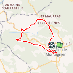
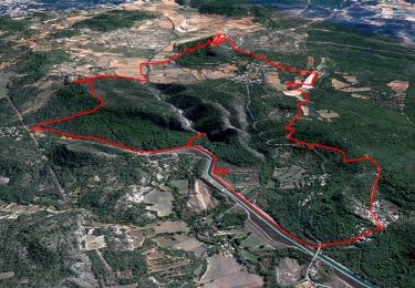
![](/images/other/stat-length.png)
![Randonnée Marche Saint-Julien - St Jean le Montagnier - Photo](https://media.geolcdn.com/t/1900/400/ext.pjpeg?maxdim=2&url=https%3A%2F%2Fservices.sitytrail.com%2FGeolivesWS%2FDownloadMedia.ashx%3FTrailID%3D301575%26Media%3Dcac9191e-7283-45a2-a363-f1872978defb.jpg)
St Jean le Montagnier
Loumo29
Utilisateur
![Longueur](/images/other/stat-length.png)
![Altitude max](https://static1.geolcdn.com/siteimages/upload/files/1508320355ic_sort_altitude_max_24dp.png)
![Dénivelé positif](https://static1.geolcdn.com/siteimages/upload/files/1508320355ic_sort_den_pos_24dp.png)
![Km-Effort](/images/other/stat-length.png)
![Altitude min](https://static1.geolcdn.com/siteimages/upload/files/1508320355ic_sort_altitude_min_24dp.png)
![Dénivelé négatif](https://static1.geolcdn.com/siteimages/upload/files/1508320355ic_sort_den_neg_24dp.png)
![Boucle](https://static1.geolcdn.com/siteimages/upload/files/16400158638029165_repeat_loop_refresh_sync_direction_icon.png)
![Marche](https://static1.geolcdn.com/sitytour/trail-icons/101.png)
3h52
Difficulté : Moyen
![Scannez ce code QR pour ouvrir la randonnée dans l'application SityTrail](https://capi.geolives.com/qq0zvz2zws4bq2lad0pu/sitytour/trails/301575/qr.png?size=200)
Application GPS de randonnée GRATUITE
À propos
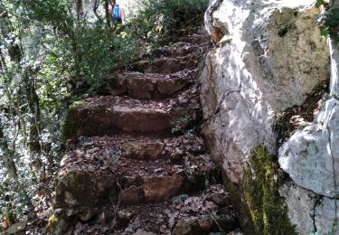
Randonnée Marche de 13,8 km à découvrir à Provence-Alpes-Côte d'Azur, Var, Saint-Julien. Cette randonnée est proposée par Loumo29.
Description
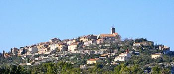
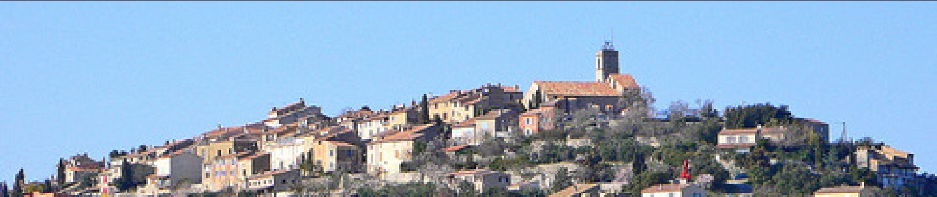
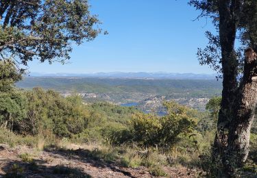
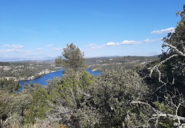
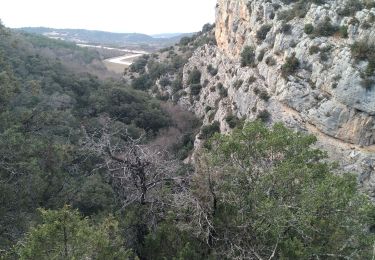
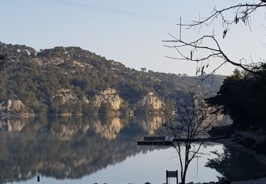
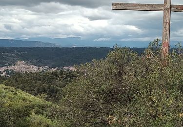
La commune de Saint-Julien est située au nord-ouest du département du Var, sur la rive gauche du Verdon, à la hauteur des basses gorges et du lac d'Esparron. Le village, perché sur une butte isolée, domine les plans de Haute-Provence, succession de plateaux rocheux, couverts d'une maigre végétation arbustive, sur lesquels de place en place une petite agglomération forme le centre d'une surface bien cultivée où dominent quelques céréales, la vigne, la lavande et les oliviers.
La commune de Saint-Julien est incluse dans l'aire du Parc naturel régional du Verdon.
(source Wikipédia).
Localisation
Commentaires
Randonnées à proximité
![Randonnée Marche Saint-Julien - Autour de Saint Julien le Montagnier - Photo](https://media.geolcdn.com/t/375/260/3ef2484b-75f1-4519-bd6c-2cfbe3cc63d2.jpg&format=jpg&maxdim=2)
![Marche Marche](https://static1.geolcdn.com/sitytour/trail-icons/101.png)
Marche
![](/images/other/stat-length.png)
![](https://static1.geolcdn.com/siteimages/upload/files/16400158638029165_repeat_loop_refresh_sync_direction_icon.png)
![Randonnée Marche Saint-Julien - 2022-11-11 Balcon de Saint Julien au lac d'Esparon - Photo](https://media.geolcdn.com/t/375/260/62e038c3-e228-4ae0-bf51-fb91477c57ba.jpg&format=jpg&maxdim=2)
![Marche Marche](https://static1.geolcdn.com/sitytour/trail-icons/101.png)
Marche
![](/images/other/stat-length.png)
![](https://static1.geolcdn.com/siteimages/upload/files/16400158638029165_repeat_loop_refresh_sync_direction_icon.png)
![Randonnée Marche Esparron-de-Verdon - VERDON: SENTIER VERS ESPARRON de Verdon. - Photo](https://media.geolcdn.com/t/375/260/a272c2b1-8b59-4b0a-a41f-cf1731d4a7fb.jpg&format=jpg&maxdim=2)
![Marche Marche](https://static1.geolcdn.com/sitytour/trail-icons/101.png)
Marche
![](/images/other/stat-length.png)
![](https://static1.geolcdn.com/siteimages/upload/files/16400158638029165_repeat_loop_refresh_sync_direction_icon.png)
![Randonnée Marche Saint-Julien - St Julien - Grotte de Malavasse - Photo](https://media.geolcdn.com/t/375/260/c80d5ad6-4e61-45a1-a28d-af60e80bae63.jpg&format=jpg&maxdim=2)
![Marche Marche](https://static1.geolcdn.com/sitytour/trail-icons/101.png)
Marche
![](/images/other/stat-length.png)
![](https://static1.geolcdn.com/siteimages/upload/files/16400158638029165_repeat_loop_refresh_sync_direction_icon.png)
![Randonnée Marche Saint-Julien - Le drapeau depuis Les Hugous+ petite incursion dans Malavalas - Photo](https://media.geolcdn.com/t/375/260/160938d6-595e-43a0-98b5-2872a94eaff0.jpg&format=jpg&maxdim=2)
![Marche Marche](https://static1.geolcdn.com/sitytour/trail-icons/101.png)
Marche
![](/images/other/stat-length.png)
![](https://static1.geolcdn.com/siteimages/upload/files/16400158638029165_repeat_loop_refresh_sync_direction_icon.png)
![Randonnée Marche Saint-Julien - 1Départ le long du lac D'Esparon - Photo](https://media.geolcdn.com/t/375/260/106fec4d-8e51-4d1a-8009-d7ac3698da33.jpg&format=jpg&maxdim=2)
![Marche Marche](https://static1.geolcdn.com/sitytour/trail-icons/101.png)
Marche
![](/images/other/stat-length.png)
![](https://static1.geolcdn.com/siteimages/upload/files/16400158638029165_repeat_loop_refresh_sync_direction_icon.png)
![Randonnée Marche Saint-Julien - Boucle du lac (grand format) - Photo](https://media.geolcdn.com/t/375/260/5b9184b9-97bd-4481-b73b-e8b04d6c21b1.jpg&format=jpg&maxdim=2)
![Marche Marche](https://static1.geolcdn.com/sitytour/trail-icons/101.png)
Marche
![](/images/other/stat-length.png)
![](https://static1.geolcdn.com/siteimages/upload/files/16400158638029165_repeat_loop_refresh_sync_direction_icon.png)
![Randonnée Marche Saint-Julien - Les Maurras Les Garduères rduaires - Photo](https://media.geolcdn.com/t/375/260/fa0cec8d-445d-4df0-b0f1-f8a00cb080be.jpg&format=jpg&maxdim=2)
![Marche Marche](https://static1.geolcdn.com/sitytour/trail-icons/101.png)
Marche
![](/images/other/stat-length.png)
![](https://static1.geolcdn.com/siteimages/upload/files/16400158638029165_repeat_loop_refresh_sync_direction_icon.png)
![Randonnée Marche Saint-Julien - 83 Saint Julien le Montagnier - Photo](https://media.geolcdn.com/t/375/260/0ab7c78e-7671-46a1-a48a-bdbfa9a68e8a.jpg&format=jpg&maxdim=2)
![Marche Marche](https://static1.geolcdn.com/sitytour/trail-icons/101.png)
Marche
![](/images/other/stat-length.png)
![](https://static1.geolcdn.com/siteimages/upload/files/16400158638029165_repeat_loop_refresh_sync_direction_icon.png)