![](/images/other/stat-length.png)
![Randonnée Marche Échassières - Puy de juillat - Photo](https://media.geolcdn.com/t/1900/400/ext.pjpeg?maxdim=2&url=https%3A%2F%2Fstatic1.geolcdn.com%2Fsiteimages%2Fupload%2Ffiles%2F1553511878bg_sport_marche.png)
Puy de juillat
Vincent Bicard
Utilisateur
![Longueur](/images/other/stat-length.png)
Longueur
8,7 km
![Altitude max](https://static1.geolcdn.com/siteimages/upload/files/1508320355ic_sort_altitude_max_24dp.png)
Altitude max
732 m
![Dénivelé positif](https://static1.geolcdn.com/siteimages/upload/files/1508320355ic_sort_den_pos_24dp.png)
Dénivelé positif
155 m
![Km-Effort](/images/other/stat-length.png)
Km-Effort
10,8 km
![Altitude min](https://static1.geolcdn.com/siteimages/upload/files/1508320355ic_sort_altitude_min_24dp.png)
Altitude min
648 m
![Dénivelé négatif](https://static1.geolcdn.com/siteimages/upload/files/1508320355ic_sort_den_neg_24dp.png)
Dénivelé négatif
153 m
![Boucle](https://static1.geolcdn.com/siteimages/upload/files/16400158638029165_repeat_loop_refresh_sync_direction_icon.png)
Boucle
Oui
Date de création :
2021-11-28 08:30:58.0
Dernière modification :
2021-11-28 10:37:01.639
![Marche](https://static1.geolcdn.com/sitytour/trail-icons/101.png)
2h05
Difficulté : Moyen
![Scannez ce code QR pour ouvrir la randonnée dans l'application SityTrail](https://capi.geolives.com/qq0zvz2zws4bq2lad0pu/sitytour/trails/3014337/qr.png?size=200)
Application GPS de randonnée GRATUITE
À propos
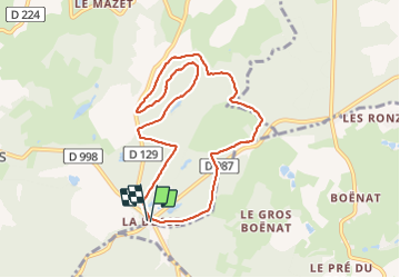
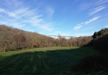
Randonnée Marche de 8,7 km à découvrir à Auvergne-Rhône-Alpes, Allier, Échassières. Cette randonnée est proposée par Vincent Bicard.
Description
Balade Dupuis de Julia sous la neige vent à 30 km à l’heure avec en moyenne 10 cm de neige par endroit 20 cm marche sans raquette
Localisation
Pays :
France
Région :
Auvergne-Rhône-Alpes
Département/Province :
Allier
Commune :
Échassières
Localité :
Unknown
Départ:(Dec)
Départ:(UTM)
497158 ; 5113713 (31T) N.
Commentaires
Randonnées à proximité
![Randonnée Marche Coutansouze - Coutansouze_Gour_Annet - Photo](https://media.geolcdn.com/t/375/260/a4cba8bf-25ad-49e2-9b7b-3fede3c87839.jpg&format=jpg&maxdim=2)
![Marche Marche](https://static1.geolcdn.com/sitytour/trail-icons/101.png)
Coutansouze_Gour_Annet
Marche
Difficile
Coutansouze,
Auvergne-Rhône-Alpes,
Allier,
France
![](/images/other/stat-length.png)
21 km | 27 km-effort
6h 30min
![](https://static1.geolcdn.com/siteimages/upload/files/16400158638029165_repeat_loop_refresh_sync_direction_icon.png)
Oui
![Randonnée V.T.T. Échassières - la bosse - Photo](https://media.geolcdn.com/t/375/260/e180551d-2c4d-40cd-badb-8d5ff667977b.jpg&format=jpg&maxdim=2)
![V.T.T. V.T.T.](https://static1.geolcdn.com/sitytour/trail-icons/202.png)
la bosse
V.T.T.
Très difficile
Échassières,
Auvergne-Rhône-Alpes,
Allier,
France
![](/images/other/stat-length.png)
32 km | 44 km-effort
4h 45min
![](https://static1.geolcdn.com/siteimages/upload/files/16400158638029165_repeat_loop_refresh_sync_direction_icon.png)
Oui
![Randonnée Marche Nades - Le sentier des minerais - Photo](https://media.geolcdn.com/t/375/260/ext.jpg?maxdim=2&url=https%3A%2F%2Fservices.sitytrail.com%2FGeolivesWS%2FDownloadMedia.ashx%3FTrailID%3D889456%26Media%3Dfix__20170715133427.jpg)
![Marche Marche](https://static1.geolcdn.com/sitytour/trail-icons/101.png)
Le sentier des minerais
Marche
Facile
Nades,
Auvergne-Rhône-Alpes,
Allier,
France
![](/images/other/stat-length.png)
15,3 km | 20 km-effort
3h 4min
![](https://static1.geolcdn.com/siteimages/upload/files/16400158638029165_repeat_loop_refresh_sync_direction_icon.png)
Oui
![Randonnée A pied Servant - Servant la cascade de Champeaux et montignat - Photo](https://media.geolcdn.com/t/375/260/ext.jpg?maxdim=2&url=https%3A%2F%2Fstatic1.geolcdn.com%2Fsiteimages%2Fupload%2Ffiles%2F1545311037marcheuse_200dpi.jpg)
![A pied A pied](https://static1.geolcdn.com/sitytour/trail-icons/100.png)
Servant la cascade de Champeaux et montignat
A pied
Moyen
Servant,
Auvergne-Rhône-Alpes,
Puy-de-Dôme,
France
![](/images/other/stat-length.png)
21 km | 28 km-effort
6h 14min
![](https://static1.geolcdn.com/siteimages/upload/files/16400158638029165_repeat_loop_refresh_sync_direction_icon.png)
Oui
![Randonnée A pied Servant - servant la cascade de champeaux - Photo](https://media.geolcdn.com/t/375/260/ext.jpg?maxdim=2&url=https%3A%2F%2Fstatic1.geolcdn.com%2Fsiteimages%2Fupload%2Ffiles%2F1545311037marcheuse_200dpi.jpg)
![A pied A pied](https://static1.geolcdn.com/sitytour/trail-icons/100.png)
servant la cascade de champeaux
A pied
Moyen
Servant,
Auvergne-Rhône-Alpes,
Puy-de-Dôme,
France
![](/images/other/stat-length.png)
21 km | 28 km-effort
6h 14min
![](https://static1.geolcdn.com/siteimages/upload/files/16400158638029165_repeat_loop_refresh_sync_direction_icon.png)
Oui
![Randonnée Marche Lalizolle - lalizolle - Photo](https://media.geolcdn.com/t/375/260/ext.jpg?maxdim=2&url=https%3A%2F%2Fstatic1.geolcdn.com%2Fsiteimages%2Fupload%2Ffiles%2F1553511878bg_sport_marche.png)
![Marche Marche](https://static1.geolcdn.com/sitytour/trail-icons/101.png)
lalizolle
Marche
Très facile
Lalizolle,
Auvergne-Rhône-Alpes,
Allier,
France
![](/images/other/stat-length.png)
9 km | 11,5 km-effort
2h 27min
![](https://static1.geolcdn.com/siteimages/upload/files/16400158638029165_repeat_loop_refresh_sync_direction_icon.png)
Oui
![Randonnée Marche Louroux-de-Bouble - Chassin a/r 12 01 2020 - Photo](https://media.geolcdn.com/t/375/260/345bc503-833c-4d31-8504-4b02898e36a2.jpg&format=jpg&maxdim=2)
![Marche Marche](https://static1.geolcdn.com/sitytour/trail-icons/101.png)
Chassin a/r 12 01 2020
Marche
Très facile
Louroux-de-Bouble,
Auvergne-Rhône-Alpes,
Allier,
France
![](/images/other/stat-length.png)
10,9 km | 14,4 km-effort
2h 46min
![](https://static1.geolcdn.com/siteimages/upload/files/16400158638029165_repeat_loop_refresh_sync_direction_icon.png)
Oui
![Randonnée Cheval Nades - 6- ChevauchéeCombrailles - Combemorel - Montmirail - Photo](https://media.geolcdn.com/t/375/260/ext.jpg?maxdim=2&url=https%3A%2F%2Fstatic1.geolcdn.com%2Fsiteimages%2Fupload%2Ffiles%2F1524743154cheval.jpg)
![Cheval Cheval](https://static1.geolcdn.com/sitytour/trail-icons/300.png)
6- ChevauchéeCombrailles - Combemorel - Montmirail
Cheval
Très facile
Nades,
Auvergne-Rhône-Alpes,
Allier,
France
![](/images/other/stat-length.png)
33 km | 43 km-effort
Inconnu
![](https://static1.geolcdn.com/siteimages/upload/files/16400158638029165_repeat_loop_refresh_sync_direction_icon.png)
Non
![Randonnée Marche Coutansouze - les Fayes a/r 17-7-2022 - Photo](https://media.geolcdn.com/t/375/260/ext.jpg?maxdim=2&url=https%3A%2F%2Fstatic1.geolcdn.com%2Fsiteimages%2Fupload%2Ffiles%2F1553511878bg_sport_marche.png)
![Marche Marche](https://static1.geolcdn.com/sitytour/trail-icons/101.png)
les Fayes a/r 17-7-2022
Marche
Difficile
Coutansouze,
Auvergne-Rhône-Alpes,
Allier,
France
![](/images/other/stat-length.png)
12,1 km | 14,8 km-effort
3h 2min
![](https://static1.geolcdn.com/siteimages/upload/files/16400158638029165_repeat_loop_refresh_sync_direction_icon.png)
Oui