![](/images/other/stat-length.png)
![Randonnée Marche Chamarande - *Chamarande Lardy - Photo](https://media.geolcdn.com/t/1900/400/ext.pjpeg?maxdim=2&url=https%3A%2F%2Fstatic1.geolcdn.com%2Fsiteimages%2Fupload%2Ffiles%2F1553511878bg_sport_marche.png)
*Chamarande Lardy
jpcccb
Utilisateur
![Longueur](/images/other/stat-length.png)
Longueur
14,4 km
![Altitude max](https://static1.geolcdn.com/siteimages/upload/files/1508320355ic_sort_altitude_max_24dp.png)
Altitude max
151 m
![Dénivelé positif](https://static1.geolcdn.com/siteimages/upload/files/1508320355ic_sort_den_pos_24dp.png)
Dénivelé positif
228 m
![Km-Effort](/images/other/stat-length.png)
Km-Effort
17,4 km
![Altitude min](https://static1.geolcdn.com/siteimages/upload/files/1508320355ic_sort_altitude_min_24dp.png)
Altitude min
58 m
![Dénivelé négatif](https://static1.geolcdn.com/siteimages/upload/files/1508320355ic_sort_den_neg_24dp.png)
Dénivelé négatif
229 m
![Boucle](https://static1.geolcdn.com/siteimages/upload/files/16400158638029165_repeat_loop_refresh_sync_direction_icon.png)
Boucle
Non
Date de création :
2021-11-26 18:35:21.328
Dernière modification :
2023-05-09 13:01:24.797
![Marche](https://static1.geolcdn.com/sitytour/trail-icons/101.png)
4h10
Difficulté : Difficile
![Scannez ce code QR pour ouvrir la randonnée dans l'application SityTrail](https://capi.geolives.com/qq0zvz2zws4bq2lad0pu/sitytour/trails/3013302/qr.png?size=200)
Application GPS de randonnée GRATUITE
À propos
Randonnée Marche de 14,4 km à découvrir à Île-de-France, Essonne, Chamarande. Cette randonnée est proposée par jpcccb.
Description
Parc de Chamarande, château, belvédère, GR 655, Gillevoisin, bois de Pernaison, pierre levée, château du Mesnil Voisin, la Juine.
Localisation
Pays :
France
Région :
Île-de-France
Département/Province :
Essonne
Commune :
Chamarande
Localité :
Unknown
Départ:(Dec)
Départ:(UTM)
442108 ; 5373768 (31U) N.
Commentaires
Randonnées à proximité
![Randonnée Marche Lardy - Lardy - Chamarande -F - Photo](https://media.geolcdn.com/t/375/260/ext.jpg?maxdim=2&url=https%3A%2F%2Fservices.sitytrail.com%2FGeolivesWS%2FDownloadMedia.ashx%3FTrailID%3D274259%26Media%3Dfix__20140504142726.jpg)
![Marche Marche](https://static1.geolcdn.com/sitytour/trail-icons/101.png)
Lardy - Chamarande -F
Marche
Moyen
(2)
Lardy,
Île-de-France,
Essonne,
France
![](/images/other/stat-length.png)
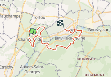
18,3 km | 22 km-effort
4h 44min
![](https://static1.geolcdn.com/siteimages/upload/files/16400158638029165_repeat_loop_refresh_sync_direction_icon.png)
Oui
![Randonnée Marche Saint-Sulpice-de-Favières - Les Pétales de Souzy - Photo](https://media.geolcdn.com/t/375/260/ext.jpg?maxdim=2&url=https%3A%2F%2Fservices.sitytrail.com%2FGeolivesWS%2FDownloadMedia.ashx%3FTrailID%3D110217%26Media%3D5477_1.jpg)
![Marche Marche](https://static1.geolcdn.com/sitytour/trail-icons/101.png)
Les Pétales de Souzy
Marche
Difficile
(1)
Saint-Sulpice-de-Favières,
Île-de-France,
Essonne,
France
![](/images/other/stat-length.png)
23 km | 29 km-effort
4h 49min
![](https://static1.geolcdn.com/siteimages/upload/files/16400158638029165_repeat_loop_refresh_sync_direction_icon.png)
Oui
![Randonnée Marche Lardy - Autour de Lardy par la Pierre levée de Janville sur Juine - Photo](https://media.geolcdn.com/t/375/260/ext.jpg?maxdim=2&url=https%3A%2F%2Fservices.sitytrail.com%2FGeolivesWS%2FDownloadMedia.ashx%3FTrailID%3D110136%26Media%3D5334_1.jpg)
![Marche Marche](https://static1.geolcdn.com/sitytour/trail-icons/101.png)
Autour de Lardy par la Pierre levée de Janville sur Juine
Marche
Difficile
(1)
Lardy,
Île-de-France,
Essonne,
France
![](/images/other/stat-length.png)
24 km | 29 km-effort
4h 49min
![](https://static1.geolcdn.com/siteimages/upload/files/16400158638029165_repeat_loop_refresh_sync_direction_icon.png)
Oui
![Randonnée A pied Auvers-Saint-Georges - Au grès de la Juine - Photo](https://media.geolcdn.com/t/375/260/ext.jpg?maxdim=2&url=https%3A%2F%2Fmedia.geolcdn.com%2Ff%2F72c017b2-4cbc-4eae-9d9f-90478ed2d91b.jpeg)
![A pied A pied](https://static1.geolcdn.com/sitytour/trail-icons/100.png)
Au grès de la Juine
A pied
Moyen
Auvers-Saint-Georges,
Île-de-France,
Essonne,
France
![](/images/other/stat-length.png)
22 km | 27 km-effort
6h 10min
![](https://static1.geolcdn.com/siteimages/upload/files/16400158638029165_repeat_loop_refresh_sync_direction_icon.png)
Non
![Randonnée Marche Étréchy - Boucle de 2 jours au départ d'Etréchy via Etampes Chalo St Mars - Photo](https://media.geolcdn.com/t/375/260/ext.jpg?maxdim=2&url=https%3A%2F%2Fstatic1.geolcdn.com%2Fsiteimages%2Fupload%2Ffiles%2F1553511878bg_sport_marche.png)
![Marche Marche](https://static1.geolcdn.com/sitytour/trail-icons/101.png)
Boucle de 2 jours au départ d'Etréchy via Etampes Chalo St Mars
Marche
Très difficile
(1)
Étréchy,
Île-de-France,
Essonne,
France
![](/images/other/stat-length.png)
42 km | 51 km-effort
11h 28min
![](https://static1.geolcdn.com/siteimages/upload/files/16400158638029165_repeat_loop_refresh_sync_direction_icon.png)
Oui
![Randonnée Marche Saint-Sulpice-de-Favières - St Sulpice - Photo](https://media.geolcdn.com/t/375/260/ext.jpg?maxdim=2&url=https%3A%2F%2Fstatic1.geolcdn.com%2Fsiteimages%2Fupload%2Ffiles%2F1553511878bg_sport_marche.png)
![Marche Marche](https://static1.geolcdn.com/sitytour/trail-icons/101.png)
St Sulpice
Marche
Moyen
(1)
Saint-Sulpice-de-Favières,
Île-de-France,
Essonne,
France
![](/images/other/stat-length.png)
8 km | 10,1 km-effort
2h 18min
![](https://static1.geolcdn.com/siteimages/upload/files/16400158638029165_repeat_loop_refresh_sync_direction_icon.png)
Oui
![Randonnée Marche Boissy-sous-Saint-Yon - Carrière de Madagascar - Photo](https://media.geolcdn.com/t/375/260/ext.jpg?maxdim=2&url=https%3A%2F%2Fstatic1.geolcdn.com%2Fsiteimages%2Fupload%2Ffiles%2F1553511878bg_sport_marche.png)
![Marche Marche](https://static1.geolcdn.com/sitytour/trail-icons/101.png)
Carrière de Madagascar
Marche
Très facile
(1)
Boissy-sous-Saint-Yon,
Île-de-France,
Essonne,
France
![](/images/other/stat-length.png)
13,2 km | 16,5 km-effort
2h 59min
![](https://static1.geolcdn.com/siteimages/upload/files/16400158638029165_repeat_loop_refresh_sync_direction_icon.png)
Oui
![Randonnée A pied Lardy - Boucle Lardy par Pascale - Photo](https://media.geolcdn.com/t/375/260/ext.jpg?maxdim=2&url=https%3A%2F%2Fmedia.geolcdn.com%2Ff%2Ffcd0ce26-70c7-4c63-8ed6-22b96bedd69d.jpg)
![A pied A pied](https://static1.geolcdn.com/sitytour/trail-icons/100.png)
Boucle Lardy par Pascale
A pied
Facile
Lardy,
Île-de-France,
Essonne,
France
![](/images/other/stat-length.png)
20 km | 25 km-effort
5h 36min
![](https://static1.geolcdn.com/siteimages/upload/files/16400158638029165_repeat_loop_refresh_sync_direction_icon.png)
Oui
![Randonnée Marche Auvers-Saint-Georges - Auvers-Saint-Georges - Photo](https://media.geolcdn.com/t/375/260/ext.jpg?maxdim=2&url=https%3A%2F%2Fmedia.geolcdn.com%2Ff%2F94651cc4-eb6a-4aac-ab8a-ddf377c2df63.jpg)
![Marche Marche](https://static1.geolcdn.com/sitytour/trail-icons/101.png)
Auvers-Saint-Georges
Marche
Moyen
Auvers-Saint-Georges,
Île-de-France,
Essonne,
France
![](/images/other/stat-length.png)
8,3 km | 10,3 km-effort
2h 20min
![](https://static1.geolcdn.com/siteimages/upload/files/16400158638029165_repeat_loop_refresh_sync_direction_icon.png)
Oui