Randonnée V.T.T. Virton - Bois de la Côte II  -  Balade_VTT_23kms - Photo

Bois de la Côte II - Balade_VTT_23kms

 Pascal L
Pascal L

Utilisateur

© OpenStreetMap contributors
Longueur
Longueur
23 km
Altitude max
Altitude max
404 m
Dénivelé positif
Dénivelé positif
348 m
Km-Effort
Km-Effort  
28 km
Altitude min
Altitude min
200 m
Dénivelé négatif
Dénivelé négatif
348 m
Boucle
Boucle
Oui
Date de création :
2021-11-23 10:52:52.359
Dernière modification :
2022-11-05 15:59:44.098

(0 Avis)

V.T.T.
V.T.T.
2h00
Difficulté : Moyen

Scannez ce code QR pour ouvrir la randonnée dans l'application SityTrail

Application GPS de randonnée GRATUITE

Logo SityTrail SityTrail

IGN / Instituts géographiques

Télécharger SityTrail sur l'App Store Télécharger SityTrail sur Google Play

Logo SityTrail SityTrail World

Le monde est à vous

Télécharger SityTrail sur l'App Store Télécharger SityTrail sur Google Play Télécharger SityTrail sur Huawei AppGallery

À propos

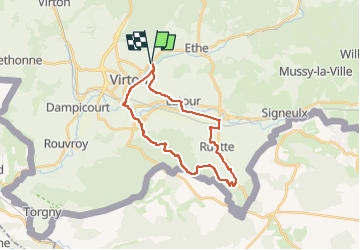
Randonnée V.T.T. de 23 km à découvrir à Wallonie, Luxembourg, Virton. Cette randonnée est proposée par Pascal L.

Description

Départ/Retour: Virton (Pierard)
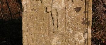
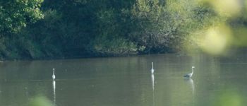
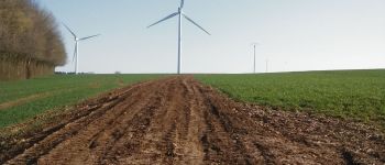
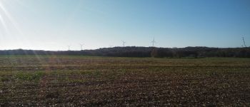
Endroits de passage : Solumont, Vieux-Virton, Saint-Mard, Bois de la Côte, l'Abîme de St-Mard, Croix Valentin, Stocfontaine, vue sur le parc d'éoliennes d'Allondrelle-la-Malmaison (France), Bois de la Côre ou de la Sente, Bois de Grandcourt, Grandcourt, Ruette, Etangs de Latour.

Vidéos:
1. https://vimeo.com/666720805   (Saint-Mard, Lat: 49,54371, Lng: 5,54342)
2. https://vimeo.com/746780539   (Parcs éoliens, Lat: 49,52641, Lng: 5,57342)
3. https://vimeo.com/746786117   (Grandcourt, Lat: 49,52090 , Lng: 5,60222 )

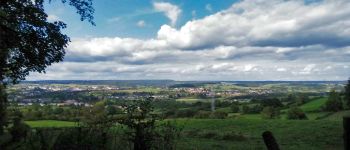
Remarque: très belle promenade avec de beaux points de vues. La difficulté majeure est la montée jusque dans le Bois de la Côte (alt. 403m).

Ref.
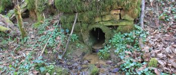
- http://biodiversite.wallonie.be/fr/6827-abime-de-saint-mard.html?IDD=335545293&IDC=2831#
- http://biodiversite.wallonie.be/fr/2201-abime-de-saint-mard.html?IDD=251660529&IDC=1881
- https://www.thewindpower.net/windfarm_fr_21688_allondrelle-la-malmaison.php
- http://jeanfrancoishusson.fr/inauguration-du-parc-eolien-d-allondrelle-la-malmaison/

(2021.11.23)

Profil altimétrique

Photos

93 photos au total. Cliquez sur une photo pour les afficher toutes dans la galerie.

Points d'intérêt

Point d'intérêt Virton - Croix Valentin - Photo
Pascal L
Point d'intérêt Virton - Les étangs de Latour - Photo
Pascal L
Point d'intérêt Virton - Sources du Bruzel - Photo
Pascal L
Point d'intérêt Saint-Pancré - Parcs éoliens des Deux Rivières (France) - Photo
Pascal L
Point d'intérêt Virton - Moulin Naisse à Virton - Photo
Pascal L
Point d'intérêt Virton - Château de Latour - Photo
Pascal L
Point d'intérêt Allondrelle-la-Malmaison - Parcs éoliens d'Allondrelle-la-Malmaison (France) - Photo
Pascal L
ALLONDRELLE-LA-MALMAISON 

Localisation

Pays :
Belgique
Région :
Wallonie
Département/Province :
Luxembourg
Commune :
Virton
Localité :
Virton
Départ:(UTM)
684238 ; 5494495 (31U) N.

Randonnées à proximité

Randonnée Marche Virton - RB-Lu-17_Ethe_via-var-1-et-2-et-3 - Photo
Marche
PRO

Marche

Très facile
(3)
Virton, Wallonie, Luxembourg, Belgique
29 km | 35 km-effort
7h 33min
Oui
Randonnée V.T.T. Virton - Autour de Ethe  -  Balade_VTT_20kms - Photo
V.T.T.
Pascal L

V.T.T.

Facile
(1)
Virton, Wallonie, Luxembourg, Belgique
21 km | 26 km-effort
1h 40min
Oui
Randonnée Marche Virton - GAUME Balade  naturelle et historique - Photo
Marche
julucasi

Marche

Très facile
(1)
Virton, Wallonie, Luxembourg, Belgique
5,2 km | 6,8 km-effort
1h 16min
Oui
Randonnée A pied Virton - La Bajocienne - Photo
A pied
GUIDE+

A pied

Facile
(1)
Virton, Wallonie, Luxembourg, Belgique
11 km | 14,5 km-effort
3h 17min
Oui
Randonnée Marche Virton - RB-Lu-17_Ethe_via-racc - Photo
Marche
PRO

Marche

Très facile
Virton, Wallonie, Luxembourg, Belgique
15,6 km | 19,3 km-effort
4h 8min
Oui
Randonnée Marche Virton - RB-Lu-17_Ethe - Photo
Marche
PRO

Marche

Très facile
Virton, Wallonie, Luxembourg, Belgique
22 km | 28 km-effort
5h 55min
Oui
Randonnée V.T.T. Virton - Autour de Tintigny  -  Balade_VTT_54Kms - Photo
V.T.T.
Pascal L

V.T.T.

Très difficile
Virton, Wallonie, Luxembourg, Belgique
54 km | 64 km-effort
4h 25min
Oui
Randonnée V.T.T. Virton - Monquintin  -  Balade_VTT_22Kms - Photo
V.T.T.
Pascal L

V.T.T.

Moyen
Virton, Wallonie, Luxembourg, Belgique
22 km | 26 km-effort
1h 48min
Oui
Randonnée V.T.T. Virton - Orval  -  Balade_VTT_50Kms - Photo
V.T.T.
Pascal L

V.T.T.

Très difficile
Virton, Wallonie, Luxembourg, Belgique
50 km | 61 km-effort
4h 15min
Non


Fermer
Mes abonnements