![](/images/other/stat-length.png)
![Randonnée Vélo Cepoy - La](https://media.geolcdn.com/t/1900/400/ext.pjpeg?maxdim=2&url=https%3A%2F%2Fstatic1.geolcdn.com%2Fsiteimages%2Fupload%2Ffiles%2F1524743154velo.jpg)
La "Forêt des M" (Partie 2)
becyclette
Utilisateur
![Longueur](/images/other/stat-length.png)
![Altitude max](https://static1.geolcdn.com/siteimages/upload/files/1508320355ic_sort_altitude_max_24dp.png)
![Dénivelé positif](https://static1.geolcdn.com/siteimages/upload/files/1508320355ic_sort_den_pos_24dp.png)
![Km-Effort](/images/other/stat-length.png)
![Altitude min](https://static1.geolcdn.com/siteimages/upload/files/1508320355ic_sort_altitude_min_24dp.png)
![Dénivelé négatif](https://static1.geolcdn.com/siteimages/upload/files/1508320355ic_sort_den_neg_24dp.png)
![Boucle](https://static1.geolcdn.com/siteimages/upload/files/16400158638029165_repeat_loop_refresh_sync_direction_icon.png)
![Vélo](https://static1.geolcdn.com/sitytour/trail-icons/200.png)
1h57
Difficulté : Moyen
![Scannez ce code QR pour ouvrir la randonnée dans l'application SityTrail](https://capi.geolives.com/qq0zvz2zws4bq2lad0pu/sitytour/trails/301021/qr.png?size=200)
Application GPS de randonnée GRATUITE
À propos
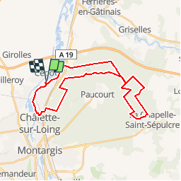
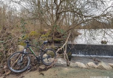
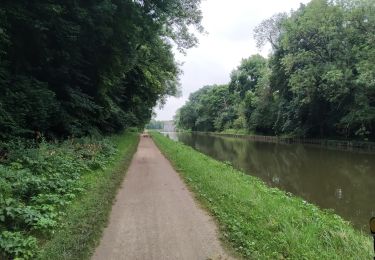
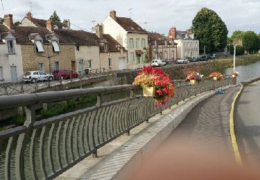
Randonnée Vélo de 30 km à découvrir à Centre-Val de Loire, Loiret, Cepoy. Cette randonnée est proposée par becyclette.
Description
Départ au bord de l'eau pour un parcours avec quelques dénivelés ou vos 5 sens vont être en effervescence. Le chant des grenouilles, le bois des essences forestières, l'odeur des sapins, la splendide vallée sèche, la saveur d'un pique nique au cœur de la nature, … tout est fait pour oublier que la civilisation n'est pas si loin ! Il est alors l'heure de regagner le lieu de départ de votre épopée, des souvenirs plein la tête et les yeux. (Temps minimum : 2h / 6H si on s'arrête à chaque point remarquable, que l'on pique nique et que l'on descend à chaque côte ! ;-) )
Localisation
Commentaires
Randonnées à proximité
![Randonnée Marche Paucourt - Foret de Paucourt 1 - Photo](https://media.geolcdn.com/t/375/260/ext.jpg?maxdim=2&url=https%3A%2F%2Fstatic1.geolcdn.com%2Fsiteimages%2Fupload%2Ffiles%2F1553511878bg_sport_marche.png)
![Marche Marche](https://static1.geolcdn.com/sitytour/trail-icons/101.png)
Marche
![](/images/other/stat-length.png)
![](https://static1.geolcdn.com/siteimages/upload/files/16400158638029165_repeat_loop_refresh_sync_direction_icon.png)
![Randonnée Marche Chalette-sur-Loing - Chalette sur Loing 45 - Photo](https://media.geolcdn.com/t/375/260/a85a4b31-fdfd-4bfa-9b85-b286a7fdd598.jpg&format=jpg&maxdim=2)
![Marche Marche](https://static1.geolcdn.com/sitytour/trail-icons/101.png)
Marche
![](/images/other/stat-length.png)
![](https://static1.geolcdn.com/siteimages/upload/files/16400158638029165_repeat_loop_refresh_sync_direction_icon.png)
![Randonnée Marche Paucourt - paucourt - Photo](https://media.geolcdn.com/t/375/260/0d5b98d1-99e8-401d-b110-67b014e8f009.jpg&format=jpg&maxdim=2)
![Marche Marche](https://static1.geolcdn.com/sitytour/trail-icons/101.png)
Marche
![](/images/other/stat-length.png)
![](https://static1.geolcdn.com/siteimages/upload/files/16400158638029165_repeat_loop_refresh_sync_direction_icon.png)
![Randonnée Marche Montargis - Montargis 45 - Photo](https://media.geolcdn.com/t/375/260/d360611b-4607-4481-af02-12b2c62acd19.jpg&format=jpg&maxdim=2)
![Marche Marche](https://static1.geolcdn.com/sitytour/trail-icons/101.png)
Marche
![](/images/other/stat-length.png)
![](https://static1.geolcdn.com/siteimages/upload/files/16400158638029165_repeat_loop_refresh_sync_direction_icon.png)
![Randonnée Marche Montargis - Montargis 45 les ponts - Photo](https://media.geolcdn.com/t/375/260/68f579d1-238c-4980-ab6a-f04ee618ad0d.jpg&format=jpg&maxdim=2)
![Marche Marche](https://static1.geolcdn.com/sitytour/trail-icons/101.png)
Marche
![](/images/other/stat-length.png)
![](https://static1.geolcdn.com/siteimages/upload/files/16400158638029165_repeat_loop_refresh_sync_direction_icon.png)
![Randonnée V.T.T. Chalette-sur-Loing - 2 eme sortie - Photo](https://media.geolcdn.com/t/375/260/4020bc2b-bcd8-4770-90bf-2988b79c9eae.jpg&format=jpg&maxdim=2)
![V.T.T. V.T.T.](https://static1.geolcdn.com/sitytour/trail-icons/202.png)
V.T.T.
![](/images/other/stat-length.png)
![](https://static1.geolcdn.com/siteimages/upload/files/16400158638029165_repeat_loop_refresh_sync_direction_icon.png)
![Randonnée Cyclotourisme Montargis - Montargis - Dammarie les Lys par EuroVélo3 - Photo](https://media.geolcdn.com/t/375/260/8185593c-e148-40f9-ada2-edf1dbd8ffa9.jpg&format=jpg&maxdim=2)
![Cyclotourisme Cyclotourisme](https://static1.geolcdn.com/sitytour/trail-icons/204.png)
Cyclotourisme
![](/images/other/stat-length.png)
![](https://static1.geolcdn.com/siteimages/upload/files/16400158638029165_repeat_loop_refresh_sync_direction_icon.png)
![Randonnée Marche Montargis - Montargis 45. tour de la ville Gi - Photo](https://media.geolcdn.com/t/375/260/e060bbb3-49c7-4182-821e-f8aec15cc535.jpg&format=jpg&maxdim=2)
![Marche Marche](https://static1.geolcdn.com/sitytour/trail-icons/101.png)
Marche
![](/images/other/stat-length.png)
![](https://static1.geolcdn.com/siteimages/upload/files/16400158638029165_repeat_loop_refresh_sync_direction_icon.png)
![Randonnée Marche Cepoy - Cepoy - Photo](https://media.geolcdn.com/t/375/260/ext.jpg?maxdim=2&url=https%3A%2F%2Fservices.sitytrail.com%2FGeolivesWS%2FDownloadMedia.ashx%3FTrailID%3D612852%26Media%3Dfix__20160811182600.jpg)
![Marche Marche](https://static1.geolcdn.com/sitytour/trail-icons/101.png)
Marche
![](/images/other/stat-length.png)
![](https://static1.geolcdn.com/siteimages/upload/files/16400158638029165_repeat_loop_refresh_sync_direction_icon.png)