![](/images/other/stat-length.png)
![Randonnée Marche Chaumont-Gistoux - #181012b - Corroy-Le-Grand et le Val d'Ocquière*** - Photo](https://media.geolcdn.com/t/1900/400/ext.pjpeg?maxdim=2&url=https%3A%2F%2Fstatic1.geolcdn.com%2Fsiteimages%2Fupload%2Ffiles%2F1553511878bg_sport_marche.png)
#181012b - Corroy-Le-Grand et le Val d'Ocquière***
Randos Ouvertes
Utilisateur
![Longueur](/images/other/stat-length.png)
![Altitude max](https://static1.geolcdn.com/siteimages/upload/files/1508320355ic_sort_altitude_max_24dp.png)
![Dénivelé positif](https://static1.geolcdn.com/siteimages/upload/files/1508320355ic_sort_den_pos_24dp.png)
![Km-Effort](/images/other/stat-length.png)
![Altitude min](https://static1.geolcdn.com/siteimages/upload/files/1508320355ic_sort_altitude_min_24dp.png)
![Dénivelé négatif](https://static1.geolcdn.com/siteimages/upload/files/1508320355ic_sort_den_neg_24dp.png)
![Boucle](https://static1.geolcdn.com/siteimages/upload/files/16400158638029165_repeat_loop_refresh_sync_direction_icon.png)
![Marche](https://static1.geolcdn.com/sitytour/trail-icons/101.png)
1h55
Difficulté : Moyen
![Scannez ce code QR pour ouvrir la randonnée dans l'application SityTrail](https://capi.geolives.com/qq0zvz2zws4bq2lad0pu/sitytour/trails/3009416/qr.png?size=200)
Application GPS de randonnée GRATUITE
À propos
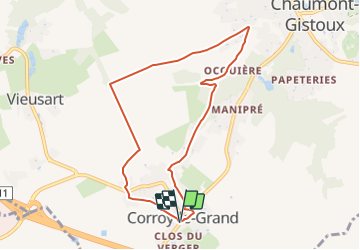
Randonnée Marche de 7,4 km à découvrir à Wallonie, Brabant wallon, Chaumont-Gistoux. Cette randonnée est proposée par Randos Ouvertes.
Description
Version "b" légèrement différente et inversée
Très belle balade facile au départ de l'église de Corroy. Bonne partie sur chemins de remembrement bétonnés à travers champs. Ce petit inconvénient est largement compensé par la beauté des paysages. Vues imprenables à 360°. Deuxième partie sur sentiers bucoliques du Val d'Ocquière et le long de la vallée du Train, le ruisseau du village. Merveilleuse dernière partie par le joli sentier du facteur.
Cet itinéraire est une alternative plus courte au circuit
https://www.routeyou.com/fr-be/route/view/6085388/itineraire-a-pied/190401-corroy-le-grand-plateau-entre-vieusart-et-gistoux-val-d-ocquiere qui fait 9,5 km (au lieu de 7).
Localisation
Commentaires
Randonnées à proximité
![Randonnée Marche Ottignies-Louvain-la-Neuve - Nuit du scoutisme - Louvain-la-Neuve - Photo](https://media.geolcdn.com/t/375/260/a66232ef-7471-42b4-b6aa-97b05d528647.jpg&format=jpg&maxdim=2)
![Marche Marche](https://static1.geolcdn.com/sitytour/trail-icons/101.png)
Marche
![](/images/other/stat-length.png)
![](https://static1.geolcdn.com/siteimages/upload/files/16400158638029165_repeat_loop_refresh_sync_direction_icon.png)
![Randonnée Marche Chaumont-Gistoux - De Dion-le Mont à Dion-le Val par la vallée du Pisselet - Photo](https://media.geolcdn.com/t/375/260/ext.jpg?maxdim=2&url=https%3A%2F%2Fstatic1.geolcdn.com%2Fsiteimages%2Fupload%2Ffiles%2F1553511878bg_sport_marche.png)
![Marche Marche](https://static1.geolcdn.com/sitytour/trail-icons/101.png)
Marche
![](/images/other/stat-length.png)
![](https://static1.geolcdn.com/siteimages/upload/files/16400158638029165_repeat_loop_refresh_sync_direction_icon.png)
![Marche Marche](https://static1.geolcdn.com/sitytour/trail-icons/101.png)
Marche
![](/images/other/stat-length.png)
![](https://static1.geolcdn.com/siteimages/upload/files/16400158638029165_repeat_loop_refresh_sync_direction_icon.png)
![Randonnée Marche Chaumont-Gistoux - BE-Chaumont-Gistoux - Vieusart - Photo](https://media.geolcdn.com/t/375/260/8d29a104-ec49-41f1-a812-8df11e0d7db1.jpg&format=jpg&maxdim=2)
![Marche Marche](https://static1.geolcdn.com/sitytour/trail-icons/101.png)
Marche
![](/images/other/stat-length.png)
![](https://static1.geolcdn.com/siteimages/upload/files/16400158638029165_repeat_loop_refresh_sync_direction_icon.png)
![Randonnée Marche Mont-Saint-Guibert - Balade à Mont-Saint-Guibert - Photo](https://media.geolcdn.com/t/375/260/ext.jpg?maxdim=2&url=https%3A%2F%2Fservices.sitytrail.com%2FGeolivesWS%2FDownloadMedia.ashx%3FTrailID%3D942864%26Media%3D4a857fe0-cf43-4eb8-b563-62b2b90d4fc2.jpg)
![Marche Marche](https://static1.geolcdn.com/sitytour/trail-icons/101.png)
Marche
![](/images/other/stat-length.png)
![](https://static1.geolcdn.com/siteimages/upload/files/16400158638029165_repeat_loop_refresh_sync_direction_icon.png)
![Randonnée Marche Ottignies-Louvain-la-Neuve - Balade dans le Bois de Lauzelle - Photo](https://media.geolcdn.com/t/375/260/ext.jpg?maxdim=2&url=https%3A%2F%2Fservices.sitytrail.com%2FGeolivesWS%2FDownloadMedia.ashx%3FTrailID%3D652718%26Media%3Dfe46824b-6e61-4100-b5d8-1f34a923c154.jpg)
![Marche Marche](https://static1.geolcdn.com/sitytour/trail-icons/101.png)
Marche
![](/images/other/stat-length.png)
![](https://static1.geolcdn.com/siteimages/upload/files/16400158638029165_repeat_loop_refresh_sync_direction_icon.png)
![Marche Marche](https://static1.geolcdn.com/sitytour/trail-icons/101.png)
Marche
![](/images/other/stat-length.png)
![](https://static1.geolcdn.com/siteimages/upload/files/16400158638029165_repeat_loop_refresh_sync_direction_icon.png)
![Marche Marche](https://static1.geolcdn.com/sitytour/trail-icons/101.png)
Marche
![](/images/other/stat-length.png)
![](https://static1.geolcdn.com/siteimages/upload/files/16400158638029165_repeat_loop_refresh_sync_direction_icon.png)
![Randonnée Marche Chaumont-Gistoux - #231016 - Corroy-Le-Grand et le Val d'Ocquière**** (inversé court) - Photo](https://media.geolcdn.com/t/375/260/b650de28-d96e-49f2-85c2-d640aecfc352.jpg&format=jpg&maxdim=2)
![Marche Marche](https://static1.geolcdn.com/sitytour/trail-icons/101.png)
Marche
![](/images/other/stat-length.png)
![](https://static1.geolcdn.com/siteimages/upload/files/16400158638029165_repeat_loop_refresh_sync_direction_icon.png)