![](/images/other/stat-length.png)
![Randonnée A pied Vatteville-la-Rue - Forêt de Brotonne Le Grand Maitre / La Vaquerie (141) - Photo](https://media.geolcdn.com/t/1900/400/ext.pjpeg?maxdim=2&url=https%3A%2F%2Fstatic1.geolcdn.com%2Fsiteimages%2Fupload%2Ffiles%2F1545311037marcheuse_200dpi.jpg)
Forêt de Brotonne Le Grand Maitre / La Vaquerie (141)
randojj
Utilisateur
![Longueur](/images/other/stat-length.png)
Longueur
11,1 km
![Altitude max](https://static1.geolcdn.com/siteimages/upload/files/1508320355ic_sort_altitude_max_24dp.png)
Altitude max
108 m
![Dénivelé positif](https://static1.geolcdn.com/siteimages/upload/files/1508320355ic_sort_den_pos_24dp.png)
Dénivelé positif
175 m
![Km-Effort](/images/other/stat-length.png)
Km-Effort
13,4 km
![Altitude min](https://static1.geolcdn.com/siteimages/upload/files/1508320355ic_sort_altitude_min_24dp.png)
Altitude min
28 m
![Dénivelé négatif](https://static1.geolcdn.com/siteimages/upload/files/1508320355ic_sort_den_neg_24dp.png)
Dénivelé négatif
174 m
![Boucle](https://static1.geolcdn.com/siteimages/upload/files/16400158638029165_repeat_loop_refresh_sync_direction_icon.png)
Boucle
Oui
Date de création :
2021-11-21 13:27:19.242
Dernière modification :
2024-09-03 08:31:20.893
![A pied](https://static1.geolcdn.com/sitytour/trail-icons/100.png)
3h03
Difficulté : Facile
![Scannez ce code QR pour ouvrir la randonnée dans l'application SityTrail](https://capi.geolives.com/qq0zvz2zws4bq2lad0pu/sitytour/trails/3008845/qr.png?size=200)
Application GPS de randonnée GRATUITE
À propos
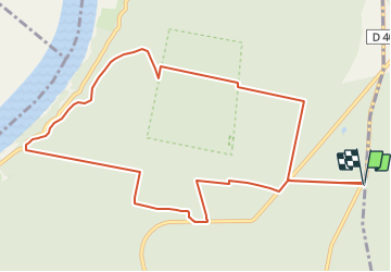
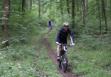
Randonnée A pied de 11,1 km à découvrir à Normandie, Seine-Maritime, Vatteville-la-Rue. Cette randonnée est proposée par randojj.
Description
Départ parking du grand Maitre au croisement de la D40 et de la route forestière de la patte d'oie (HÊTRE). Forêt Domaniale de Brotonne
Localisation
Pays :
France
Région :
Normandie
Département/Province :
Seine-Maritime
Commune :
Vatteville-la-Rue
Localité :
Unknown
Départ:(Dec)
Départ:(UTM)
333999 ; 5479379 (31U) N.
Commentaires
Randonnées à proximité
![Randonnée Marche La Haye-de-Routot - La Haye de Routot (32) - Photo](https://media.geolcdn.com/t/375/260/ext.jpg?maxdim=2&url=https%3A%2F%2Fstatic1.geolcdn.com%2Fsiteimages%2Fupload%2Ffiles%2F1553511878bg_sport_marche.png)
![Marche Marche](https://static1.geolcdn.com/sitytour/trail-icons/101.png)
La Haye de Routot (32)
Marche
Facile
(1)
La Haye-de-Routot,
Normandie,
Eure,
France
![](/images/other/stat-length.png)
11 km | 13,7 km-effort
2h 57min
![](https://static1.geolcdn.com/siteimages/upload/files/16400158638029165_repeat_loop_refresh_sync_direction_icon.png)
Oui
![Randonnée V.T.T. Vatteville-la-Rue - Foret Brotonne 2-40 - Photo](https://media.geolcdn.com/t/375/260/ext.jpg?maxdim=2&url=https%3A%2F%2Fstatic1.geolcdn.com%2Fsiteimages%2Fupload%2Ffiles%2F1524743154velo.jpg)
![V.T.T. V.T.T.](https://static1.geolcdn.com/sitytour/trail-icons/202.png)
Foret Brotonne 2-40
V.T.T.
Moyen
(1)
Vatteville-la-Rue,
Normandie,
Seine-Maritime,
France
![](/images/other/stat-length.png)
40 km | 46 km-effort
4h 0min
![](https://static1.geolcdn.com/siteimages/upload/files/16400158638029165_repeat_loop_refresh_sync_direction_icon.png)
Non
![Randonnée Cheval Vatteville-la-Rue - rando viking - Photo](https://media.geolcdn.com/t/375/260/ext.jpg?maxdim=2&url=https%3A%2F%2Fstatic1.geolcdn.com%2Fsiteimages%2Fupload%2Ffiles%2F1524743154cheval.jpg)
![Cheval Cheval](https://static1.geolcdn.com/sitytour/trail-icons/300.png)
rando viking
Cheval
Moyen
(1)
Vatteville-la-Rue,
Normandie,
Seine-Maritime,
France
![](/images/other/stat-length.png)
24 km | 30 km-effort
Inconnu
![](https://static1.geolcdn.com/siteimages/upload/files/16400158638029165_repeat_loop_refresh_sync_direction_icon.png)
Oui
![Randonnée Marche Arelaune-en-Seine - La MAILLERAYE 9 km - Photo](https://media.geolcdn.com/t/375/260/ext.jpg?maxdim=2&url=https%3A%2F%2Fservices.sitytrail.com%2FGeolivesWS%2FDownloadMedia.ashx%3FTrailID%3D1133881%26Media%3Dfix__20190411160150.jpg)
![Marche Marche](https://static1.geolcdn.com/sitytour/trail-icons/101.png)
La MAILLERAYE 9 km
Marche
Facile
Arelaune-en-Seine,
Normandie,
Seine-Maritime,
France
![](/images/other/stat-length.png)
9 km | 10 km-effort
2h 7min
![](https://static1.geolcdn.com/siteimages/upload/files/16400158638029165_repeat_loop_refresh_sync_direction_icon.png)
Oui
![Randonnée Marche La Haye-de-Routot - La Haye-de-Routot - PT - Photo](https://media.geolcdn.com/t/375/260/1e0a3e2a-9c74-413c-91e5-8494647de3b8.jpeg&format=jpg&maxdim=2)
![Marche Marche](https://static1.geolcdn.com/sitytour/trail-icons/101.png)
La Haye-de-Routot - PT
Marche
Moyen
(1)
La Haye-de-Routot,
Normandie,
Eure,
France
![](/images/other/stat-length.png)
6,8 km | 8,3 km-effort
1h 53min
![](https://static1.geolcdn.com/siteimages/upload/files/16400158638029165_repeat_loop_refresh_sync_direction_icon.png)
Oui
![Randonnée Marche La Haye-de-Routot - La Haye de Routot - Photo](https://media.geolcdn.com/t/375/260/aa7b4417-bbe1-4571-8a4e-3e25a13ebe73.jpg&format=jpg&maxdim=2)
![Marche Marche](https://static1.geolcdn.com/sitytour/trail-icons/101.png)
La Haye de Routot
Marche
Très facile
La Haye-de-Routot,
Normandie,
Eure,
France
![](/images/other/stat-length.png)
8,5 km | 10,1 km-effort
2h 39min
![](https://static1.geolcdn.com/siteimages/upload/files/16400158638029165_repeat_loop_refresh_sync_direction_icon.png)
Oui
![Randonnée Marche La Haye-de-Routot - La-Haye-de-Routot GD-11 - Photo](https://media.geolcdn.com/t/375/260/fdc96a44-3770-4702-9623-bda3fc453e57.jpg&format=jpg&maxdim=2)
![Marche Marche](https://static1.geolcdn.com/sitytour/trail-icons/101.png)
La-Haye-de-Routot GD-11
Marche
Difficile
La Haye-de-Routot,
Normandie,
Eure,
France
![](/images/other/stat-length.png)
10,6 km | 13,1 km-effort
2h 58min
![](https://static1.geolcdn.com/siteimages/upload/files/16400158638029165_repeat_loop_refresh_sync_direction_icon.png)
Oui
![Randonnée V.T.T. Arelaune-en-Seine - 1er Caux bike Ride - Vatteville la Rue - Photo](https://media.geolcdn.com/t/375/260/ext.jpg?maxdim=2&url=https%3A%2F%2Fservices.sitytrail.com%2FGeolivesWS%2FDownloadMedia.ashx%3FTrailID%3D172349%26Media%3D13681_2.jpg)
![V.T.T. V.T.T.](https://static1.geolcdn.com/sitytour/trail-icons/202.png)
1er Caux bike Ride - Vatteville la Rue
V.T.T.
Difficile
Arelaune-en-Seine,
Normandie,
Seine-Maritime,
France
![](/images/other/stat-length.png)
56 km | 68 km-effort
4h 0min
![](https://static1.geolcdn.com/siteimages/upload/files/16400158638029165_repeat_loop_refresh_sync_direction_icon.png)
Oui
![Randonnée Randonnée équestre Vatteville-la-Rue - brotonne - Photo](https://media.geolcdn.com/t/375/260/ext.jpg?maxdim=2&url=https%3A%2F%2Fstatic1.geolcdn.com%2Fsiteimages%2Fupload%2Ffiles%2F1524743154cheval.jpg)
![Randonnée équestre Randonnée équestre](https://static1.geolcdn.com/sitytour/trail-icons/301.png)
brotonne
Randonnée équestre
Moyen
Vatteville-la-Rue,
Normandie,
Seine-Maritime,
France
![](/images/other/stat-length.png)
23 km | 29 km-effort
4h 27min
![](https://static1.geolcdn.com/siteimages/upload/files/16400158638029165_repeat_loop_refresh_sync_direction_icon.png)
Non