![](/images/other/stat-length.png)
![Randonnée Marche Prads-Haute-Bléone - LA JAVIE , refuge de la Ceriege . S Pierre o n - Photo](https://media.geolcdn.com/t/1900/400/c934b9bd-78c9-4a8e-9cc4-7f90d77fa006.jpg&format=pjpeg&maxdim=2)
LA JAVIE , refuge de la Ceriege . S Pierre o n
RobinMicheline
Utilisateur GUIDE
![Longueur](/images/other/stat-length.png)
Longueur
12,3 km
![Altitude max](https://static1.geolcdn.com/siteimages/upload/files/1508320355ic_sort_altitude_max_24dp.png)
Altitude max
1176 m
![Dénivelé positif](https://static1.geolcdn.com/siteimages/upload/files/1508320355ic_sort_den_pos_24dp.png)
Dénivelé positif
615 m
![Km-Effort](/images/other/stat-length.png)
Km-Effort
21 km
![Altitude min](https://static1.geolcdn.com/siteimages/upload/files/1508320355ic_sort_altitude_min_24dp.png)
Altitude min
843 m
![Dénivelé négatif](https://static1.geolcdn.com/siteimages/upload/files/1508320355ic_sort_den_neg_24dp.png)
Dénivelé négatif
615 m
![Boucle](https://static1.geolcdn.com/siteimages/upload/files/16400158638029165_repeat_loop_refresh_sync_direction_icon.png)
Boucle
Oui
Date de création :
2021-11-19 07:06:36.4
Dernière modification :
2021-11-20 16:09:03.814
![Marche](https://static1.geolcdn.com/sitytour/trail-icons/101.png)
4h41
Difficulté : Moyen
![Scannez ce code QR pour ouvrir la randonnée dans l'application SityTrail](https://capi.geolives.com/qq0zvz2zws4bq2lad0pu/sitytour/trails/3006893/qr.png?size=200)
Application GPS de randonnée GRATUITE
À propos
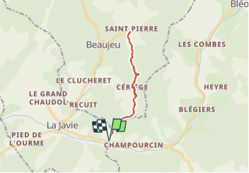
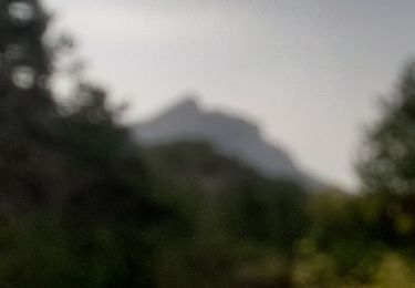
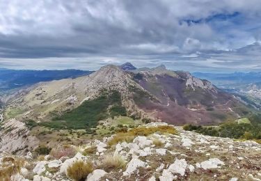
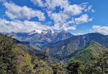
Randonnée Marche de 12,3 km à découvrir à Provence-Alpes-Côte d'Azur, Alpes-de-Haute-Provence, Prads-Haute-Bléone. Cette randonnée est proposée par RobinMicheline.
Description
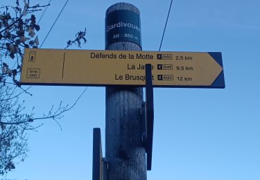
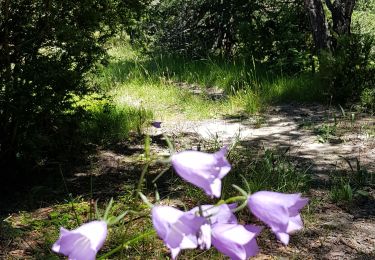
Sentiers sympa, facile , bien indiquer , refuge ouvert on peux y dormir et se chauffer
Localisation
Pays :
France
Région :
Provence-Alpes-Côte d'Azur
Département/Province :
Alpes-de-Haute-Provence
Commune :
Prads-Haute-Bléone
Localité :
Blégiers
Départ:(Dec)
Départ:(UTM)
290123 ; 4893951 (32T) N.
Commentaires
Randonnées à proximité
![Randonnée Marche Draix - DRAIX .REFUGE DE BELON .CRETE DE LA BLACHE .O L - Photo](https://media.geolcdn.com/t/375/260/e8831a04-d962-4369-8704-d88e490a9a32.jpg&format=jpg&maxdim=2)
![Marche Marche](https://static1.geolcdn.com/sitytour/trail-icons/101.png)
DRAIX .REFUGE DE BELON .CRETE DE LA BLACHE .O L
Marche
Moyen
Draix,
Provence-Alpes-Côte d'Azur,
Alpes-de-Haute-Provence,
France
![](/images/other/stat-length.png)
13,7 km | 22 km-effort
4h 7min
![](https://static1.geolcdn.com/siteimages/upload/files/16400158638029165_repeat_loop_refresh_sync_direction_icon.png)
Oui
![Randonnée Marche Prads-Haute-Bléone - Sentier MARCEL -Boucle 6.4Km) - Photo](https://media.geolcdn.com/t/375/260/ext.jpg?maxdim=2&url=https%3A%2F%2Fstatic1.geolcdn.com%2Fsiteimages%2Fupload%2Ffiles%2F1553511878bg_sport_marche.png)
![Marche Marche](https://static1.geolcdn.com/sitytour/trail-icons/101.png)
Sentier MARCEL -Boucle 6.4Km)
Marche
Moyen
(1)
Prads-Haute-Bléone,
Provence-Alpes-Côte d'Azur,
Alpes-de-Haute-Provence,
France
![](/images/other/stat-length.png)
6,2 km | 9,6 km-effort
2h 4min
![](https://static1.geolcdn.com/siteimages/upload/files/16400158638029165_repeat_loop_refresh_sync_direction_icon.png)
Oui
![Randonnée Marche Prads-Haute-Bléone - Prads-Haute-Bléone heyre chavailles 17k 950m - Photo](https://media.geolcdn.com/t/375/260/50bb1eed-d9a1-4961-a8c7-2ec2dd0405ac.jpg&format=jpg&maxdim=2)
![Marche Marche](https://static1.geolcdn.com/sitytour/trail-icons/101.png)
Prads-Haute-Bléone heyre chavailles 17k 950m
Marche
Moyen
Prads-Haute-Bléone,
Provence-Alpes-Côte d'Azur,
Alpes-de-Haute-Provence,
France
![](/images/other/stat-length.png)
15,5 km | 28 km-effort
7h 14min
![](https://static1.geolcdn.com/siteimages/upload/files/16400158638029165_repeat_loop_refresh_sync_direction_icon.png)
Oui
![Randonnée Marche Le Brusquet - LE BRUSQUET .Le tour des Blaches n - Photo](https://media.geolcdn.com/t/375/260/8f49b41b-86fe-49d3-8404-7ee7a8e8e571.jpg&format=jpg&maxdim=2)
![Marche Marche](https://static1.geolcdn.com/sitytour/trail-icons/101.png)
LE BRUSQUET .Le tour des Blaches n
Marche
Difficile
Le Brusquet,
Provence-Alpes-Côte d'Azur,
Alpes-de-Haute-Provence,
France
![](/images/other/stat-length.png)
13,4 km | 20 km-effort
3h 56min
![](https://static1.geolcdn.com/siteimages/upload/files/16400158638029165_repeat_loop_refresh_sync_direction_icon.png)
Oui
![Randonnée Marche Draix - 20210506_Draix - Tête de Chabane - Photo](https://media.geolcdn.com/t/375/260/0a858e9b-ff56-4fb8-8c1f-13fe4add2cbd.jpg&format=jpg&maxdim=2)
![Marche Marche](https://static1.geolcdn.com/sitytour/trail-icons/101.png)
20210506_Draix - Tête de Chabane
Marche
Difficile
Draix,
Provence-Alpes-Côte d'Azur,
Alpes-de-Haute-Provence,
France
![](/images/other/stat-length.png)
16,6 km | 29 km-effort
6h 40min
![](https://static1.geolcdn.com/siteimages/upload/files/16400158638029165_repeat_loop_refresh_sync_direction_icon.png)
Oui
![Randonnée Marche Beaujeu - Sommet Barre des Tremblès Via St Pierre - Photo](https://media.geolcdn.com/t/375/260/f7b3d6d8-88a1-4954-99d9-8e174bc2ae56.jpg&format=jpg&maxdim=2)
![Marche Marche](https://static1.geolcdn.com/sitytour/trail-icons/101.png)
Sommet Barre des Tremblès Via St Pierre
Marche
Très difficile
Beaujeu,
Provence-Alpes-Côte d'Azur,
Alpes-de-Haute-Provence,
France
![](/images/other/stat-length.png)
11,4 km | 19,1 km-effort
4h 20min
![](https://static1.geolcdn.com/siteimages/upload/files/16400158638029165_repeat_loop_refresh_sync_direction_icon.png)
Oui
![Randonnée Marche La Javie - 04 Près de la Javie - Chaudol/Boulard/la Bouisse - Photo](https://media.geolcdn.com/t/375/260/2973649a-4cf6-45f0-b604-4cdd48b8fc80.jpg&format=jpg&maxdim=2)
![Marche Marche](https://static1.geolcdn.com/sitytour/trail-icons/101.png)
04 Près de la Javie - Chaudol/Boulard/la Bouisse
Marche
Facile
(1)
La Javie,
Provence-Alpes-Côte d'Azur,
Alpes-de-Haute-Provence,
France
![](/images/other/stat-length.png)
14,8 km | 23 km-effort
5h 0min
![](https://static1.geolcdn.com/siteimages/upload/files/16400158638029165_repeat_loop_refresh_sync_direction_icon.png)
Oui
![Randonnée Marche La Javie - LA JAVIE le tour des vieux hameaux o - Photo](https://media.geolcdn.com/t/375/260/ext.jpg?maxdim=2&url=https%3A%2F%2Fstatic1.geolcdn.com%2Fsiteimages%2Fupload%2Ffiles%2F1553511878bg_sport_marche.png)
![Marche Marche](https://static1.geolcdn.com/sitytour/trail-icons/101.png)
LA JAVIE le tour des vieux hameaux o
Marche
Moyen
La Javie,
Provence-Alpes-Côte d'Azur,
Alpes-de-Haute-Provence,
France
![](/images/other/stat-length.png)
13,9 km | 22 km-effort
4h 31min
![](https://static1.geolcdn.com/siteimages/upload/files/16400158638029165_repeat_loop_refresh_sync_direction_icon.png)
Oui
![Randonnée Marche Prads-Haute-Bléone - Sentier Marcel 2 - Photo](https://media.geolcdn.com/t/375/260/ext.jpg?maxdim=2&url=https%3A%2F%2Fservices.sitytrail.com%2FGeolivesWS%2FDownloadMedia.ashx%3FTrailID%3D861432%26Media%3Dfix__20171112143844.jpg)
![Marche Marche](https://static1.geolcdn.com/sitytour/trail-icons/101.png)
Sentier Marcel 2
Marche
Moyen
(1)
Prads-Haute-Bléone,
Provence-Alpes-Côte d'Azur,
Alpes-de-Haute-Provence,
France
![](/images/other/stat-length.png)
11,7 km | 22 km-effort
4h 38min
![](https://static1.geolcdn.com/siteimages/upload/files/16400158638029165_repeat_loop_refresh_sync_direction_icon.png)
Oui