![](/images/other/stat-length.png)
![Randonnée Marche Montfuron - 1Montjustin - Photo](https://media.geolcdn.com/t/1900/400/5339a382-ffab-4c7a-8d94-7fa936621be8.jpg&format=pjpeg&maxdim=2)
1Montjustin
liocol
Utilisateur
![Longueur](/images/other/stat-length.png)
Longueur
9,1 km
![Altitude max](https://static1.geolcdn.com/siteimages/upload/files/1508320355ic_sort_altitude_max_24dp.png)
Altitude max
664 m
![Dénivelé positif](https://static1.geolcdn.com/siteimages/upload/files/1508320355ic_sort_den_pos_24dp.png)
Dénivelé positif
222 m
![Km-Effort](/images/other/stat-length.png)
Km-Effort
12 km
![Altitude min](https://static1.geolcdn.com/siteimages/upload/files/1508320355ic_sort_altitude_min_24dp.png)
Altitude min
545 m
![Dénivelé négatif](https://static1.geolcdn.com/siteimages/upload/files/1508320355ic_sort_den_neg_24dp.png)
Dénivelé négatif
219 m
![Boucle](https://static1.geolcdn.com/siteimages/upload/files/16400158638029165_repeat_loop_refresh_sync_direction_icon.png)
Boucle
Oui
Date de création :
2021-11-12 08:18:18.237
Dernière modification :
2021-12-14 10:31:35.202
![Marche](https://static1.geolcdn.com/sitytour/trail-icons/101.png)
2h35
Difficulté : Moyen
![Scannez ce code QR pour ouvrir la randonnée dans l'application SityTrail](https://capi.geolives.com/qq0zvz2zws4bq2lad0pu/sitytour/trails/3000360/qr.png?size=200)
Application GPS de randonnée GRATUITE
À propos
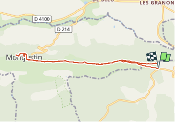
Randonnée Marche de 9,1 km à découvrir à Provence-Alpes-Côte d'Azur, Alpes-de-Haute-Provence, Montfuron. Cette randonnée est proposée par liocol.
Description
Prendre la direction de la Bastide des Jourdans, à 400 m, un petit Parking sur la droite.
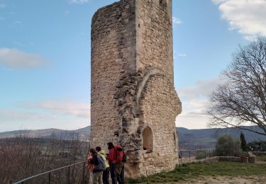
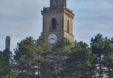
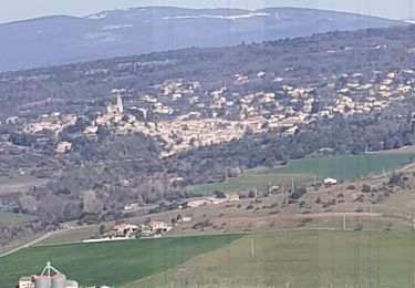
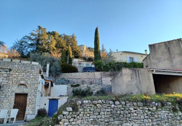
Montjustin est un très beau village, descendez vers le cimetière pour voir la tombe d'un photographe très célèbre, mort en 2004.
Localisation
Pays :
France
Région :
Provence-Alpes-Côte d'Azur
Département/Province :
Alpes-de-Haute-Provence
Commune :
Montfuron
Localité :
Unknown
Départ:(Dec)
Départ:(UTM)
715623 ; 4858265 (31T) N.
Commentaires
Randonnées à proximité
![Randonnée Marche Saint-Michel-l'Observatoire - LINCEL Moulin de l Agnelie o l - Photo](https://media.geolcdn.com/t/375/260/ext.jpg?maxdim=2&url=https%3A%2F%2Fstatic1.geolcdn.com%2Fsiteimages%2Fupload%2Ffiles%2F1553511878bg_sport_marche.png)
![Marche Marche](https://static1.geolcdn.com/sitytour/trail-icons/101.png)
LINCEL Moulin de l Agnelie o l
Marche
Facile
(1)
Saint-Michel-l'Observatoire,
Provence-Alpes-Côte d'Azur,
Alpes-de-Haute-Provence,
France
![](/images/other/stat-length.png)
13,6 km | 17,8 km-effort
6h 22min
![](https://static1.geolcdn.com/siteimages/upload/files/16400158638029165_repeat_loop_refresh_sync_direction_icon.png)
Oui
![Randonnée Marche Reillanne - reillane. carluc - Photo](https://media.geolcdn.com/t/375/260/a5a55962-1bef-44bc-99af-6edbc297f6a6.jpg&format=jpg&maxdim=2)
![Marche Marche](https://static1.geolcdn.com/sitytour/trail-icons/101.png)
reillane. carluc
Marche
Moyen
(1)
Reillanne,
Provence-Alpes-Côte d'Azur,
Alpes-de-Haute-Provence,
France
![](/images/other/stat-length.png)
10,8 km | 13,9 km-effort
3h 39min
![](https://static1.geolcdn.com/siteimages/upload/files/16400158638029165_repeat_loop_refresh_sync_direction_icon.png)
Oui
![Randonnée Marche Reillanne - 2024-03-01 Tour de Reillanne - Photo](https://media.geolcdn.com/t/375/260/71fa3e0d-dd40-4573-92ce-a7ebbe393b9d.jpg&format=jpg&maxdim=2)
![Marche Marche](https://static1.geolcdn.com/sitytour/trail-icons/101.png)
2024-03-01 Tour de Reillanne
Marche
Difficile
Reillanne,
Provence-Alpes-Côte d'Azur,
Alpes-de-Haute-Provence,
France
![](/images/other/stat-length.png)
17,9 km | 24 km-effort
5h 30min
![](https://static1.geolcdn.com/siteimages/upload/files/16400158638029165_repeat_loop_refresh_sync_direction_icon.png)
Oui
![Randonnée Marche Saint-Martin-les-Eaux - 1Domaine de Bourne - Photo](https://media.geolcdn.com/t/375/260/80f6f537-be43-4ee4-a47d-fb6f1cabac0e.jpg&format=jpg&maxdim=2)
![Marche Marche](https://static1.geolcdn.com/sitytour/trail-icons/101.png)
1Domaine de Bourne
Marche
Moyen
Saint-Martin-les-Eaux,
Provence-Alpes-Côte d'Azur,
Alpes-de-Haute-Provence,
France
![](/images/other/stat-length.png)
5,6 km | 8,3 km-effort
2h 2min
![](https://static1.geolcdn.com/siteimages/upload/files/16400158638029165_repeat_loop_refresh_sync_direction_icon.png)
Oui
![Randonnée Marche Montfuron - 1Montfuron, Villemus via la Colle et le Moulin. - Photo](https://media.geolcdn.com/t/375/260/27afe6be-9881-4392-aab5-e827ee1d3dcc.jpg&format=jpg&maxdim=2)
![Marche Marche](https://static1.geolcdn.com/sitytour/trail-icons/101.png)
1Montfuron, Villemus via la Colle et le Moulin.
Marche
Facile
Montfuron,
Provence-Alpes-Côte d'Azur,
Alpes-de-Haute-Provence,
France
![](/images/other/stat-length.png)
7,6 km | 9,9 km-effort
2h 4min
![](https://static1.geolcdn.com/siteimages/upload/files/16400158638029165_repeat_loop_refresh_sync_direction_icon.png)
Oui
![Randonnée Marche Saint-Michel-l'Observatoire - LINCEL Les Craux , S Michel 2 o - Photo](https://media.geolcdn.com/t/375/260/b292cd3d-1017-424f-9a5c-3d91ffe8bb59.jpg&format=jpg&maxdim=2)
![Marche Marche](https://static1.geolcdn.com/sitytour/trail-icons/101.png)
LINCEL Les Craux , S Michel 2 o
Marche
Facile
Saint-Michel-l'Observatoire,
Provence-Alpes-Côte d'Azur,
Alpes-de-Haute-Provence,
France
![](/images/other/stat-length.png)
11,7 km | 15,2 km-effort
3h 4min
![](https://static1.geolcdn.com/siteimages/upload/files/16400158638029165_repeat_loop_refresh_sync_direction_icon.png)
Oui
![Randonnée Marche Montfuron - 1Montfuron, le relais de Villemus - Photo](https://media.geolcdn.com/t/375/260/7ddb72e4-9bc2-4baa-9c88-e280c15c9339.jpg&format=jpg&maxdim=2)
![Marche Marche](https://static1.geolcdn.com/sitytour/trail-icons/101.png)
1Montfuron, le relais de Villemus
Marche
Moyen
(1)
Montfuron,
Provence-Alpes-Côte d'Azur,
Alpes-de-Haute-Provence,
France
![](/images/other/stat-length.png)
8 km | 11,2 km-effort
2h 9min
![](https://static1.geolcdn.com/siteimages/upload/files/16400158638029165_repeat_loop_refresh_sync_direction_icon.png)
Oui
![Randonnée Marche Saint-Michel-l'Observatoire - LINCEL. Les Craux , S Michel , l'avoir de la grande fontaine o l m s - Photo](https://media.geolcdn.com/t/375/260/2124dc70-9ed7-4aac-b4ef-5a89574157ca.jpg&format=jpg&maxdim=2)
![Marche Marche](https://static1.geolcdn.com/sitytour/trail-icons/101.png)
LINCEL. Les Craux , S Michel , l'avoir de la grande fontaine o l m s
Marche
Moyen
Saint-Michel-l'Observatoire,
Provence-Alpes-Côte d'Azur,
Alpes-de-Haute-Provence,
France
![](/images/other/stat-length.png)
13,9 km | 18,3 km-effort
4h 0min
![](https://static1.geolcdn.com/siteimages/upload/files/16400158638029165_repeat_loop_refresh_sync_direction_icon.png)
Oui
![Randonnée Marche Montfuron - Montfuron à Villemus, variante. - Photo](https://media.geolcdn.com/t/375/260/d400a1f8-5c87-481a-bdb1-b670bca05765.jpg&format=jpg&maxdim=2)
![Marche Marche](https://static1.geolcdn.com/sitytour/trail-icons/101.png)
Montfuron à Villemus, variante.
Marche
Facile
(2)
Montfuron,
Provence-Alpes-Côte d'Azur,
Alpes-de-Haute-Provence,
France
![](/images/other/stat-length.png)
7,6 km | 9,8 km-effort
2h 3min
![](https://static1.geolcdn.com/siteimages/upload/files/16400158638029165_repeat_loop_refresh_sync_direction_icon.png)
Oui