![](/images/other/stat-length.png)
![Randonnée Marche Vexin-sur-Epte - Berthenonville, Molincourt, l'allée couverte - Photo](https://media.geolcdn.com/t/1900/400/ext.pjpeg?maxdim=2&url=https%3A%2F%2Fstatic1.geolcdn.com%2Fsiteimages%2Fupload%2Ffiles%2F1553511878bg_sport_marche.png)
Berthenonville, Molincourt, l'allée couverte
Marie-Claire-mcp
Utilisateur
![Longueur](/images/other/stat-length.png)
Longueur
8,7 km
![Altitude max](https://static1.geolcdn.com/siteimages/upload/files/1508320355ic_sort_altitude_max_24dp.png)
Altitude max
136 m
![Dénivelé positif](https://static1.geolcdn.com/siteimages/upload/files/1508320355ic_sort_den_pos_24dp.png)
Dénivelé positif
162 m
![Km-Effort](/images/other/stat-length.png)
Km-Effort
10,9 km
![Altitude min](https://static1.geolcdn.com/siteimages/upload/files/1508320355ic_sort_altitude_min_24dp.png)
Altitude min
46 m
![Dénivelé négatif](https://static1.geolcdn.com/siteimages/upload/files/1508320355ic_sort_den_neg_24dp.png)
Dénivelé négatif
164 m
![Boucle](https://static1.geolcdn.com/siteimages/upload/files/16400158638029165_repeat_loop_refresh_sync_direction_icon.png)
Boucle
Oui
Date de création :
2021-11-09 12:02:35.411
Dernière modification :
2023-09-20 12:54:36.089
![Marche](https://static1.geolcdn.com/sitytour/trail-icons/101.png)
2h28
Difficulté : Moyen
![Scannez ce code QR pour ouvrir la randonnée dans l'application SityTrail](https://capi.geolives.com/qq0zvz2zws4bq2lad0pu/sitytour/trails/2997152/qr.png?size=200)
Application GPS de randonnée GRATUITE
À propos
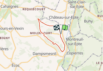
Randonnée Marche de 8,7 km à découvrir à Normandie, Eure, Vexin-sur-Epte. Cette randonnée est proposée par Marie-Claire-mcp.
Description
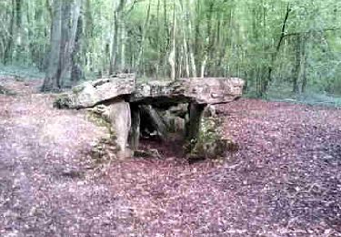
Départ centre de Berthenonville, remonter autour de l'église et continuer la route qui se transforme en chemin. suivre le PR jusqu'au Bois de Cabut puis jusqu'à Molincourt, puis direction l'allée couverte. et le petit bois d'Aulnay
Localisation
Pays :
France
Région :
Normandie
Département/Province :
Eure
Commune :
Vexin-sur-Epte
Localité :
Unknown
Départ:(Dec)
Départ:(UTM)
402338 ; 5448657 (31U) N.
Commentaires
Randonnées à proximité
![Randonnée Marche Château-sur-Epte - Château sur Epte - Berthenonville - Photo](https://media.geolcdn.com/t/375/260/ext.jpg?maxdim=2&url=https%3A%2F%2Fservices.sitytrail.com%2FGeolivesWS%2FDownloadMedia.ashx%3FTrailID%3D891370%26Media%3D28f306c4-ccd7-4e45-8d5f-378c794acdd1.jpg)
![Marche Marche](https://static1.geolcdn.com/sitytour/trail-icons/101.png)
Château sur Epte - Berthenonville
Marche
Facile
(1)
Château-sur-Epte,
Normandie,
Eure,
France
![](/images/other/stat-length.png)
7,8 km | 9,5 km-effort
2h 7min
![](https://static1.geolcdn.com/siteimages/upload/files/16400158638029165_repeat_loop_refresh_sync_direction_icon.png)
Oui
![Randonnée Marche Château-sur-Epte - Château sur Epte - Rollon Nord - Photo](https://media.geolcdn.com/t/375/260/ext.jpg?maxdim=2&url=https%3A%2F%2Fservices.sitytrail.com%2FGeolivesWS%2FDownloadMedia.ashx%3FTrailID%3D158414%26Media%3Df92478f2-a815-4319-b098-de4877cf6291.jpg)
![Marche Marche](https://static1.geolcdn.com/sitytour/trail-icons/101.png)
Château sur Epte - Rollon Nord
Marche
Facile
(1)
Château-sur-Epte,
Normandie,
Eure,
France
![](/images/other/stat-length.png)
8,4 km | 10,2 km-effort
2h 2min
![](https://static1.geolcdn.com/siteimages/upload/files/16400158638029165_repeat_loop_refresh_sync_direction_icon.png)
Oui
![Randonnée Marche Buhy - De Buchet à Magny en Vexin - Photo](https://media.geolcdn.com/t/375/260/1020b94f-166d-40ac-8266-f51a3f0e5d45.jpg&format=jpg&maxdim=2)
![Marche Marche](https://static1.geolcdn.com/sitytour/trail-icons/101.png)
De Buchet à Magny en Vexin
Marche
Moyen
Buhy,
Île-de-France,
Val-d'Oise,
France
![](/images/other/stat-length.png)
25 km | 29 km-effort
5h 3min
![](https://static1.geolcdn.com/siteimages/upload/files/16400158638029165_repeat_loop_refresh_sync_direction_icon.png)
Non
![Randonnée Marche Vexin-sur-Epte - Château sur Epte variante par pierre tournante - Photo](https://media.geolcdn.com/t/375/260/ext.jpg?maxdim=2&url=https%3A%2F%2Fstatic1.geolcdn.com%2Fsiteimages%2Fupload%2Ffiles%2F1553511878bg_sport_marche.png)
![Marche Marche](https://static1.geolcdn.com/sitytour/trail-icons/101.png)
Château sur Epte variante par pierre tournante
Marche
Facile
(1)
Vexin-sur-Epte,
Normandie,
Eure,
France
![](/images/other/stat-length.png)
9,8 km | 12,1 km-effort
2h 30min
![](https://static1.geolcdn.com/siteimages/upload/files/16400158638029165_repeat_loop_refresh_sync_direction_icon.png)
Oui
![Randonnée Marche nordique Authevernes - MN 57 Authevernes - Photo](https://media.geolcdn.com/t/375/260/ext.jpg?maxdim=2&url=https%3A%2F%2Fstatic1.geolcdn.com%2Fsiteimages%2Fupload%2Ffiles%2F1545311037marcheuse_200dpi.jpg)
![Marche nordique Marche nordique](https://static1.geolcdn.com/sitytour/trail-icons/102.png)
MN 57 Authevernes
Marche nordique
Facile
(3)
Authevernes,
Normandie,
Eure,
France
![](/images/other/stat-length.png)
8,5 km | 10,1 km-effort
1h 30min
![](https://static1.geolcdn.com/siteimages/upload/files/16400158638029165_repeat_loop_refresh_sync_direction_icon.png)
Oui
![Randonnée Marche Vexin-sur-Epte - Rando Douce 1 - Ecos - Photo](https://media.geolcdn.com/t/375/260/ext.jpg?maxdim=2&url=https%3A%2F%2Fstatic1.geolcdn.com%2Fsiteimages%2Fupload%2Ffiles%2F1553511878bg_sport_marche.png)
![Marche Marche](https://static1.geolcdn.com/sitytour/trail-icons/101.png)
Rando Douce 1 - Ecos
Marche
Facile
(1)
Vexin-sur-Epte,
Normandie,
Eure,
France
![](/images/other/stat-length.png)
6,5 km | 7,6 km-effort
1h 28min
![](https://static1.geolcdn.com/siteimages/upload/files/16400158638029165_repeat_loop_refresh_sync_direction_icon.png)
Oui
![Randonnée Marche Vexin-sur-Epte - Ecos - les trois boucles court - Photo](https://media.geolcdn.com/t/375/260/ext.jpg?maxdim=2&url=https%3A%2F%2Fstatic1.geolcdn.com%2Fsiteimages%2Fupload%2Ffiles%2F1553511878bg_sport_marche.png)
![Marche Marche](https://static1.geolcdn.com/sitytour/trail-icons/101.png)
Ecos - les trois boucles court
Marche
Facile
(2)
Vexin-sur-Epte,
Normandie,
Eure,
France
![](/images/other/stat-length.png)
11,1 km | 13,1 km-effort
2h 51min
![](https://static1.geolcdn.com/siteimages/upload/files/16400158638029165_repeat_loop_refresh_sync_direction_icon.png)
Oui
![Randonnée Marche Guerny - Gisancourt - Notre Dame du Chêne - Photo](https://media.geolcdn.com/t/375/260/ext.jpg?maxdim=2&url=https%3A%2F%2Fstatic1.geolcdn.com%2Fsiteimages%2Fupload%2Ffiles%2F1553511878bg_sport_marche.png)
![Marche Marche](https://static1.geolcdn.com/sitytour/trail-icons/101.png)
Gisancourt - Notre Dame du Chêne
Marche
Facile
(2)
Guerny,
Normandie,
Eure,
France
![](/images/other/stat-length.png)
11,6 km | 13,9 km-effort
3h 2min
![](https://static1.geolcdn.com/siteimages/upload/files/16400158638029165_repeat_loop_refresh_sync_direction_icon.png)
Oui
![Randonnée Marche Omerville - omerville et alentours - Photo](https://media.geolcdn.com/t/375/260/ext.jpg?maxdim=2&url=https%3A%2F%2Fstatic1.geolcdn.com%2Fsiteimages%2Fupload%2Ffiles%2F1553511878bg_sport_marche.png)
![Marche Marche](https://static1.geolcdn.com/sitytour/trail-icons/101.png)
omerville et alentours
Marche
Facile
(3)
Omerville,
Île-de-France,
Val-d'Oise,
France
![](/images/other/stat-length.png)
12,7 km | 16 km-effort
3h 17min
![](https://static1.geolcdn.com/siteimages/upload/files/16400158638029165_repeat_loop_refresh_sync_direction_icon.png)
Oui