![](/images/other/stat-length.png)
![Randonnée Marche Courmes - Grand tour du plateau de Saint Barnabé - Photo](https://media.geolcdn.com/t/1900/400/34a4b033-2400-4d6d-a097-311fcc2effc9.jpg&format=pjpeg&maxdim=2)
Grand tour du plateau de Saint Barnabé
jlrayon
Utilisateur
![Longueur](/images/other/stat-length.png)
![Altitude max](https://static1.geolcdn.com/siteimages/upload/files/1508320355ic_sort_altitude_max_24dp.png)
![Dénivelé positif](https://static1.geolcdn.com/siteimages/upload/files/1508320355ic_sort_den_pos_24dp.png)
![Km-Effort](/images/other/stat-length.png)
![Altitude min](https://static1.geolcdn.com/siteimages/upload/files/1508320355ic_sort_altitude_min_24dp.png)
![Dénivelé négatif](https://static1.geolcdn.com/siteimages/upload/files/1508320355ic_sort_den_neg_24dp.png)
![Boucle](https://static1.geolcdn.com/siteimages/upload/files/16400158638029165_repeat_loop_refresh_sync_direction_icon.png)
![Marche](https://static1.geolcdn.com/sitytour/trail-icons/101.png)
4h39
Difficulté : Moyen
![Scannez ce code QR pour ouvrir la randonnée dans l'application SityTrail](https://capi.geolives.com/qq0zvz2zws4bq2lad0pu/sitytour/trails/2993489/qr.png?size=200)
Application GPS de randonnée GRATUITE
À propos
Randonnée Marche de 10,8 km à découvrir à Provence-Alpes-Côte d'Azur, Alpes-Maritimes, Courmes. Cette randonnée est proposée par jlrayon.
Description
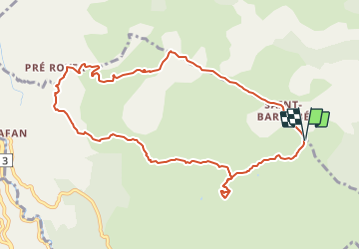
Grand tour du plateau de Saint Barnabé par la grotte de La Fumada, le Collet de Fréjus, le Pré Royer, l’Oratoire de La Baisse, visite du village pétrifié de la Sambre Brune et retour au parking.
(Trace de Rando effectuée le 5-11-2021)
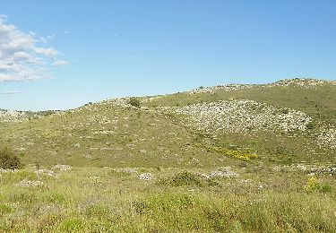
Situé à cheval sur les communes de Courmes et de Coursegoules le hameau de Saint Barnabé est entouré par un vaste plateau calcaire aride entouré de vallons verdoyant.
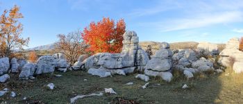
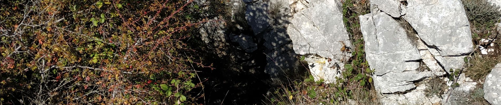
Cette rando permet d’en observer tous les aspects, les reliefs karstiques : dolines, avens, grottes, lapiaz, chaos, mais aussi des sous-bois de chênes et de pins et des garrigues, elle se termine par la visite de la Sambre Brune, un chaos ruiniforme faisant penser à village de trolls pétrifiés.
Localisation
Commentaires
Randonnées à proximité
![Randonnée Marche Tourrettes-sur-Loup - Le Puy de Naouri 1024 m, depuis Tourrettes-sur-Loup - Photo](https://media.geolcdn.com/t/375/260/ext.jpg?maxdim=2&url=https%3A%2F%2Fservices.sitytrail.com%2FGeolivesWS%2FDownloadMedia.ashx%3FTrailID%3D214858%26Media%3D15396_1.jpg)
![Marche Marche](https://static1.geolcdn.com/sitytour/trail-icons/101.png)
Marche
![](/images/other/stat-length.png)
![](https://static1.geolcdn.com/siteimages/upload/files/16400158638029165_repeat_loop_refresh_sync_direction_icon.png)
![Randonnée Marche Tourrettes-sur-Loup - Tourettes-sur loup Pic Courmettes Puys Tourettes et Naouri Trace réélle - Photo](https://media.geolcdn.com/t/375/260/f748dbe0-f767-4ec6-adb2-ccba5818c44e.jpg&format=jpg&maxdim=2)
![Marche Marche](https://static1.geolcdn.com/sitytour/trail-icons/101.png)
Marche
![](/images/other/stat-length.png)
![](https://static1.geolcdn.com/siteimages/upload/files/16400158638029165_repeat_loop_refresh_sync_direction_icon.png)
![Randonnée A pied Vence - Circuit des Blaquières - Photo](https://media.geolcdn.com/t/375/260/46014005-cf89-423b-a650-f449be44d3f6.jpeg&format=jpg&maxdim=2)
![A pied A pied](https://static1.geolcdn.com/sitytour/trail-icons/100.png)
A pied
![](/images/other/stat-length.png)
![](https://static1.geolcdn.com/siteimages/upload/files/16400158638029165_repeat_loop_refresh_sync_direction_icon.png)
![Randonnée A pied Tourrettes-sur-Loup - Circuit de Pié Martin - Photo](https://media.geolcdn.com/t/375/260/6e40e7c0-6b09-4a1a-a532-91e02b70ea94.jpeg&format=jpg&maxdim=2)
![A pied A pied](https://static1.geolcdn.com/sitytour/trail-icons/100.png)
A pied
![](/images/other/stat-length.png)
![](https://static1.geolcdn.com/siteimages/upload/files/16400158638029165_repeat_loop_refresh_sync_direction_icon.png)
![Randonnée A pied Coursegoules - Circuit du Viériou - Photo](https://media.geolcdn.com/t/375/260/033e2b9d-7778-4f86-857e-14601d59043a.jpeg&format=jpg&maxdim=2)
![A pied A pied](https://static1.geolcdn.com/sitytour/trail-icons/100.png)
A pied
![](/images/other/stat-length.png)
![](https://static1.geolcdn.com/siteimages/upload/files/16400158638029165_repeat_loop_refresh_sync_direction_icon.png)
![Randonnée A pied Gréolières - Traversée des Miroirs - Photo](https://media.geolcdn.com/t/375/260/273aae50-c65a-44a2-8836-25bdf1d17610.jpeg&format=jpg&maxdim=2)
![A pied A pied](https://static1.geolcdn.com/sitytour/trail-icons/100.png)
A pied
![](/images/other/stat-length.png)
![](https://static1.geolcdn.com/siteimages/upload/files/16400158638029165_repeat_loop_refresh_sync_direction_icon.png)
![Randonnée A pied Courmes - Plateau de Saint-Barnabé - Photo](https://media.geolcdn.com/t/375/260/e5884674-6345-4525-aa20-82da8aac2558.jpeg&format=jpg&maxdim=2)
![A pied A pied](https://static1.geolcdn.com/sitytour/trail-icons/100.png)
A pied
![](/images/other/stat-length.png)
![](https://static1.geolcdn.com/siteimages/upload/files/16400158638029165_repeat_loop_refresh_sync_direction_icon.png)
![Randonnée A pied Vence - Circuit du Malvan - Photo](https://media.geolcdn.com/t/375/260/a11b075b-d314-4d7d-9ea3-2c9f013025ba.jpeg&format=jpg&maxdim=2)
![A pied A pied](https://static1.geolcdn.com/sitytour/trail-icons/100.png)
A pied
![](/images/other/stat-length.png)
![](https://static1.geolcdn.com/siteimages/upload/files/16400158638029165_repeat_loop_refresh_sync_direction_icon.png)
![Randonnée A pied Vence - Plan des Noves - Photo](https://media.geolcdn.com/t/375/260/5bdbad17-ece4-4950-8e82-290491f5430d.jpeg&format=jpg&maxdim=2)
![A pied A pied](https://static1.geolcdn.com/sitytour/trail-icons/100.png)
A pied
![](/images/other/stat-length.png)
![](https://static1.geolcdn.com/siteimages/upload/files/16400158638029165_repeat_loop_refresh_sync_direction_icon.png)