![](/images/other/stat-length.png)
![Randonnée Marche Isola - Col de la Guercha - Photo](https://media.geolcdn.com/t/1900/400/8bbb67ab-24b8-4128-a1e0-12ad3d57f0e4.jpg&format=pjpeg&maxdim=2)
Col de la Guercha
bozo1970
Utilisateur
![Longueur](/images/other/stat-length.png)
![Altitude max](https://static1.geolcdn.com/siteimages/upload/files/1508320355ic_sort_altitude_max_24dp.png)
![Dénivelé positif](https://static1.geolcdn.com/siteimages/upload/files/1508320355ic_sort_den_pos_24dp.png)
![Km-Effort](/images/other/stat-length.png)
![Altitude min](https://static1.geolcdn.com/siteimages/upload/files/1508320355ic_sort_altitude_min_24dp.png)
![Dénivelé négatif](https://static1.geolcdn.com/siteimages/upload/files/1508320355ic_sort_den_neg_24dp.png)
![Boucle](https://static1.geolcdn.com/siteimages/upload/files/16400158638029165_repeat_loop_refresh_sync_direction_icon.png)
![Marche](https://static1.geolcdn.com/sitytour/trail-icons/101.png)
5h04
Difficulté : Très difficile
![Scannez ce code QR pour ouvrir la randonnée dans l'application SityTrail](https://capi.geolives.com/qq0zvz2zws4bq2lad0pu/sitytour/trails/2992559/qr.png?size=200)
Application GPS de randonnée GRATUITE
À propos
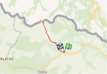
Randonnée Marche de 11,3 km à découvrir à Provence-Alpes-Côte d'Azur, Alpes-Maritimes, Isola. Cette randonnée est proposée par bozo1970.
Description
Départ de la route d’Isola 2000, balise 60
Montée par le vallon de la Guercha et le vallon de la cabane moutons
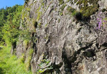
Sentier très mal tracé, mal cairné, la totale
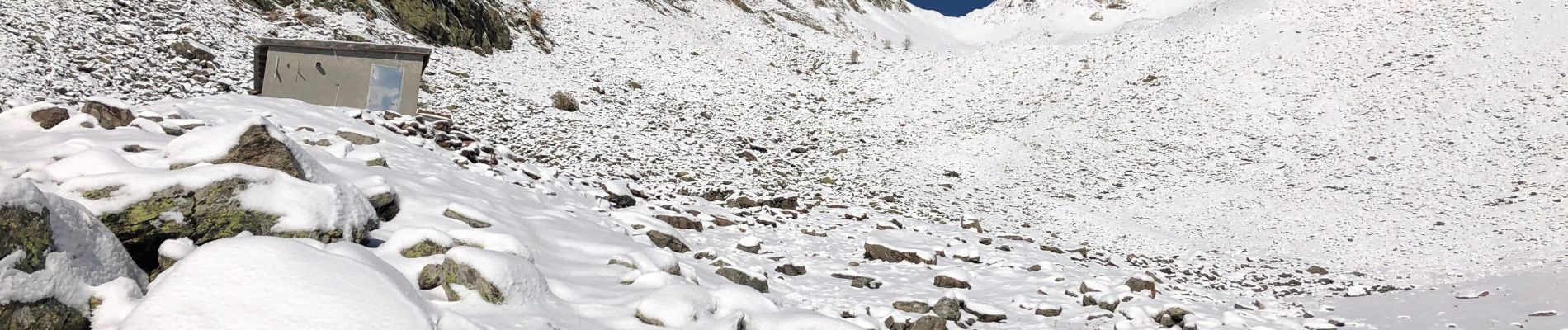
Début de la neige vers 2000m
PREMIÈRE NEIGE de la saison !!
Arrivée au col de la Guercha à 2456m d’altitude en 3h05’ avec un D de 1200m et 6km
Avec Hip-hop ( belle performance pour ses 9 ans ! )
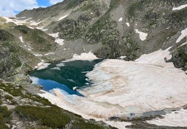
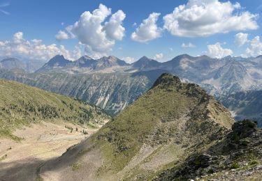
Très belle ligne de crête vers le pas du bœuf et le col de Saboulé
Localisation
Commentaires
Randonnées à proximité
![Randonnée Marche Isola - Châtaigneraie ISOLA - Photo](https://media.geolcdn.com/t/375/260/ext.jpg?maxdim=2&url=https%3A%2F%2Fservices.sitytrail.com%2FGeolivesWS%2FDownloadMedia.ashx%3FTrailID%3D470503%26Media%3D20150910120215.jpg)
![Marche Marche](https://static1.geolcdn.com/sitytour/trail-icons/101.png)
Marche
![](/images/other/stat-length.png)
![](https://static1.geolcdn.com/siteimages/upload/files/16400158638029165_repeat_loop_refresh_sync_direction_icon.png)
![Randonnée A pied Vinadio - Tour du Lausfer - Photo](https://media.geolcdn.com/t/375/260/cc4c2b4d-e173-4a84-be7d-4686c9701dd6.jpeg&format=jpg&maxdim=2)
![A pied A pied](https://static1.geolcdn.com/sitytour/trail-icons/100.png)
![Randonnée A pied Vinadio - (SI E13) Sant'Anna di Vinadio - Vinadio Frazione Strepeis - Photo](https://media.geolcdn.com/t/375/260/2964e30b-263b-42c3-aa1c-ecaafebd0df1.jpeg&format=jpg&maxdim=2)
![A pied A pied](https://static1.geolcdn.com/sitytour/trail-icons/100.png)
A pied
![](/images/other/stat-length.png)
![](https://static1.geolcdn.com/siteimages/upload/files/16400158638029165_repeat_loop_refresh_sync_direction_icon.png)
![Randonnée Marche Vinadio - Tour du Lausfer 25.8.24 - Photo](https://media.geolcdn.com/t/375/260/72863bea-5e16-4036-8653-9180a45481ca.jpg&format=jpg&maxdim=2)
![Marche Marche](https://static1.geolcdn.com/sitytour/trail-icons/101.png)
Marche
![](/images/other/stat-length.png)
![](https://static1.geolcdn.com/siteimages/upload/files/16400158638029165_repeat_loop_refresh_sync_direction_icon.png)
![Randonnée sport Vinadio - Lacs de laisser - Photo](https://media.geolcdn.com/t/375/260/3bdd8a54-1c52-4a56-821f-1ccd76f561b6.jpg&format=jpg&maxdim=2)
![Randonnée Marche Isola - Fontaine St Laurent par Collet de Léchio et Cascade de Louch Isola Village - Photo](https://media.geolcdn.com/t/375/260/db3d6713-0c9e-4c65-af5d-a138b43add5e.jpg&format=jpg&maxdim=2)
![Marche Marche](https://static1.geolcdn.com/sitytour/trail-icons/101.png)
Marche
![](/images/other/stat-length.png)
![](https://static1.geolcdn.com/siteimages/upload/files/16400158638029165_repeat_loop_refresh_sync_direction_icon.png)
![Randonnée Raquettes à neige Isola - Mont St Sauveur - Photo](https://media.geolcdn.com/t/375/260/d6eeec8b-d4a4-4556-9425-5c4c8488a001.jpg&format=jpg&maxdim=2)
![Raquettes à neige Raquettes à neige](https://static1.geolcdn.com/sitytour/trail-icons/504.png)
Raquettes à neige
![](/images/other/stat-length.png)
![](https://static1.geolcdn.com/siteimages/upload/files/16400158638029165_repeat_loop_refresh_sync_direction_icon.png)
![Randonnée Marche Isola - Lacs du Lausfer / pas de Ste Anne - Photo](https://media.geolcdn.com/t/375/260/c67485b0-6dd2-402f-93b8-4ef26648110e.jpg&format=jpg&maxdim=2)
![Marche Marche](https://static1.geolcdn.com/sitytour/trail-icons/101.png)
Marche
![](/images/other/stat-length.png)
![](https://static1.geolcdn.com/siteimages/upload/files/16400158638029165_repeat_loop_refresh_sync_direction_icon.png)
![Randonnée Marche Isola - Cîme de Sistron - Photo](https://media.geolcdn.com/t/375/260/8eb5e432-ee61-4397-8d76-907421cf758f.jpg&format=jpg&maxdim=2)
![Marche Marche](https://static1.geolcdn.com/sitytour/trail-icons/101.png)
Marche
![](/images/other/stat-length.png)
![](https://static1.geolcdn.com/siteimages/upload/files/16400158638029165_repeat_loop_refresh_sync_direction_icon.png)