![](/images/other/stat-length.png)
![Randonnée Marche Beauvoir-sur-Mer - Le_bocage_et_le_marais - Photo](https://media.geolcdn.com/t/1900/400/ext.pjpeg?maxdim=2&url=https%3A%2F%2Fstatic1.geolcdn.com%2Fsiteimages%2Fupload%2Ffiles%2F1553511878bg_sport_marche.png)
Le_bocage_et_le_marais
neoroll44
Utilisateur
![Longueur](/images/other/stat-length.png)
Longueur
8,6 km
![Altitude max](https://static1.geolcdn.com/siteimages/upload/files/1508320355ic_sort_altitude_max_24dp.png)
Altitude max
28 m
![Dénivelé positif](https://static1.geolcdn.com/siteimages/upload/files/1508320355ic_sort_den_pos_24dp.png)
Dénivelé positif
45 m
![Km-Effort](/images/other/stat-length.png)
Km-Effort
9,2 km
![Altitude min](https://static1.geolcdn.com/siteimages/upload/files/1508320355ic_sort_altitude_min_24dp.png)
Altitude min
0 m
![Dénivelé négatif](https://static1.geolcdn.com/siteimages/upload/files/1508320355ic_sort_den_neg_24dp.png)
Dénivelé négatif
45 m
![Boucle](https://static1.geolcdn.com/siteimages/upload/files/16400158638029165_repeat_loop_refresh_sync_direction_icon.png)
Boucle
Oui
Date de création :
2021-11-04 13:41:54.635
Dernière modification :
2021-11-14 17:13:09.895
![Marche](https://static1.geolcdn.com/sitytour/trail-icons/101.png)
2h05
Difficulté : Moyen
![Scannez ce code QR pour ouvrir la randonnée dans l'application SityTrail](https://capi.geolives.com/qq0zvz2zws4bq2lad0pu/sitytour/trails/2992288/qr.png?size=200)
Application GPS de randonnée GRATUITE
À propos
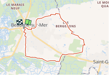
Randonnée Marche de 8,6 km à découvrir à Pays de la Loire, Vendée, Beauvoir-sur-Mer. Cette randonnée est proposée par neoroll44.
Description
Ce circuit vous projette au cœur de Beauvoir sur Mer. Découvrez ces maisons typiques à la toiture très basse. Lors de votre passage dans la Grande Rue, vous rencontrerez ces maisons rappelant "les bourrines".
Localisation
Pays :
France
Région :
Pays de la Loire
Département/Province :
Vendée
Commune :
Beauvoir-sur-Mer
Localité :
Unknown
Départ:(Dec)
Départ:(UTM)
572778 ; 5196201 (30T) N.
Commentaires
Randonnées à proximité
![Randonnée Marche Saint-Urbain - Sentier du Taizan Saint-Urbain - Photo](https://media.geolcdn.com/t/375/260/3d26bfb6-cd8d-4529-8195-c2d16fc49b2b.jpg&format=jpg&maxdim=2)
![Marche Marche](https://static1.geolcdn.com/sitytour/trail-icons/101.png)
Sentier du Taizan Saint-Urbain
Marche
Facile
Saint-Urbain,
Pays de la Loire,
Vendée,
France
![](/images/other/stat-length.png)
7,7 km | 8,2 km-effort
2h 0min
![](https://static1.geolcdn.com/siteimages/upload/files/16400158638029165_repeat_loop_refresh_sync_direction_icon.png)
Oui
![Randonnée Marche Bouin - Port du Bec - Port des Champs AR - Photo](https://media.geolcdn.com/t/375/260/ext.jpg?maxdim=2&url=https%3A%2F%2Fservices.sitytrail.com%2FGeolivesWS%2FDownloadMedia.ashx%3FTrailID%3D626244%26Media%3Dfix__20160904181646.jpg)
![Marche Marche](https://static1.geolcdn.com/sitytour/trail-icons/101.png)
Port du Bec - Port des Champs AR
Marche
Facile
Bouin,
Pays de la Loire,
Vendée,
France
![](/images/other/stat-length.png)
9,9 km | 10,3 km-effort
2h 16min
![](https://static1.geolcdn.com/siteimages/upload/files/16400158638029165_repeat_loop_refresh_sync_direction_icon.png)
Oui
![Randonnée A pied Saint-Gervais - La Chapelle de Bordevert - Photo](https://media.geolcdn.com/t/375/260/9dce997f-3364-44a9-a30e-41426994afa3.jpeg&format=jpg&maxdim=2)
![A pied A pied](https://static1.geolcdn.com/sitytour/trail-icons/100.png)
La Chapelle de Bordevert
A pied
Facile
Saint-Gervais,
Pays de la Loire,
Vendée,
France
![](/images/other/stat-length.png)
10 km | 11 km-effort
2h 29min
![](https://static1.geolcdn.com/siteimages/upload/files/16400158638029165_repeat_loop_refresh_sync_direction_icon.png)
Oui
![Randonnée Marche Saint-Gervais - St-Gervais - Photo](https://media.geolcdn.com/t/375/260/d290bc18-67e8-4e8a-943d-f33d4504b91d.jpg&format=jpg&maxdim=2)
![Marche Marche](https://static1.geolcdn.com/sitytour/trail-icons/101.png)
St-Gervais
Marche
Moyen
Saint-Gervais,
Pays de la Loire,
Vendée,
France
![](/images/other/stat-length.png)
14 km | 15,2 km-effort
3h 30min
![](https://static1.geolcdn.com/siteimages/upload/files/16400158638029165_repeat_loop_refresh_sync_direction_icon.png)
Oui
![Randonnée Course à pied La Barre-de-Monts - Pays de Jade La Barre de Mont Bourgneuf en Retz - Photo](https://media.geolcdn.com/t/375/260/ext.jpg?maxdim=2&url=https%3A%2F%2Fservices.sitytrail.com%2FGeolivesWS%2FDownloadMedia.ashx%3FTrailID%3D101027%26Media%3D520_1.jpg)
![Course à pied Course à pied](https://static1.geolcdn.com/sitytour/trail-icons/103.png)
Pays de Jade La Barre de Mont Bourgneuf en Retz
Course à pied
Très difficile
La Barre-de-Monts,
Pays de la Loire,
Vendée,
France
![](/images/other/stat-length.png)
32 km | 33 km-effort
3h 10min
![](https://static1.geolcdn.com/siteimages/upload/files/16400158638029165_repeat_loop_refresh_sync_direction_icon.png)
Non
![Randonnée V.T.T. La Barre-de-Monts - Pays de Jade La Barre de Mont Bourgneuf en Retz - Photo](https://media.geolcdn.com/t/375/260/ext.jpg?maxdim=2&url=https%3A%2F%2Fservices.sitytrail.com%2FGeolivesWS%2FDownloadMedia.ashx%3FTrailID%3D101026%26Media%3D520_1.jpg)
![V.T.T. V.T.T.](https://static1.geolcdn.com/sitytour/trail-icons/202.png)
Pays de Jade La Barre de Mont Bourgneuf en Retz
V.T.T.
Moyen
(1)
La Barre-de-Monts,
Pays de la Loire,
Vendée,
France
![](/images/other/stat-length.png)
32 km | 33 km-effort
2h 0min
![](https://static1.geolcdn.com/siteimages/upload/files/16400158638029165_repeat_loop_refresh_sync_direction_icon.png)
Non
![Randonnée Marche La Barre-de-Monts - Pays de Jade La Barre de Mont Bourgneuf en Retz - Photo](https://media.geolcdn.com/t/375/260/ext.jpg?maxdim=2&url=https%3A%2F%2Fservices.sitytrail.com%2FGeolivesWS%2FDownloadMedia.ashx%3FTrailID%3D101025%26Media%3D520_1.jpg)
![Marche Marche](https://static1.geolcdn.com/sitytour/trail-icons/101.png)
Pays de Jade La Barre de Mont Bourgneuf en Retz
Marche
Difficile
La Barre-de-Monts,
Pays de la Loire,
Vendée,
France
![](/images/other/stat-length.png)
32 km | 33 km-effort
6h 10min
![](https://static1.geolcdn.com/siteimages/upload/files/16400158638029165_repeat_loop_refresh_sync_direction_icon.png)
Non
![Randonnée Cyclotourisme Beauvoir-sur-Mer - Beauvoir - St Hilaire 53 km - Photo](https://media.geolcdn.com/t/375/260/ext.jpg?maxdim=2&url=https%3A%2F%2Fstatic1.geolcdn.com%2Fsiteimages%2Fupload%2Ffiles%2F1524743154velo.jpg)
![Cyclotourisme Cyclotourisme](https://static1.geolcdn.com/sitytour/trail-icons/204.png)
Beauvoir - St Hilaire 53 km
Cyclotourisme
Très difficile
Beauvoir-sur-Mer,
Pays de la Loire,
Vendée,
France
![](/images/other/stat-length.png)
53 km | 57 km-effort
4h 30min
![](https://static1.geolcdn.com/siteimages/upload/files/16400158638029165_repeat_loop_refresh_sync_direction_icon.png)
Non
![Randonnée A pied Saint-Gervais - La Rive du Marais - Photo](https://media.geolcdn.com/t/375/260/ext.jpg?maxdim=2&url=https%3A%2F%2Fstatic1.geolcdn.com%2Fsiteimages%2Fupload%2Ffiles%2F1545311037marcheuse_200dpi.jpg)
![A pied A pied](https://static1.geolcdn.com/sitytour/trail-icons/100.png)
La Rive du Marais
A pied
Facile
Saint-Gervais,
Pays de la Loire,
Vendée,
France
![](/images/other/stat-length.png)
12,3 km | 13,3 km-effort
3h 0min
![](https://static1.geolcdn.com/siteimages/upload/files/16400158638029165_repeat_loop_refresh_sync_direction_icon.png)
Oui