![](/images/other/stat-length.png)
![Randonnée Marche Bouillon - Dohan Boucle Sud - Photo](https://media.geolcdn.com/t/1900/400/ext.pjpeg?maxdim=2&url=https%3A%2F%2Fstatic1.geolcdn.com%2Fsiteimages%2Fupload%2Ffiles%2F1553511878bg_sport_marche.png)
Dohan Boucle Sud
thomarche
Utilisateur
![Longueur](/images/other/stat-length.png)
Longueur
12,2 km
![Altitude max](https://static1.geolcdn.com/siteimages/upload/files/1508320355ic_sort_altitude_max_24dp.png)
Altitude max
426 m
![Dénivelé positif](https://static1.geolcdn.com/siteimages/upload/files/1508320355ic_sort_den_pos_24dp.png)
Dénivelé positif
283 m
![Km-Effort](/images/other/stat-length.png)
Km-Effort
15,9 km
![Altitude min](https://static1.geolcdn.com/siteimages/upload/files/1508320355ic_sort_altitude_min_24dp.png)
Altitude min
228 m
![Dénivelé négatif](https://static1.geolcdn.com/siteimages/upload/files/1508320355ic_sort_den_neg_24dp.png)
Dénivelé négatif
283 m
![Boucle](https://static1.geolcdn.com/siteimages/upload/files/16400158638029165_repeat_loop_refresh_sync_direction_icon.png)
Boucle
Oui
Date de création :
2021-11-03 09:00:49.0
Dernière modification :
2021-11-03 12:56:55.365
![Marche](https://static1.geolcdn.com/sitytour/trail-icons/101.png)
3h21
Difficulté : Moyen
![Scannez ce code QR pour ouvrir la randonnée dans l'application SityTrail](https://capi.geolives.com/qq0zvz2zws4bq2lad0pu/sitytour/trails/2991546/qr.png?size=200)
Application GPS de randonnée GRATUITE
À propos
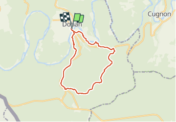
Randonnée Marche de 12,2 km à découvrir à Wallonie, Luxembourg, Bouillon. Cette randonnée est proposée par thomarche.
Description
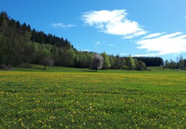
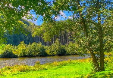
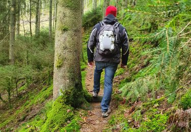
Belle boucle au sud de Dohan principalement e forêt. Points de vue sur la Semois: Roche de Dampiré et un second plus haut. Faites sous une pluie continue donc un peu raccourcie (cabane à pique nique au bord d’une petite route à pile 4km)
Localisation
Pays :
Belgique
Région :
Wallonie
Département/Province :
Luxembourg
Commune :
Bouillon
Localité :
Unknown
Départ:(Dec)
Départ:(UTM)
654156 ; 5518034 (31U) N.
Commentaires
Randonnées à proximité
![Randonnée Autre activité Bertrix - BX08 - Photo](https://media.geolcdn.com/t/375/260/ext.jpg?maxdim=2&url=https%3A%2F%2Fstatic1.geolcdn.com%2Fsiteimages%2Fupload%2Ffiles%2F1545311037marcheuse_200dpi.jpg)
![Autre activité Autre activité](https://static1.geolcdn.com/sitytour/trail-icons/900.png)
BX08
Autre activité
Très facile
(9)
Bertrix,
Wallonie,
Luxembourg,
Belgique
![](/images/other/stat-length.png)
7,3 km | 10 km-effort
2h 30min
![](https://static1.geolcdn.com/siteimages/upload/files/16400158638029165_repeat_loop_refresh_sync_direction_icon.png)
Oui
![Randonnée Marche Bouillon - GR16 SEMOIS 1 : Dohan - Photo](https://media.geolcdn.com/t/375/260/5a72d435-6e63-4e10-8243-a0a93e161c94.jpg&format=jpg&maxdim=2)
![Marche Marche](https://static1.geolcdn.com/sitytour/trail-icons/101.png)
GR16 SEMOIS 1 : Dohan
Marche
Facile
(1)
Bouillon,
Wallonie,
Luxembourg,
Belgique
![](/images/other/stat-length.png)
6,7 km | 8,3 km-effort
1h 19min
![](https://static1.geolcdn.com/siteimages/upload/files/16400158638029165_repeat_loop_refresh_sync_direction_icon.png)
Oui
![Randonnée Autre activité Bertrix - BX18 - Photo](https://media.geolcdn.com/t/375/260/ext.jpg?maxdim=2&url=https%3A%2F%2Fstatic1.geolcdn.com%2Fsiteimages%2Fupload%2Ffiles%2F1545311037marcheuse_200dpi.jpg)
![Autre activité Autre activité](https://static1.geolcdn.com/sitytour/trail-icons/900.png)
BX18
Autre activité
Moyen
(3)
Bertrix,
Wallonie,
Luxembourg,
Belgique
![](/images/other/stat-length.png)
7,2 km | 10 km-effort
2h 20min
![](https://static1.geolcdn.com/siteimages/upload/files/16400158638029165_repeat_loop_refresh_sync_direction_icon.png)
Oui
![Randonnée Marche Bouillon - Balade au fil du ruisseau des Aleines - Les Hayons - Photo](https://media.geolcdn.com/t/375/260/3874a8c0-e0c6-48f9-a0a0-20d74c421487.jpg&format=jpg&maxdim=2)
![Marche Marche](https://static1.geolcdn.com/sitytour/trail-icons/101.png)
Balade au fil du ruisseau des Aleines - Les Hayons
Marche
Difficile
Bouillon,
Wallonie,
Luxembourg,
Belgique
![](/images/other/stat-length.png)
10,1 km | 13,6 km-effort
3h 5min
![](https://static1.geolcdn.com/siteimages/upload/files/16400158638029165_repeat_loop_refresh_sync_direction_icon.png)
Oui
![Randonnée A pied Bouillon - Promenade de la Roche percée - Photo](https://media.geolcdn.com/t/375/260/ext.jpg?maxdim=2&url=https%3A%2F%2Fpivotmedia.tourismewallonie.be%2FOTH-A0-006F-1M95%2FOTH-A0-006F-1M95.jpg)
![A pied A pied](https://static1.geolcdn.com/sitytour/trail-icons/100.png)
Promenade de la Roche percée
A pied
Facile
(1)
Bouillon,
Wallonie,
Luxembourg,
Belgique
![](/images/other/stat-length.png)
6,3 km | 8,7 km-effort
1h 58min
![](https://static1.geolcdn.com/siteimages/upload/files/16400158638029165_repeat_loop_refresh_sync_direction_icon.png)
Oui
![Randonnée A pied Bouillon - Promenade de Viaumont - Rivage de Marion - Photo](https://media.geolcdn.com/t/375/260/ext.jpg?maxdim=2&url=https%3A%2F%2Fpivotmedia.tourismewallonie.be%2FOTH-A0-005O-332J%2FOTH-A0-005O-332J.jpg)
![A pied A pied](https://static1.geolcdn.com/sitytour/trail-icons/100.png)
Promenade de Viaumont - Rivage de Marion
A pied
Facile
(1)
Bouillon,
Wallonie,
Luxembourg,
Belgique
![](/images/other/stat-length.png)
5,5 km | 7,7 km-effort
1h 44min
![](https://static1.geolcdn.com/siteimages/upload/files/16400158638029165_repeat_loop_refresh_sync_direction_icon.png)
Oui
![Randonnée A pied Bouillon - Promenade gros chêne français et chêne des Mouches - Photo](https://media.geolcdn.com/t/375/260/ext.jpg?maxdim=2&url=https%3A%2F%2Fpivotmedia.tourismewallonie.be%2FOTH-A0-005W-1OGV%2FOTH-A0-005W-1OGV.jpg)
![A pied A pied](https://static1.geolcdn.com/sitytour/trail-icons/100.png)
Promenade gros chêne français et chêne des Mouches
A pied
Facile
(1)
Bouillon,
Wallonie,
Luxembourg,
Belgique
![](/images/other/stat-length.png)
9,7 km | 13,3 km-effort
3h 1min
![](https://static1.geolcdn.com/siteimages/upload/files/16400158638029165_repeat_loop_refresh_sync_direction_icon.png)
Oui
![Randonnée A pied Bouillon - Promenade du Rocher Lecomte - Photo](https://media.geolcdn.com/t/375/260/ext.jpg?maxdim=2&url=https%3A%2F%2Fpivotmedia.tourismewallonie.be%2FOTH-A0-005W-1VH6%2FOTH-A0-005W-1VH6.jpg)
![A pied A pied](https://static1.geolcdn.com/sitytour/trail-icons/100.png)
Promenade du Rocher Lecomte
A pied
Facile
(1)
Bouillon,
Wallonie,
Luxembourg,
Belgique
![](/images/other/stat-length.png)
4,8 km | 7 km-effort
1h 35min
![](https://static1.geolcdn.com/siteimages/upload/files/16400158638029165_repeat_loop_refresh_sync_direction_icon.png)
Oui
![Randonnée A pied Bouillon - Promenade de la Dampirée et de la Saurpire - Photo](https://media.geolcdn.com/t/375/260/ext.jpg?maxdim=2&url=https%3A%2F%2Fpivotmedia.tourismewallonie.be%2FOTH-A0-005W-1T5L%2FOTH-A0-005W-1T5L.jpg)
![A pied A pied](https://static1.geolcdn.com/sitytour/trail-icons/100.png)
Promenade de la Dampirée et de la Saurpire
A pied
Facile
Bouillon,
Wallonie,
Luxembourg,
Belgique
![](/images/other/stat-length.png)
8,3 km | 11,3 km-effort
2h 34min
![](https://static1.geolcdn.com/siteimages/upload/files/16400158638029165_repeat_loop_refresh_sync_direction_icon.png)
Oui