![](/images/other/stat-length.png)
![Randonnée Marche Foussais-Payré - Foussais : Vers 3 étangs - Photo](https://media.geolcdn.com/t/1900/400/2027e84b-30c4-45bd-9a34-19517cc9004e.jpg&format=pjpeg&maxdim=2)
Foussais : Vers 3 étangs
meunier.ph.
Utilisateur
![Longueur](/images/other/stat-length.png)
Longueur
11,3 km
![Altitude max](https://static1.geolcdn.com/siteimages/upload/files/1508320355ic_sort_altitude_max_24dp.png)
Altitude max
115 m
![Dénivelé positif](https://static1.geolcdn.com/siteimages/upload/files/1508320355ic_sort_den_pos_24dp.png)
Dénivelé positif
105 m
![Km-Effort](/images/other/stat-length.png)
Km-Effort
12,7 km
![Altitude min](https://static1.geolcdn.com/siteimages/upload/files/1508320355ic_sort_altitude_min_24dp.png)
Altitude min
80 m
![Dénivelé négatif](https://static1.geolcdn.com/siteimages/upload/files/1508320355ic_sort_den_neg_24dp.png)
Dénivelé négatif
105 m
![Boucle](https://static1.geolcdn.com/siteimages/upload/files/16400158638029165_repeat_loop_refresh_sync_direction_icon.png)
Boucle
Oui
Date de création :
2021-10-17 13:01:44.409
Dernière modification :
2021-10-17 16:26:53.945
![Marche](https://static1.geolcdn.com/sitytour/trail-icons/101.png)
3h09
Difficulté : Difficile
![Scannez ce code QR pour ouvrir la randonnée dans l'application SityTrail](https://capi.geolives.com/qq0zvz2zws4bq2lad0pu/sitytour/trails/2973598/qr.png?size=200)
Application GPS de randonnée GRATUITE
À propos
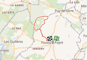
Randonnée Marche de 11,3 km à découvrir à Pays de la Loire, Vendée, Foussais-Payré. Cette randonnée est proposée par meunier.ph..
Description
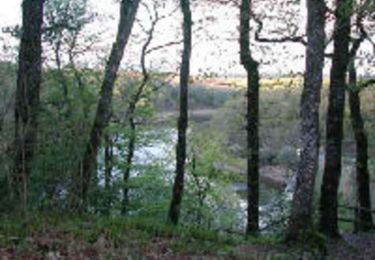
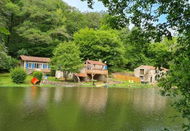
Jolis chemins creux, petites routes et 3 étangs. A éviter après de fortes pluies car, à certains endroits seulement, le sentier peut être très boueux.
Localisation
Pays :
France
Région :
Pays de la Loire
Département/Province :
Vendée
Commune :
Foussais-Payré
Localité :
Unknown
Départ:(Dec)
Départ:(UTM)
677742 ; 5155535 (30T) N.
Commentaires
Randonnées à proximité
![Randonnée Marche Saint-Maurice-des-Noues - rando du 29-05-2021. famille viault-durand - Photo](https://media.geolcdn.com/t/375/260/7ff857b0-2830-4d17-b3a4-b707fa148f09.jpg&format=jpg&maxdim=2)
![Marche Marche](https://static1.geolcdn.com/sitytour/trail-icons/101.png)
rando du 29-05-2021. famille viault-durand
Marche
Très difficile
Saint-Maurice-des-Noues,
Pays de la Loire,
Vendée,
France
![](/images/other/stat-length.png)
21 km | 25 km-effort
5h 2min
![](https://static1.geolcdn.com/siteimages/upload/files/16400158638029165_repeat_loop_refresh_sync_direction_icon.png)
Oui
![Randonnée V.T.T. Vouvant - Forêt de Mervent - Photo](https://media.geolcdn.com/t/375/260/ext.jpg?maxdim=2&url=https%3A%2F%2Fservices.sitytrail.com%2FGeolivesWS%2FDownloadMedia.ashx%3FTrailID%3D100756%26Media%3D268_2.jpg)
![V.T.T. V.T.T.](https://static1.geolcdn.com/sitytour/trail-icons/202.png)
Forêt de Mervent
V.T.T.
Très difficile
Vouvant,
Pays de la Loire,
Vendée,
France
![](/images/other/stat-length.png)
39 km | 47 km-effort
3h 0min
![](https://static1.geolcdn.com/siteimages/upload/files/16400158638029165_repeat_loop_refresh_sync_direction_icon.png)
Oui
![Randonnée Marche Puy-de-Serre - GR364-Jour n°2 - Photo](https://media.geolcdn.com/t/375/260/ext.jpg?maxdim=2&url=https%3A%2F%2Fstatic1.geolcdn.com%2Fsiteimages%2Fupload%2Ffiles%2F1553511878bg_sport_marche.png)
![Marche Marche](https://static1.geolcdn.com/sitytour/trail-icons/101.png)
GR364-Jour n°2
Marche
Très difficile
Puy-de-Serre,
Pays de la Loire,
Vendée,
France
![](/images/other/stat-length.png)
23 km | 26 km-effort
5h 53min
![](https://static1.geolcdn.com/siteimages/upload/files/16400158638029165_repeat_loop_refresh_sync_direction_icon.png)
Non
![Randonnée V.T.T. Foussais-Payré - reco - Photo](https://media.geolcdn.com/t/375/260/ext.jpg?maxdim=2&url=https%3A%2F%2Fstatic1.geolcdn.com%2Fsiteimages%2Fupload%2Ffiles%2F1524743154velo.jpg)
![V.T.T. V.T.T.](https://static1.geolcdn.com/sitytour/trail-icons/202.png)
reco
V.T.T.
Difficile
Foussais-Payré,
Pays de la Loire,
Vendée,
France
![](/images/other/stat-length.png)
36 km | 41 km-effort
1h 50min
![](https://static1.geolcdn.com/siteimages/upload/files/16400158638029165_repeat_loop_refresh_sync_direction_icon.png)
Non
![Randonnée Marche Saint-Maurice-des-Noues - Epagnes - Photo](https://media.geolcdn.com/t/375/260/ext.jpg?maxdim=2&url=https%3A%2F%2Fstatic1.geolcdn.com%2Fsiteimages%2Fupload%2Ffiles%2F1553511878bg_sport_marche.png)
![Marche Marche](https://static1.geolcdn.com/sitytour/trail-icons/101.png)
Epagnes
Marche
Moyen
Saint-Maurice-des-Noues,
Pays de la Loire,
Vendée,
France
![](/images/other/stat-length.png)
23 km | 27 km-effort
6h 21min
![](https://static1.geolcdn.com/siteimages/upload/files/16400158638029165_repeat_loop_refresh_sync_direction_icon.png)
Oui
![Randonnée Marche Vouvant - rando Mervent le 20 Mai 2021 - Photo](https://media.geolcdn.com/t/375/260/be5232dd-4bec-411b-995d-5c3c088faad5.jpg&format=jpg&maxdim=2)
![Marche Marche](https://static1.geolcdn.com/sitytour/trail-icons/101.png)
rando Mervent le 20 Mai 2021
Marche
Très difficile
Vouvant,
Pays de la Loire,
Vendée,
France
![](/images/other/stat-length.png)
17,1 km | 21 km-effort
4h 27min
![](https://static1.geolcdn.com/siteimages/upload/files/16400158638029165_repeat_loop_refresh_sync_direction_icon.png)
Oui
![Randonnée Marche Vouvant - circuit de 17,300 - Photo](https://media.geolcdn.com/t/375/260/ext.jpg?maxdim=2&url=https%3A%2F%2Fstatic1.geolcdn.com%2Fsiteimages%2Fupload%2Ffiles%2F1553511878bg_sport_marche.png)
![Marche Marche](https://static1.geolcdn.com/sitytour/trail-icons/101.png)
circuit de 17,300
Marche
Très difficile
Vouvant,
Pays de la Loire,
Vendée,
France
![](/images/other/stat-length.png)
17,3 km | 21 km-effort
4h 49min
![](https://static1.geolcdn.com/siteimages/upload/files/16400158638029165_repeat_loop_refresh_sync_direction_icon.png)
Oui
![Randonnée Marche Foussais-Payré - 85240 Foussais-Payré - Photo](https://media.geolcdn.com/t/375/260/ext.jpg?maxdim=2&url=https%3A%2F%2Fstatic1.geolcdn.com%2Fsiteimages%2Fupload%2Ffiles%2F1553511878bg_sport_marche.png)
![Marche Marche](https://static1.geolcdn.com/sitytour/trail-icons/101.png)
85240 Foussais-Payré
Marche
Très facile
Foussais-Payré,
Pays de la Loire,
Vendée,
France
![](/images/other/stat-length.png)
10,4 km | 11,8 km-effort
2h 54min
![](https://static1.geolcdn.com/siteimages/upload/files/16400158638029165_repeat_loop_refresh_sync_direction_icon.png)
Oui
![Randonnée Marche Foussais-Payré - Foussay-Perray - Photo](https://media.geolcdn.com/t/375/260/ext.jpg?maxdim=2&url=https%3A%2F%2Fstatic1.geolcdn.com%2Fsiteimages%2Fupload%2Ffiles%2F1553511878bg_sport_marche.png)
![Marche Marche](https://static1.geolcdn.com/sitytour/trail-icons/101.png)
Foussay-Perray
Marche
Facile
Foussais-Payré,
Pays de la Loire,
Vendée,
France
![](/images/other/stat-length.png)
9,7 km | 11 km-effort
3h 3min
![](https://static1.geolcdn.com/siteimages/upload/files/16400158638029165_repeat_loop_refresh_sync_direction_icon.png)
Non