![](/images/other/stat-length.png)
![Randonnée Marche Hannut - Avin, La Balade des Sources - Photo](https://media.geolcdn.com/t/1900/400/ext.pjpeg?maxdim=2&url=https%3A%2F%2Fstatic1.geolcdn.com%2Fsiteimages%2Fupload%2Ffiles%2F1553511878bg_sport_marche.png)
Avin, La Balade des Sources
PhilippeetEvelyne
Utilisateur
![Longueur](/images/other/stat-length.png)
Longueur
7,5 km
![Altitude max](https://static1.geolcdn.com/siteimages/upload/files/1508320355ic_sort_altitude_max_24dp.png)
Altitude max
145 m
![Dénivelé positif](https://static1.geolcdn.com/siteimages/upload/files/1508320355ic_sort_den_pos_24dp.png)
Dénivelé positif
57 m
![Km-Effort](/images/other/stat-length.png)
Km-Effort
8,3 km
![Altitude min](https://static1.geolcdn.com/siteimages/upload/files/1508320355ic_sort_altitude_min_24dp.png)
Altitude min
118 m
![Dénivelé négatif](https://static1.geolcdn.com/siteimages/upload/files/1508320355ic_sort_den_neg_24dp.png)
Dénivelé négatif
57 m
![Boucle](https://static1.geolcdn.com/siteimages/upload/files/16400158638029165_repeat_loop_refresh_sync_direction_icon.png)
Boucle
Oui
Date de création :
2021-10-17 10:39:13.527
Dernière modification :
2021-10-17 10:43:52.314
![Marche](https://static1.geolcdn.com/sitytour/trail-icons/101.png)
1h53
Difficulté : Très facile
![Scannez ce code QR pour ouvrir la randonnée dans l'application SityTrail](https://capi.geolives.com/qq0zvz2zws4bq2lad0pu/sitytour/trails/2972903/qr.png?size=200)
Application GPS de randonnée GRATUITE
À propos
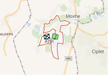
Randonnée Marche de 7,5 km à découvrir à Wallonie, Liège, Hannut. Cette randonnée est proposée par PhilippeetEvelyne.
Description
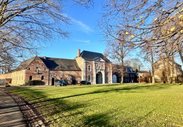
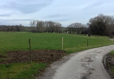
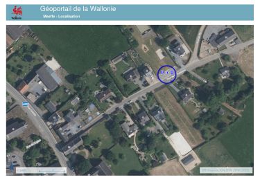
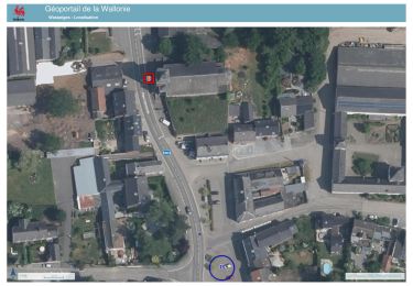
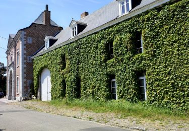
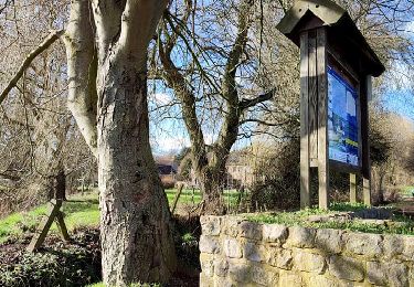
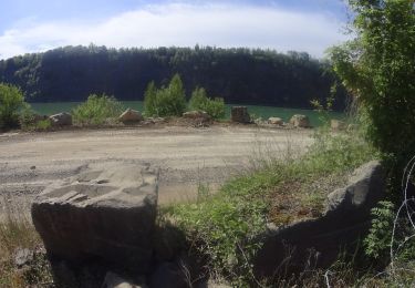
Des sentiers bucoliques, notamment le long de la Mehaigne, un riche patrimoine historique, une chasse aux trésors « géocachés », voici quelques aspects que vous découvrirez en parcourant la balade des sources à Avin. Point de départ : place du Mohéry - Rue du Mohéry
Localisation
Pays :
Belgique
Région :
Wallonie
Département/Province :
Liège
Commune :
Hannut
Localité :
Unknown
Départ:(Dec)
Départ:(UTM)
646344 ; 5609623 (31U) N.
Commentaires
Randonnées à proximité
![Randonnée Marche Hannut - La Balade des Chevées - Photo](https://media.geolcdn.com/t/375/260/c40a8656-229d-4d2b-8925-ffea50baaa2d.jpeg&format=jpg&maxdim=2)
![Marche Marche](https://static1.geolcdn.com/sitytour/trail-icons/101.png)
La Balade des Chevées
Marche
Facile
(1)
Hannut,
Wallonie,
Liège,
Belgique
![](/images/other/stat-length.png)
5,2 km | 5,7 km-effort
1h 17min
![](https://static1.geolcdn.com/siteimages/upload/files/16400158638029165_repeat_loop_refresh_sync_direction_icon.png)
Oui
![Randonnée Marche Braives - Boucle Moulin de Velupont - Photo](https://media.geolcdn.com/t/375/260/ext.jpg?maxdim=2&url=https%3A%2F%2Fservices.sitytrail.com%2FGeolivesWS%2FDownloadMedia.ashx%3FTrailID%3D705146%26Media%3Dfix__20170225113122.jpg)
![Marche Marche](https://static1.geolcdn.com/sitytour/trail-icons/101.png)
Boucle Moulin de Velupont
Marche
Très facile
(4)
Braives,
Wallonie,
Liège,
Belgique
![](/images/other/stat-length.png)
4,6 km | 5,2 km-effort
55min
![](https://static1.geolcdn.com/siteimages/upload/files/16400158638029165_repeat_loop_refresh_sync_direction_icon.png)
Oui
![Randonnée Marche Wasseiges - 20240307 - TOTEMUS Meeffe - 5.8 Km - Photo](https://media.geolcdn.com/t/375/260/7d0d7efb-8092-424b-91ec-d478748d7f53.jpeg&format=jpg&maxdim=2)
![Marche Marche](https://static1.geolcdn.com/sitytour/trail-icons/101.png)
20240307 - TOTEMUS Meeffe - 5.8 Km
Marche
Facile
Wasseiges,
Wallonie,
Liège,
Belgique
![](/images/other/stat-length.png)
5,8 km | 6,3 km-effort
1h 56min
![](https://static1.geolcdn.com/siteimages/upload/files/16400158638029165_repeat_loop_refresh_sync_direction_icon.png)
Oui
![Randonnée Marche Wasseiges - 20240307 - TOTEMUS Wasseiges- 3.2 Km - Photo](https://media.geolcdn.com/t/375/260/c42a9b7b-cd65-45b2-bbb9-49294bcad449.jpeg&format=jpg&maxdim=2)
![Marche Marche](https://static1.geolcdn.com/sitytour/trail-icons/101.png)
20240307 - TOTEMUS Wasseiges- 3.2 Km
Marche
Facile
Wasseiges,
Wallonie,
Liège,
Belgique
![](/images/other/stat-length.png)
3,2 km | 3,5 km-effort
48min
![](https://static1.geolcdn.com/siteimages/upload/files/16400158638029165_repeat_loop_refresh_sync_direction_icon.png)
Oui
![Randonnée Marche Hannut - La balade des chevées (5km) - Photo](https://media.geolcdn.com/t/375/260/4f5eaa7c-e24d-4247-898f-e668713f7776.jpg&format=jpg&maxdim=2)
![Marche Marche](https://static1.geolcdn.com/sitytour/trail-icons/101.png)
La balade des chevées (5km)
Marche
Facile
(1)
Hannut,
Wallonie,
Liège,
Belgique
![](/images/other/stat-length.png)
5,3 km | 5,7 km-effort
1h 18min
![](https://static1.geolcdn.com/siteimages/upload/files/16400158638029165_repeat_loop_refresh_sync_direction_icon.png)
Oui
![Randonnée Marche Hannut - La promenade de la Mouhagne - Photo](https://media.geolcdn.com/t/375/260/992bf509-1491-4136-a1e0-5816e773d65e.jpg&format=jpg&maxdim=2)
![Marche Marche](https://static1.geolcdn.com/sitytour/trail-icons/101.png)
La promenade de la Mouhagne
Marche
Moyen
(2)
Hannut,
Wallonie,
Liège,
Belgique
![](/images/other/stat-length.png)
7,9 km | 9 km-effort
2h 3min
![](https://static1.geolcdn.com/siteimages/upload/files/16400158638029165_repeat_loop_refresh_sync_direction_icon.png)
Oui
![V.T.T. V.T.T.](https://static1.geolcdn.com/sitytour/trail-icons/202.png)
VTT autour de Burdinne
V.T.T.
Très difficile
Burdinne,
Wallonie,
Liège,
Belgique
![](/images/other/stat-length.png)
55 km | 68 km-effort
4h 41min
![](https://static1.geolcdn.com/siteimages/upload/files/16400158638029165_repeat_loop_refresh_sync_direction_icon.png)
Oui
![Randonnée Marche Burdinne - OTEPPE - Photo](https://media.geolcdn.com/t/375/260/ext.jpg?maxdim=2&url=https%3A%2F%2Fstatic1.geolcdn.com%2Fsiteimages%2Fupload%2Ffiles%2F1553511878bg_sport_marche.png)
![Marche Marche](https://static1.geolcdn.com/sitytour/trail-icons/101.png)
![Randonnée Marche Burdinne - w-belgie-kwikstaartenwandeling - Photo](https://media.geolcdn.com/t/375/260/ext.jpg?maxdim=2&url=https%3A%2F%2Fstatic1.geolcdn.com%2Fsiteimages%2Fupload%2Ffiles%2F1553511878bg_sport_marche.png)
![Marche Marche](https://static1.geolcdn.com/sitytour/trail-icons/101.png)
w-belgie-kwikstaartenwandeling
Marche
Très facile
(2)
Burdinne,
Wallonie,
Liège,
Belgique
![](/images/other/stat-length.png)
8,6 km | 10,6 km-effort
Inconnu
![](https://static1.geolcdn.com/siteimages/upload/files/16400158638029165_repeat_loop_refresh_sync_direction_icon.png)
Oui